

Welcome to your ultimate trip to spain guide, where Mediterranean charm meets rich history and vibrant culture. Spain captivates travelers with its diverse landscapes, from golden beaches to snow-capped mountains, and cities that pulse with energy day and night. Whether you’re dreaming of savoring authentic paella in Valencia, wandering through Gaudí’s masterpieces in Barcelona, or dancing until dawn in Madrid, this Spain travel guide will help you craft the perfect itinerary. Join me as we explore hidden gems, must-see attractions, and practical tips that will transform your Spanish adventure from ordinary to extraordinary. Let’s begin our journey through this passionate country where every region tells a unique story.
Spain stands as one of Europe’s premier tourism destinations, offering a remarkable blend of cultural richness, geographical diversity, and world-class hospitality.
Spain’s tourism appeal extends across distinct regions, each with its own character. Barcelona showcases Gaudí’s architectural masterpieces and Mediterranean beaches, while Madrid offers prestigious museums and vibrant urban life. The southern region of Andalusia presents Moorish heritage in cities like Granada and Seville, complemented by Costa del Sol’s celebrated resorts.
The country’s tourism infrastructure excels with extensive high-speed rail networks, international airports, and accommodation options ranging from luxury resorts to boutique hotels. Spanish cuisine further enhances the visitor experience with regional specialties, tapas culture, and Michelin-starred establishments.
Spain has successfully diversified beyond its traditional “sun and beach” model to promote cultural tourism, gastronomic experiences, and sustainable travel initiatives. This strategic approach ensures the country maintains its competitive advantage in global tourism while addressing seasonal fluctuations and environmental considerations.
Spain Overview
- Official name: Kingdom of Spain (Reino de España)
- Capital: Madrid
- Languages: Spanish (Castilian) is official nationwide; Catalan, Galician, Basque, and Valencian are co-official in respective regions
- Government: Parliamentary constitutional monarchy
- Currency: Euro (€)
- Geography: Located on Iberian Peninsula in southwestern Europe; includes Balearic Islands in Mediterranean and Canary Islands in Atlantic
- Borders:
-
- Portugal (1,214 km) – west
- France (623 km) – northeast
- Andorra (63 km) – north
- Gibraltar (1.2 km) – south
- Morocco (Ceuta and Melilla, 16 km) – North Africa
- Time Zone: Central European Time (CET) in winter (UTC+1) and Central European Summer Time (CEST) in summer (UTC+2). The Canary Islands use Western European Time (WET/UTC+0) in winter and Western European Summer Time (WEST/UTC+1) in summer.
- Top tourist destinations: Barcelona, Madrid, Seville, Granada, Valencia, Mallorca, Ibiza
- UNESCO World Heritage Sites: 49 sites (fourth-highest globally)
- Culinary specialties: Paella, tapas, jamón ibérico, sangria, churros
- Famous festivals: La Tomatina, Running of the Bulls, La Feria de Abril, Las Fallas
- Sports: Home to top football clubs including Real Madrid and FC Barcelona
Best places to visit in Spain
Barcelona

Barcelona stands as one of Spain’s most captivating destinations, blending stunning architecture, rich cultural heritage, beautiful beaches, and vibrant city life. The Catalan capital offers visitors an extraordinary mix of experiences that makes it uniquely appealing among European cities.
For More details visit: https://www.spain.info/en/
-
Sagrada Familia
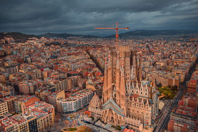
Antoni Gaudí’s unfinished masterpiece represents the pinnacle of Modernist architecture. Construction began in 1882 and continues today, with completion expected around 2026. The basilica’s exterior features intricate facades depicting the Nativity and Passion of Christ, while the interior astounds visitors with soaring columns designed to resemble a stone forest, with light filtering through stained glass windows in a rainbow of colors.
The geometric precision and natural inspirations throughout the structure reveal Gaudí’s mathematical genius and spiritual vision. Visitors should book tickets well in advance and consider the audio guide to fully appreciate the symbolism and architectural innovations.
Connectivity:
By Metro (Subway)
The metro is the most convenient public transportation option:
- Line 2 (Purple): Get off at “Sagrada Familia” station
- Line 5 (Blue): Get off at “Sagrada Familia” station
- Both lines connect at this station, which has exits leading directly to the basilica
By Bus
Several bus lines stop near the Sagrada Familia:
- Bus lines 19, 33, 34, 50, and 51: All have stops within a short walking distance
- Barcelona Tourist Bus (hop-on-hop-off): Has a dedicated Sagrada Familia stop
- Bus H10: Stops on Mallorca street, very close to the basilica
By Taxi
Taxis are readily available throughout Barcelona. Simply ask the driver to take you to “La Sagrada Familia.” There are designated taxi stands near the basilica where you can easily find a taxi for your return journey.
By Car
If you’re driving, be aware that parking near Sagrada Familia can be challenging. Your best options are:
- Saba Parking Sagrada Familia: Underground parking located at Carrer de Mallorca, 412-420, just 2 minutes walk from the basilica
- BAMSA Sagrada Familia: Another underground parking facility at Carrer Sardenya, 311
- BSM Plaça de la Sagrada Familia: Public parking at Plaza de la Sagrada Familia
- ApparkB zones: Blue or green marked street parking spaces (payable via app or parking meters)
Remember that traffic in this area is often congested, especially during peak tourist seasons.
Important Details
- Address: Carrer de Mallorca, 401, 08013 Barcelona, Spain
- GPS Coordinates: 41.4036° N, 2.1744° E
- Opening Hours: Generally 9:00 AM to 6:00 PM (varies by season)
- Advance Tickets: Highly recommended to avoid long queues
- Best Entrance: The Nativity Façade (eastern side) is often less crowded
-
Park Güell

Another Gaudí masterpiece, this public park was originally conceived as a residential development but later transformed into a municipal garden. The park showcases Gaudí’s signature style with organic shapes, colorful mosaics, and integration with the natural landscape. The famous mosaic salamander (known as “el drac”) greets visitors at the entrance, while the undulating bench encircling the main terrace offers panoramic views of Barcelona and the Mediterranean.
The park blends architectural elements with nature in a way that feels both whimsical and harmonious, demonstrating Gaudí’s belief that architecture should mirror the natural world.this elevation makes transportation planning important. Here’s a comprehensive guide to reaching this iconic park.
Connectivity:
By Metro (Subway)
The metro doesn’t reach Park Güell directly, but there are stations within walking distance:
- Line 3 (Green): Get off at “Lesseps” station or “Vallcarca” station
- From Lesseps: About a 15-minute uphill walk (800 meters). Follow the green footprints painted on the sidewalk that guide visitors to the park.
- From Vallcarca: Also about a 15-minute walk but with escalators to help with the steep sections, making it often the easier route despite being slightly farther.
By Bus
Several bus lines offer stops closer to the park entrances than the metro:
- Bus 24: Stops directly at one of the park entrances (Carretera del Carmel entrance)
- Bus H6: Stops near the main entrance on Carrer d’Olot
- Bus 92: Stops at the upper part of the park
- Barcelona Tourist Bus (Blue Route): Has a dedicated Park Güell stop
The bus is often the most convenient public transportation option as it brings you much closer to the entrances than the metro.
By Taxi
Taxis in Barcelona are readily available and can drop you off at the main entrance on Carrer d’Olot or the Carretera del Carmel entrance. Using ride-sharing apps like Cabify (Uber has limited service in Barcelona) is also an option.
Expect to pay approximately €10-15 from the city center, depending on traffic conditions.
By Car
If you’re driving, be aware that parking near Park Güell can be extremely challenging due to narrow streets and limited spaces:
- BSM Park Güell: The official parking facility at Carrer de Sant Josep de la Muntanya, 25. Small but convenient, about a 5-minute walk to the main entrance.
- Parking Carretera del Carmel: Located closer to the upper entrance of the park.
- Street parking: Limited blue zone (regulated paid parking) spots are available in the surrounding streets, but they fill up quickly, especially during peak tourist season.
The neighborhood has many steep, narrow one-way streets, which can be stressful to navigate. Public transportation is strongly recommended unless you’re familiar with driving in Barcelona.
Important Details for Your Visit
- Address: Carrer d’Olot, 5, 08024 Barcelona, Spain
- GPS Coordinates: 41.4145° N, 2.1527° E
- Main Entrances:
- Carrer d’Olot entrance (main entrance, lower part of the park)
- Carretera del Carmel entrance (upper part of the park)
- Sant Josep de la Muntanya entrance (eastern side)
- Opening Hours: Generally 9:30 AM to sunset (varies by season)
- Ticket Information: Only the Monumental Zone requires paid entry, which includes Gaudí’s famous works like the Dragon Stairway and Hypostyle Room. The surrounding park area is free to enter.
- Advance Tickets: Highly recommended to secure your preferred time slot, as daily visitor numbers are restricted.
-
Gothic Quarter (Barri Gòtic)
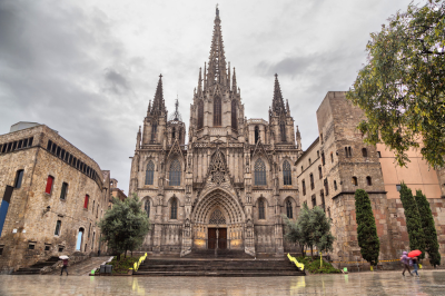
The historic heart of Barcelona dates back to Roman times and features a labyrinth of narrow medieval streets and atmospheric squares. As you wander through this pedestrian-friendly district, you’ll encounter the impressive Barcelona Cathedral, hidden plazas like Plaça del Rei and Plaça Sant Felip Neri, and remnants of the ancient Roman city walls.
The quarter houses numerous small shops, traditional bars, and restaurants where you can sample authentic Catalan cuisine. The area comes alive particularly in the evening, when locals and visitors gather at outdoor terraces to enjoy tapas and local wines.
Connectivity:
By Metro
- Line 4 (Yellow): Jaume I station – directly in the Gothic Quarter
- Exit toward Carrer de l’Argenteria for fastest access
- Operating hours: 5:00 AM – midnight (Sun-Thurs), 5:00 AM – 2:00 AM (Fri), 24 hours (Sat)
- Line 3 (Green): Liceu station – western edge of the Quarter
- Exit toward La Rambla/Plaça Reial
- Connected to several bus routes
- Line 1 (Red) or Line 3 (Green): Catalunya station – northern edge
- Major interchange station with suburban trains
- Connected to Aerobus services from the airport
By Bus
- Tourist Bus (Barcelona Bus Turístic): Stops at Plaça Catalunya and Port Vell
- Airport Bus (Aerobus): A1 and A2 lines terminate at Plaça Catalunya
- Night Buses (Nitbus): N8, N9, N12, and N15 serve the area after regular service ends
- Regular Routes: 14, 17, 19, 40, 45, 59, 91, 120, V15, V17, and D20
- Bus 59 is particularly useful as it runs down Via Laietana with stops at both Jaume I and Correos
By Train
- Renfe Rodalies: Barcelona Plaça Catalunya station
- Serves R1, R3, R4, and R7 suburban lines
- Direct connection to El Prat Airport (R2 Nord)
- FGC (Ferrocarrils de la Generalitat): Plaça Catalunya station
- Serves lines L6, L7, S1, S2, S5, S6, and S7
- Underground connection to Metro system
Detailed Parking Information
- SABA Cathedral Parking:
- Address: Av. de la Catedral, 6
- 385 spaces, 24/7 operation
- Daily rates around €30-35
- Pre-booking available via app
- BSM Moll d’Espanya:
- 750 spaces, slightly cheaper rates
- Good option for approaching from the port
- BAMSA La Gardunya:
- Near La Boqueria Market
- 428 spaces on multiple levels
- Recently renovated facility
- Smaller parkings:
- Plaça George Orwell (limited spaces)
- Parking Palau de la Música (good for approaching from northern side)
Recommended Entry Points & Routes
- For first-time visitors: Enter via Plaça Nova/Barcelona Cathedral for the most impressive introduction
- For shopping: Enter from Portal de l’Àngel shopping street
- For food lovers: Enter via La Boqueria market and walk through Las Ramblas
- For architecture enthusiasts: Enter via Via Laietana to appreciate the contrast between Gothic and modernist styles
Navigation Tips
- Many streets change names frequently as they progress through the quarter
- Plaça Sant Jaume (with City Hall and Palau de la Generalitat) serves as a good central reference point
- The main spine of the quarter runs from Plaça Nova (Cathedral) to Plaça Reial
- Mobile reception can be spotty in some of the narrowest streets – download offline maps in advance
-
La Rambla and Mercat de la Boqueria

La Rambla is Barcelona’s most famous boulevard, a tree-lined pedestrian street stretching from Plaça de Catalunya to the Columbus Monument at Port Vell. This vibrant promenade bustles with street performers, flower stalls, and outdoor cafés. Along this cultural artery, you’ll find the magnificent Gran Teatre del Liceu opera house and the entrance to Mercat de la Boqueria, one of Europe’s finest food markets.
Inside the market, colorful stalls display an astonishing variety of fresh fruits, vegetables, seafood, meats, cheeses, and local specialties like jamón ibérico. The market offers both a feast for the eyes and an opportunity to sample authentic Catalan gastronomy.
Connectivity:
La Rambla
Address: La Rambla, 08002 Barcelona, Spain
Mercat de la Boqueria (La Boqueria Market)
Located just off La Rambla, this is one of Barcelona’s most famous food markets.
Address: La Rambla, 91, 08001 Barcelona, Spain
Opening Hours:
- Monday to Saturday: 8:00 AM – 8:30 PM
- Sundays and Public Holidays: Closed
- Many stalls may close earlier (around 8:00 PM)
- Some vendors take afternoon breaks (typically 2:00 PM – 5:00 PM)
Transportation Options
By Metro
- Liceu Station (Line 3 – Green): Located directly on La Rambla, closest to La Boqueria
- Exit the station and La Boqueria is approximately 100 meters north
- Operating hours: 5:00 AM – midnight (Sun-Thurs), 5:00 AM – 2:00 AM (Fri), 24 hours (Sat)
- Drassanes Station (Line 3 – Green): Southern end of La Rambla
- Catalunya Station (Lines 1 & 3 – Red & Green): Northern end of La Rambla
- Major interchange station with connections to regional trains
By Bus
- Lines serving La Rambla area: 14, 59, 91, 120, V13, D20
- Tourist Bus (Barcelona Bus Turístic): Blue and Red routes stop at Plaça Catalunya
- Airport Bus (Aerobus): A1 and A2 lines terminate at Plaça Catalunya
- Night Buses: N9, N12, N15 serve the area after regular service hours
By Train
- Barcelona Plaça Catalunya Station:
- Serves Renfe commuter lines (R1, R3, R4, R7)
- Connects to Barcelona El Prat Airport via R2 Nord
- FGC Station at Plaça Catalunya:
- Serves lines L6, L7, S1, S2, S5, S6, S7
By Taxi/Ride-Share
- Taxi stands located at:
- Plaça Catalunya (northern end of La Rambla)
- Liceu Theater (middle of La Rambla)
- Columbus Monument (southern end)
- Ride-sharing apps operate throughout Barcelona
Parking Options
Public Parking Garages
- SABA La Rambla:
- Address: La Rambla, 80
- Directly on La Rambla, closest to La Boqueria
- 24/7 operation
- 429 spaces
- Daily rates around €30-35
- BAMSA La Gardunya:
- Address: Plaça de la Gardunya (behind La Boqueria)
- Recently renovated facility
- 428 spaces
- Slightly more affordable than La Rambla parking
- BSM Moll d’Espanya:
- Near Port Vell (southern end of La Rambla)
- 750 spaces
- Good option for approaching from the port area
- Parking Raval – Centre d’Art Santa Mònica:
- Near the Columbus Monument
- 165 spaces
Walking Access
- From Gothic Quarter: Multiple access points along the eastern side of La Rambla
- From El Raval: La Boqueria is on the western side of La Rambla
- From Port Vell: Walk north on La Rambla for approximately 15 minutes
- From Plaça Catalunya: Walk south on La Rambla for approximately 10 minutes
Practical Tips
- Best times to visit La Boqueria:
- Early morning (8:00 AM – 10:00 AM) for the freshest products and fewer crowds
- Avoid peak hours (11:00 AM – 2:00 PM) when tourist groups are most common
- Navigation landmarks:
- La Boqueria’s main entrance is marked by a distinctive modernist iron and stained glass sign
- Look for the Canaletas Fountain at the northern end of La Rambla
- The Liceu Opera House is a major landmark near La Boqueria
-
Casa Batlló and Passeig de Gràcia
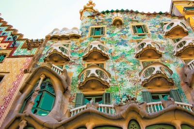
Located on the elegant Passeig de Gràcia boulevard, Casa Batlló represents another of Gaudí’s architectural masterpieces. This extraordinary building, redesigned by Gaudí in 1904, features a façade that appears to be made from skulls and bones (the balconies) and is topped with a roof resembling a dragon’s back.
Inside, the building continues to surprise with its absence of straight lines, marine-inspired details, and ingenious use of light. The surrounding Passeig de Gràcia itself deserves exploration as Barcelona’s most luxurious shopping avenue, home to additional Modernist buildings like Casa Milà (La Pedrera) and high-end boutiques.
Connectivity:
Casa Batlló
Address: Passeig de Gràcia, 43, 08007 Barcelona, Spain
Opening Hours:
- Daily: 9:00 AM – 8:00 PM (last entry at 7:00 PM)
- Extended hours during summer season (usually until 9:00 PM)
- Open 365 days a year, including holidays
Official Website: casabatllo.es
Passeig de Gràcia
Transportation Options
By Metro
- Passeig de Gràcia Station (Lines 2, 3, 4 – Purple, Green, Yellow):
- Main interchange station directly serving the area
- Take Exit “Passeig de Gràcia – Casa Batlló” for the most direct route
- Operating hours: 5:00 AM – midnight (Sun-Thurs), 5:00 AM – 2:00 AM (Fri), 24 hours (Sat)
- Diagonal Station (Lines 3, 5 – Green, Blue): Northern end of Passeig de Gràcia
By Bus
- Regular Routes: 7, 22, 24, V15, H10, D50 all stop near Casa Batlló
- Tourist Bus (Barcelona Bus Turístic):
- Blue Route stops at “Passeig de Gràcia – La Pedrera”
- Daily service from 9:00 AM – 7:00 PM (winter) or 8:00 PM (summer)
- Night Buses: N4, N5, N6 serve Passeig de Gràcia after regular service hours
By Train
- Passeig de Gràcia Station:
- Serves Renfe commuter lines (R2, R2 Nord, R2 Sud, R11, R13, R14, R15, R16)
- Direct connection to Barcelona El Prat Airport via R2 Nord
- High-speed AVE trains also stop here
By Taxi/Ride-Share
- Taxi stands located at:
- In front of Casa Batlló
- Corner of Passeig de Gràcia and Carrer d’Aragó
- Corner of Passeig de Gràcia and Gran Via
- Ride-sharing apps operate throughout Barcelona
Parking Options
Public Parking Garages
- SABA Passeig de Gràcia:
- Address: Passeig de Gràcia, 56
- Only 300 meters from Casa Batlló
- 24/7 operation
- 443 spaces
- Premium rates (approximately €3.60-4.00/hour)
- BSM Plaça de Catalunya:
- Address: Plaça de Catalunya, 1
- 10-minute walk to Casa Batlló
- 939 spaces
- Slightly more affordable than Passeig de Gràcia parking
- SABA Rambla Catalunya:
- Address: Rambla de Catalunya, 15
- 5-minute walk to Casa Batlló
- 273 spaces
- NN Valencia:
- Address: Carrer de València, 243
- 5-minute walk from Casa Batlló
- 409 spaces
Additional Information
The “Block of Discord”
Casa Batlló is part of the famous “Illa de la Discòrdia” (Block of Discord), which features buildings by different modernist architects:
- Casa Batlló by Antoni Gaudí
- Casa Amatller by Josep Puig i Cadafalch
- Casa Lleó Morera by Lluís Domènech i Montaner All are within 100 meters of each other on Passeig de Gràcia
Nearby Attractions
- Casa Milà (La Pedrera): Another Gaudí masterpiece, 550 meters north on Passeig de Gràcia
- Plaça Catalunya: Major city square, 900 meters south
- Fundació Antoni Tàpies: Contemporary art museum, 300 meters away
- Luxury Shopping: High-end boutiques including Chanel, Louis Vuitton, Gucci, and Prada
-
Montjuïc Hill

Rising prominently above the city’s southwestern edge, Montjuïc Hill offers a delightful escape from urban bustle while providing some of Barcelona’s most important cultural institutions. Visitors can ascend via cable car for spectacular panoramic views of the city and Mediterranean Sea.
The hill houses the impressive National Art Museum of Catalonia (MNAC), featuring one of the world’s finest collections of Romanesque art. The area also contains the 1992 Olympic facilities, the Magic Fountain that performs choreographed water shows set to music and lights, beautiful botanical gardens, and Montjuïc Castle, an old military fortress with centuries of history.
The various attractions are connected by peaceful walking paths through lush gardens, making Montjuïc perfect for combining cultural experiences with natural beauty.
Connectivity:
General Information
Location: Southwest of Barcelona’s city center, rising 173 meters above sea level
Access Hours:
- The hill itself is accessible 24/7
- Individual attractions have their own opening hours (detailed below)
- Most gardens are open from sunrise to sunset
Major Attractions on Montjuïc
Montjuïc Castle (Castell de Montjuïc)
- Hours: Daily 10:00 AM – 8:00 PM (April-October), 10:00 AM – 6:00 PM (November-March)
- Address: Carretera de Montjuïc, 66
Magic Fountain (Font Màgica)
- Hours: Light shows typically Thursday-Sunday evenings (schedule varies by season)
- Location: Plaça de Carles Buïgas
National Art Museum of Catalonia (MNAC)
- Hours: Tuesday-Saturday 10:00 AM – 8:00 PM, Sundays 10:00 AM – 3:00 PM, Closed Mondays
- Address: Palau Nacional, Parc de Montjuïc
Joan Miró Foundation
- Hours: Tuesday-Saturday 10:00 AM – 6:00 PM (8:00 PM in summer), Sundays 10:00 AM – 3:00 PM, Closed Mondays
- Address: Parc de Montjuïc
Olympic Ring
- Hours: Olympic Stadium exterior accessible anytime, Olympic Museum hours vary
- Address: Passeig Olímpic, 15-17
Botanical Garden (Jardí Botànic)
- Hours: Daily 10:00 AM – 7:00 PM (April-October), 10:00 AM – 6:00 PM (November-March)
- Address: Carrer Doctor Font i Quer, 2
Transportation Options
By Metro
- Line 1 (Red): Espanya station – Main access point to Montjuïc
- Line 2 (Purple): Espanya station
- Line 3 (Green): Espanya station or Poble Sec station (northern side access)
- Line 8 (Pink): Espanya station
By Funicular & Cable Car
- Montjuïc Funicular:
- Connects from Paral·lel metro station (Lines 2 & 3) to halfway up Montjuïc
- Operating hours: Same as metro system
- Included in standard metro tickets/passes
- Montjuïc Cable Car (Telefèric de Montjuïc):
- Continues from the funicular’s top station to near the castle
- Hours: 10:00 AM – 7:00 PM (winter), 10:00 AM – 9:00 PM (summer)
- Separate ticket required (approximately €14 round-trip)
- Port Cable Car (Telefèric del Port):
- Connects Barceloneta with Montjuïc
- Separate from the Montjuïc Cable Car system
- Hours: 11:00 AM – 5:30 PM (winter), 10:30 AM – 8:00 PM (summer)
- Ticket: approximately €12 one-way, €19 round-trip
By Bus
- Regular Bus Lines:
- Line 55: From Plaça Catalunya to various Montjuïc locations
- Line 150: Circular route around Montjuïc hill
- Montjuïc Bus (Line 150):
- Circular route hitting all major Montjuïc attractions
- Frequency: Every 20-30 minutes
- Hours: Approximately 7:00 AM – 9:00 PM
- Tourist Bus (Barcelona Bus Turístic):
- Red Route includes several stops on Montjuïc
- Daily service from 9:00 AM – 7:00 PM (winter) or 8:00 PM (summer)
By Car
- Access via Avinguda Paral·lel, Avinguda de Miramar, or Carrer Lleida
- Navigation can be challenging due to winding roads and one-way systems
- GPS coordinates for castle: 41.3636° N, 2.1658° E
Parking Options
Free Parking Areas
- Street parking along Passeig Olímpic (limited spaces)
- Street parking near Joan Miró Foundation (limited spaces)
Paid Parking Garages
- BSM Poble Espanyol:
- Located near the Poble Espanyol attraction
- Approximately 300 spaces
- SABA Fira Barcelona Montjuïc:
- Address: Avinguda Reina Maria Cristina
- Near Plaça Espanya entrance to Montjuïc
- 800+ spaces
- BSM Rius i Taulet:
- Near MNAC and Magic Fountain
- 204 spaces
-
Barceloneta Beach and Port Olympic

Barcelona uniquely combines urban sophistication with seaside relaxation. Barceloneta Beach, the city’s most popular and accessible stretch of sand, lies just minutes from downtown. This vibrant beach offers golden sands, beach volleyball courts, outdoor gym equipment, and numerous chiringuitos (beach bars) serving refreshing drinks and seafood. The wide promenade is perfect for walking, jogging, or cycling along the Mediterranean.
Adjacent to the beach, Port Olympic was developed for the 1992 Olympics and now houses upscale restaurants, nightclubs, and a large marina filled with luxury yachts. The area is anchored by the iconic twin skyscrapers Hotel Arts and Torre Mapfre, with Frank Gehry’s massive golden fish sculpture (“El Peix”) glimmering between them—a modern landmark that has become symbolic of Barcelona’s coastal identity.
Connectivity:
By Metro (Subway)
The metro provides the most straightforward public transportation option to reach both areas:
For Barceloneta Beach:
- Line 4 (Yellow): Get off at “Barceloneta” station. From here, it’s approximately a 10-minute walk to the beach through the charming Barceloneta neighborhood. As you exit the station, follow signs toward “Platja” (beach in Catalan) or simply walk toward the sea along Passeig de Joan de Borbó.
For Port Olympic:
- Line 4 (Yellow): Get off at “Ciutadella | Vila Olímpica” station. This station is located just a 5-minute walk from Port Olympic. When you exit, head east toward the sea along Carrer de Salvador Espriu.
Both stations are connected by Line 4, making it easy to visit both locations in one day. The journey between these two stations takes only about 5 minutes.
By Bus
Several bus lines serve the coastal areas of Barcelona:
- Bus V21: Runs along the coastline, stopping at both Barceloneta Beach and Port Olympic
- Bus H16: Connects Passeig de Colom (near Barceloneta) to Port Olympic
- Bus 45: Stops near Barceloneta Beach
- Bus 59: Serves Port Olympic
- Bus 36: Stops near both areas
- Barcelona Tourist Bus (Red Route): Has stops at both Barceloneta and Port Olympic
These buses generally run every 10-15 minutes during the day, with reduced service in the evening and at night.
By Tram
- Trambesòs Line T4: Get off at “Ciutadella | Vila Olímpica” stop, which is very close to Port Olympic. This is a convenient option if you’re coming from the northern parts of Barcelona.
By Car
Driving to these areas is possible but not recommended due to limited parking and frequent congestion:
Parking Options for Barceloneta:
- BSM Passeig de Joan de Borbó: Underground parking near the Barceloneta neighborhood
- SABA Port Vell: Large underground parking facility at the nearby Port Vell
- Blue Zone street parking: Limited paid street parking in the area (difficult to find during summer months)
Parking Options for Port Olympic:
- BSM Port Olímpic: Underground parking beneath Port Olympic itself
- Centre de la Vila Shopping Center: Parking garage within walking distance
- Marina Port Olímpic: Parking for visitors to the marina
Expect to pay approximately €3-4 per hour for parking in these facilities. During summer weekends, these car parks fill up quickly, so arriving early is advisable.
By Taxi or Ride-Sharing
Taxis in Barcelona are plentiful and can drop you directly at your preferred entrance to either Barceloneta or Port Olympic. A taxi ride from the city center (Plaça Catalunya) to these areas typically costs around €10-15 depending on traffic. Cabify operates in Barcelona (Uber has limited service), and can be a convenient alternative to traditional taxis.
By Cable Car
For a more scenic approach:
- Teleférico del Puerto: This cable car runs from Montjuïc to Barceloneta, offering spectacular aerial views of the harbor and city. It departs from the Miramar station on Montjuïc and arrives at the Torre San Sebastián in Barceloneta. From there, it’s a short walk to the beach.
Walking Distances from Popular Areas
- From Gothic Quarter: 15-20 minute walk to Barceloneta Beach
- From La Rambla: 20-25 minute walk to Barceloneta Beach
- From Arc de Triomf: 20-minute walk to Port Olympic
- From Sagrada Familia: 35-40 minute walk to Port Olympic
- Between Barceloneta Beach and Port Olympic: 15-20 minute walk along the beachfront promenade
Connecting to Other Barcelona Attractions
Both Barceloneta and Port Olympic are well-positioned for combining with visits to other attractions:
- La Ciutadella Park: Adjacent to Port Olympic
- Barcelona Zoo: Near Port Olympic
- Maremagnum Shopping Center: Close to Barceloneta
- Maritime Museum: Near the Port Vell end of Barceloneta
-
Palau de la Música Catalana
This breathtaking concert hall, designed by architect Lluís Domènech i Montaner and completed in 1908, represents one of the world’s most extraordinary performance venues and a masterpiece of Catalan Art Nouveau (Modernisme). The Palau’s facade features intricate mosaics, sculptures, and floral motifs, but the true marvel awaits inside.
The main concert hall is dominated by an enormous stained glass skylight resembling an inverted bell, surrounded by sculptures of muses and Valkyries. Every surface contains decorative elements in stone, ceramic, and glass, creating an atmosphere of magical splendor. Even if you cannot attend a performance, guided tours reveal the building’s architectural and acoustic brilliance. UNESCO recognized the Palau’s cultural significance by designating it a World Heritage Site in 1997.
Connectivity:
By Metro (Subway)
The Barcelona metro system offers several stations within walking distance of the Palau:
- Line 1 (Red) and Line 4 (Yellow): Get off at “Urquinaona” station, which is the closest metro stop, just 3 minutes (about 200 meters) walking distance from the Palau. Use the Plaça Urquinaona exit and walk north along Via Laietana, then turn right onto Carrer de Sant Pere Més Alt.
- Line 3 (Green): Exit at “Catalunya” station, which is about an 8-minute walk (600 meters) from the Palau. From Plaça Catalunya, walk east along Carrer de Fontanella, then turn left onto Via Laietana and right onto Carrer de Sant Pere Més Alt.
- Line 4 (Yellow): “Jaume I” station is another option, approximately a 9-minute walk (700 meters) from the Palau. From this station, walk north along Via Laietana and then turn left onto Carrer de Sant Pere Més Alt.
The metro runs from 5:00 AM until midnight (Sunday-Thursday), with extended service until 2:00 AM on Fridays and all-night service on Saturdays.
By Bus
Several bus lines stop near the Palau de la Música:
- Bus lines 45, 120, and V15: Stop directly on Via Laietana, very close to the Palau
- Bus lines 17, 19, 40, and 45: Stop on Plaça Urquinaona
- Bus lines H14, H16, V15, and V17: Stop within a 5-minute walk
- Barcelona Tourist Bus (red route): Has a stop at Plaça Catalunya, about an 8-minute walk away
The extensive bus network in Barcelona makes it possible to reach the Palau from virtually any part of the city with, at most, one transfer.
By Train (Renfe)
If you’re coming from outside Barcelona or from the airport:
- Plaça Catalunya Train Station: Served by R1, R3, R4, and R12 regional train lines, this station is approximately an 8-minute walk from the Palau.
By Car
While driving in central Barcelona can be challenging due to traffic and limited parking, there are several parking options near the Palau:
- SABA Plaça Urquinaona: Underground parking garage located at Plaça Urquinaona, 1, just 3 minutes walking distance from the Palau
- BSM Catedral: Parking located at Avenida de la Catedral, about 7 minutes walking distance
- SABA Catalunya: Large underground parking beneath Plaça Catalunya, approximately 8 minutes walking distance
- Blue Zone: Limited on-street paid parking in the area, though spaces are scarce and have time limits (typically maximum 2 hours)
Expect to pay approximately €3-4 per hour for parking in these facilities. Pre-booking parking space through apps like Parclick or ElParking is recommended, especially if you plan to attend a concert.
By Taxi or Ride-Sharing
Taxis in Barcelona are plentiful and can drop you off directly at the entrance of the Palau on Carrer Palau de la Música. There’s a designated taxi stop on Via Laietana near the intersection with Carrer de Sant Pere Més Alt. Cabify operates in Barcelona (Uber has limited service), providing an alternative to traditional taxis.
From the airport, a taxi to the Palau will cost approximately €30-40 depending on traffic conditions and which terminal you depart from.
Walking Distances from Major Landmarks
The Palau is centrally located, making it walkable from many popular areas:
- From Plaça Catalunya: 8-minute walk (600 meters)
- From Barcelona Cathedral: 7-minute walk (550 meters)
- From Arc de Triomf: 12-minute walk (1 km)
- From Plaça Sant Jaume: 8-minute walk (650 meters)
- From Las Ramblas: 10-minute walk (800 meters)
- From Passeig de Gràcia: 13-minute walk (1.1 km)
Important Visitor Information
- Address: C/ Palau de la Música, 4-6, 08003 Barcelona, Spain
- GPS Coordinates: 41.3875° N, 2.1753° E
- Main Entrance: Located on Carrer Palau de la Música. Note that the ticket office and tour entrance are located on the adjacent street, Carrer de Sant Pere Més Alt.
- Opening Hours:
- For guided tours: 10:00 AM to 3:30 PM most days
- For concerts: Typically opens 1 hour before performance time
- The building is closed to visitors during rehearsals and some concert preparations
Tibidabo Amusement Park and Sacred Heart Church

Perched atop Tibidabo Mountain, the highest point of the Collserola Ridge, this unique destination combines century-old amusement park charm with spectacular views and spiritual significance. The Tibidabo Amusement Park, opened in 1901, is one of Europe’s oldest functioning parks, featuring a blend of historic rides (including a museum-worthy carousel and Ferris wheel) and modern attractions.
Adjacent to the park stands the striking neo-Gothic Temple of the Sacred Heart (Temple Expiatori del Sagrat Cor), crowned by a massive statue of Christ with arms outstretched toward the city below. Visitors can take the funicular railway or the vintage Tramvia Blau (Blue Tram) up the mountain, experiencing a nostalgic journey before reaching the summit that offers the most comprehensive views of Barcelona, the Mediterranean, and the surrounding mountains—a truly breathtaking perspective that reveals the city’s geographic context.
Connectivity:
Tibidabo Funicular (The Classic Route)
The most iconic way to reach Tibidabo is via the historic funicular railway that has been operating since 1901:
The complete journey typically involves three stages:
- Metro: Take the L7 (Brown Line) from Plaça Catalunya to “Avinguda Tibidabo” station (the final stop).
- Tramvia Blau or Bus 196: From Avinguda Tibidabo, you historically would take the charming blue tram (Tramvia Blau) up the hill, but it’s currently undergoing renovation. Instead, Bus 196 now serves this route.
- Funicular de Tibidabo: The final leg is the funicular railway that climbs steeply up the mountain to the amusement park and church.
Direct Bus (The Convenient Option)
The T2A (Tibibus) offers the most straightforward route to Tibidabo:
- Bus T2A: Departs directly from Plaça Catalunya (near the corner with Rambla Catalunya).
- Schedule: Runs only on days when the amusement park is open, typically weekends, holidays, and daily during summer seasons.
- Frequency: Usually departs every 20-30 minutes.
- Journey Time: Approximately 25-30 minutes to reach the summit.
- Tickets: Can be purchased from the driver or online. The fare includes a discount on the amusement park entrance fee.
This is by far the most convenient option when it’s operating, as it requires no transfers and drops you directly at the park entrance.
By Public Bus (The Economical Option)
For a more economical approach using regular public transportation:
- Bus 196: From “Avinguda Tibidabo” metro station (L7), take Bus 196 to the “Tibidabo funicular” stop, where you can catch the funicular for the final ascent.
- Bus 111: An alternative route from “Vallvidrera Superior” (reached via FGC train from Plaça Catalunya to “Peu del Funicular,” then the Vallvidrera funicular). This bus will take you all the way to the summit, bypassing the need for the Tibidabo funicular.
The fare for these buses is covered by the standard T-Casual and other integrated Barcelona transport tickets, making it more economical than the dedicated Tibibus.
By Car (The Flexible Option)
Driving to Tibidabo provides flexibility but comes with challenges:
- Route: Follow signs to Collserola Park and then Tibidabo. The main approach is via Carretera de Vallvidrera al Tibidabo.
- Journey Time: Approximately 20-25 minutes from central Barcelona in light traffic.
- Caution: The road involves multiple switchbacks and can be challenging for those not accustomed to mountain driving.
Parking Options:
- Main Tibidabo Car Park: Located near the amusement park entrance with approximately 500 spaces. Costs around €5-8 for the day, depending on the season.
- Overflow Parking Areas: During peak times, additional parking is available along designated areas of the access road.
- Carretera de les Aigües Parking: Located partway up the mountain with shuttle service to the top during busy periods.
Driving is recommended primarily during off-peak times, as parking can become very limited on summer weekends and holidays.
By Taxi or Ride-Share
A taxi or ride-share service (like Cabify, as Uber has limited service in Barcelona) provides a direct route:
- Availability: Easily arranged from anywhere in the city.
- Cost: Expect to pay approximately €25-35 from the city center, depending on traffic.
- Return Journey: Be aware that finding a taxi for the return trip can be challenging, especially after closing time. Consider arranging a pickup in advance or using the Tibibus for your return journey.
Important Visitor Information
Opening Hours and Best Times to Visit:
- Amusement Park: Generally open from 11:00 AM to 7:00 PM on weekends year-round, with extended hours and daily operation during summer and school holidays. Always check the official website for current schedule.
- Sacred Heart Church: Usually open daily from 10:00 AM to 6:00 PM (8:00 PM in summer).
Picasso Museum
The Picasso Museum in Barcelona (Museu Picasso) houses one of the most extensive collections of artworks by Pablo Picasso, the influential 20th-century Spanish artist. Located in five adjoining medieval palaces in Barcelona’s La Ribera neighborhood, the museum showcases over 4,000 works, primarily from Picasso’s formative years and early career.
The museum was established in 1963, following Picasso’s own wishes and with donations from his secretary and friend Jaume Sabartés. What makes this collection particularly special is its focus on Picasso’s developmental period between 1890 and 1904, showing his artistic evolution from academic training to his revolutionary Blue Period. The collection includes rare complete series like “Las Meninas” (1957), where Picasso reinterpreted Velázquez’s masterpiece in 58 paintings.
The historic buildings themselves, dating from the 13th to 15th centuries, add a distinctive charm to the visitor experience, with stone courtyards and Gothic arches providing a striking contrast to Picasso’s modern works. The museum stands as a testament to Picasso’s deep connection to Barcelona, where he spent his formative years and considered his artistic home.
Connectivity:
By Metro (Subway)
The Barcelona metro provides several convenient options for reaching the Picasso Museum:
- Line 4 (Yellow): Exit at “Jaume I” station. This is the closest metro stop, just a 4-minute walk (300 meters) from the museum. When you exit the station, walk south on Via Laietana, then turn left onto Carrer Princesa, and right onto Carrer Montcada.
- Line 1 (Red) and Line 4 (Yellow): Get off at “Urquinaona” station, which is about a 10-minute walk (800 meters) from the museum. Head southeast on Via Laietana, then turn right onto Carrer Princesa and right again onto Carrer Montcada.
- Line 3 (Green): Exit at “Liceu” station on La Rambla. It’s approximately a 12-minute walk (950 meters) through the Gothic Quarter to reach the museum.
The metro runs from 5:00 AM until midnight Sunday through Thursday, with extended service until 2:00 AM on Fridays and continuous 24-hour service on Saturdays.
By Bus
Several bus lines stop near the Picasso Museum, making it easily accessible from various parts of the city:
- Bus lines 120, V15, and 45: Stop on Via Laietana, very close to the museum
- Bus lines 17, 19, and 40: Stop nearby on Passeig Picasso
- Bus line 39: Stops on Passeig de Pujades, a short walk from the museum
- Bus lines 14, 59, and 91: Stop at Pla de Palau, within walking distance
- Barcelona Tourist Bus (red route): Has stops at Passeig de Colom and Barri Gòtic, both within a 10-minute walk of the museum
These buses typically run every 8-12 minutes during the day, with reduced frequency in the evenings.
By Train
- França Railway Station (Estació de França): This beautiful historic train station is just a 7-minute walk (550 meters) from the museum. Regional trains connect this station to various destinations in Catalonia.
By Car
While driving in Barcelona’s historic center can be challenging due to narrow streets and limited parking, there are several parking options if you choose to drive:
- SABA Catedral: Underground parking located at Avenida de la Catedral, about a 7-minute walk (550 meters) from the museum
- SABA Born: Parking garage at Passeig del Born, 2, just 3 minutes walking distance (250 meters)
- BSM Moll de la Fusta: Parking along the waterfront, approximately an 8-minute walk (650 meters)
- Blue Zone: Limited on-street paid parking in the area, though spaces are rarely available and have time limits (typically 2 hours maximum)
Expect to pay approximately €3-4 per hour for parking in these facilities. Pre-booking parking space through apps like Parclick is recommended, especially during peak tourist season.
By Taxi or Ride-Sharing
Taxis in Barcelona are abundant and can drop you directly at the pedestrianized Carrer Montcada, just steps from the museum entrance. A designated taxi stand is located on Via Laietana, very close to the museum. Cabify operates in Barcelona (Uber has limited service), providing an alternative to traditional taxis.
From central locations like Plaça Catalunya, a taxi ride to the Picasso Museum typically costs €8-12 depending on traffic conditions.
Walking Distances from Major Landmarks
The Picasso Museum is ideally situated for walking tours of Barcelona’s historic center:
- From Barcelona Cathedral: 7-minute walk (550 meters)
- From Plaça Sant Jaume: 5-minute walk (400 meters)
- From La Rambla: 12-minute walk (950 meters)
- From Santa Maria del Mar Basilica: 3-minute walk (250 meters)
- From Parc de la Ciutadella: 8-minute walk (650 meters)
- From Plaça Catalunya: 15-minute walk (1.2 km)
Important Visitor Information
- Address: Carrer Montcada, 15-23, 08003 Barcelona, Spain
- GPS Coordinates: 41.3853° N, 2.1813° E
- Main Entrance: Located on Carrer Montcada, a pedestrianized street in the El Born district
- Opening Hours:
- Tuesday to Sunday: 10:00 AM to 8:00 PM (last admission at 7:30 PM)
- Thursdays: Extended hours until 9:00 PM
- Closed on Mondays (except public holidays).
- First Sunday of each month: Free admission (tends to be extremely crowded)
Madrid

Madrid, Spain’s vibrant capital, offers visitors a perfect blend of historical grandeur, artistic wealth, culinary excellence, and contemporary energy. As a city that never seems to sleep, Madrid captivates with its distinctive Spanish character while maintaining its status as a cosmopolitan European capital.
For more details visit: https://www.esmadrid.com/en
-
Museo del Prado

The Prado stands as one of the world’s premier art museums. Founded in 1819, it houses masterpieces from Spanish painters like Velázquez, Goya, and El Greco, alongside works from other European masters. The museum’s collection spans from the 12th to the early 20th century, with particular strength in Spanish, Italian, and Flemish schools.
Don’t miss Velázquez’s “Las Meninas,” which revolutionized perspective in painting, or Goya’s powerful “Black Paintings” that reveal the darker side of human nature.
Connectivity:
Museum Overview
Address: Paseo del Prado, s/n, 28014 Madrid, Spain Official Website: www.museodelprado.es
Opening Hours
- General Hours:
- Monday: 10:00 AM – 8:00 PM
- Tuesday to Saturday: 10:00 AM – 8:00 PM
- Sundays and Holidays: 10:00 AM – 7:00 PM
- Closed: January 1, May 1, December 25
Transportation Options
By Metro
- Best Stations:
- Banco de España Station (Line 2)
- Direct exit near museum entrance
- Walking distance: 2 minutes
- Atocha Station (Line 1)
- 10-minute walk through beautiful botanical gardens
- Sevilla Station (Line 2)
- 5-minute walk from museum
- Banco de España Station (Line 2)
By Bus
- Direct Routes:
- Lines 2, 9, 14, 19, 27, 34, 37, 45, 51, 52, 53, 74, 146
- Stop at “Museo del Prado” or nearby Cibeles/Alcalá
- Tourist Bus: Stops directly in front of museum
By Train
- Nearest Train Stations:
- Madrid Atocha (High-Speed Train Hub)
- Cercanías Atocha (Commuter Train)
-
- Both within walking distance
Parking Options
Nearby Public Parking Garages
- Plaza de Cibeles Parking
- Address: Plaza de Cibeles, 1
- 24/7 operation
- Approximately 300 spaces
- Rates: €3-4 per hour
- Atocha Parking
- Address: Glorieta de Carlos V, s/n
- Near train station
- Approximately 500 spaces
- Rates: €2.80-3.50 per hour
- Parking Recoletos
- Address: Paseo de Recoletos, 15
- 400 spaces
- Rates: €3-4 per hour
Ticket Information
- Prices:
- General Admission: €15
- Reduced Ticket (Students/Seniors): €7.50
- Free Entry:
- EU citizens
- Children under 18
- Disabled visitors with documentation
- Online Booking Recommended
- Entry Time Slots: Every 30 minutes
Nearby Attractions
- Royal Botanical Garden
- Retiro Park
- Thyssen-Bornemisza Museum
- Reina Sofia Museum
-
Retiro Park (Parque del Buen Retiro)

This magnificent 350-acre park once belonged to the Spanish monarchy before becoming a public space in the late 19th century. The park offers a peaceful retreat from urban life with its artificial lake where visitors can rent rowboats, formal gardens, and tree-lined walks. The Crystal Palace (Palacio de Cristal), a stunning glass structure inspired by London’s Crystal Palace, hosts temporary art exhibitions and stands as one of the park’s architectural highlights.
Connectivity:
Park Overview
Address: Plaza de la Independencia, 7, 28001 Madrid, Spain Total Area: 118 hectares (approximately 292 acres)
Opening Hours
- Daily Hours:
- Summer (April-September): 6:00 AM – 12:00 AM (midnight)
- Winter (October-March): 6:00 AM – 10:00 PM
- Free Public Access: Entire park
- Special Areas Operating Hours:
- Crystal Palace: Tuesday-Sunday, 10:00 AM – 8:00 PM
- Boat Lake: 10:00 AM – 8:00 PM (weather permitting)
Transportation Options
By Metro
- Closest Stations:
- Retiro Station (Line 2)
- Direct entrance to park
- Minimal walking distance
- Atocha Station (Line 1)
- 5-minute walk through scenic route
- Banco de España Station (Line 2)
- 10-minute walk, passes major city landmarks
- Retiro Station (Line 2)
By Bus
- Direct Routes:
- Lines 2, 9, 14, 19, 20, 26, 27, 32, 37, 45, 51, 52, 53, 74
- Stop at Paseo del Prado or Plaza de la Independencia
- Frequency: Every 5-10 minutes during peak hours
By Train
- Nearest Train Stations:
- Madrid Atocha (High-Speed Train Hub)
- Cercanías Atocha (Commuter Train)
-
- Both within walking distance
Parking Options
Public Parking Garages
- Plaza de la Independencia Parking
- Address: Plaza de la Independencia, 1
- 24/7 operation
- Approximately 250 spaces
- Rates: €3-4 per hour
- Atocha Parking
- Address: Glorieta de Carlos V, s/n
- Near train station
- Approximately 500 spaces
- Rates: €2.80-3.50 per hour
- Street Parking
- Limited free parking around park perimeter
- Time-restricted zones
- Pay attention to parking signs
Park Attractions
Must-Visit Locations
- Boat Lake (Estanque del Retiro)
- Rowboat rentals available
- Iconic monument of Alfonso XII
- Picturesque photography spot
- Crystal Palace (Palacio de Cristal)
- Historic glass exhibition hall
- Free entry
- Hosts contemporary art exhibitions
- Monument to Alfonso XII
- Massive statue overlooking Boat Lake
- Architectural marvel
- Rose Garden (Rosaleda)
- Over 4,000 rose bushes
- Best visited in May-June during blooming season
- Statue Gardens
- Multiple sculptural installations
- Historical and contemporary works
Nearby Attractions
- Prado Museum
- Thyssen-Bornemisza Museum
- Royal Botanical Garden
- Atocha Train Station
-
Royal Palace (Palacio Real)

Though no longer the royal family’s residence, this opulent baroque palace remains Spain’s official royal residence for ceremonial functions. With over 3,000 rooms, it ranks among Europe’s largest palaces. Visitors can tour lavishly decorated state rooms, the Royal Armory, and the Royal Pharmacy. The changing of the guard ceremony, performed on the first Wednesday of each month, provides a glimpse into Spain’s royal traditions.
Connectivity:
Royal Palace Overview
Address: Calle de Bailén, s/n, 28071 Madrid, Spain
Official Name: Palacio Real de Madrid
Historical Significance: Official residence of the Spanish Royal Family (though now used primarily for state ceremonies)
Opening Hours and Visiting Information
- General Public Hours:
- October to March: 10:00 AM – 6:00 PM
- April to September: 10:00 AM – 8:00 PM
- Closed Days:
- January 1
- May 1
- December 24, 25, 31
Ticket Information
- Full Price: €13
- Reduced Price: €6.50 (students, seniors)
- Free Entry:
- Children under 5
- EU citizens on certain days
- Persons with disabilities
Transportation Options
Metro (Subway)
- Nearest Stations:
- Opera Station (Lines 2, 3, and R)
- Closest station
- Direct exit near palace entrance
- Walking distance: 2 minutes
- Santo Domingo Station (Line 2)
- 5-minute walk
- Ópera Station (Line R)
- Regional train connection
- Opera Station (Lines 2, 3, and R)
Bus Routes
- Direct Stop Routes:
- Lines 3, 25, 39, 50, 60, 148
- Stop at “Palacio Real” or nearby “Plaza de Oriente”
- Frequency: Every 10-15 minutes during daytime
- Tourist Buses: All major tourist routes include the Royal Palace
Train
- Nearest Train Stations:
- Príncipe Pío Station
- Commuter and regional trains
- 10-minute walk from palace
- Atocha Station
- High-speed and long-distance trains
- Connects via metro or bus
- Príncipe Pío Station
Parking Options
Public Parking Garages
- Plaza de la Villa Parking
- Address: Plaza de la Villa, 2
- 24/7 operation
- Approximately 200 spaces
- Rates: €3-4 per hour
- Cibeles Parking
- Address: Plaza de Cibeles, 1
- Near City Hall
- Approximately 300 spaces
- Rates: €3-4 per hour
- Opera Parking
- Address: Calle del Cabo Noval, 1
- Underground garage
- Approximately 250 spaces
- Rates: €2.50-3.50 per hour
Street Parking
- Limited street parking
- Strict time restrictions
- Pay attention to parking signs and zones
Nearby Attractions
- Plaza de Oriente
- Almudena Cathedral
- Sabatini Gardens
- Teatro Real (Royal Theater)
-
Plaza Mayor

This grand 17th-century square epitomizes Spanish urban design with its uniform architecture, central statue of King Philip III, and nine entrance ways. Historically the site of coronations, bullfights, and even public executions, today it buzzes with cafés, restaurants, and shops beneath its porticoes. The square transforms throughout the year, hosting a traditional Christmas market in December and becoming a focal point for public celebrations.
Connectivity:
Plaza Overview
Address: Plaza Mayor, 28012 Madrid, Spain
Access and Visiting Information
- Open 24/7 – Public square with free access
- Free Entry
Transportation Options
Metro (Subway) Access
- Sol Station (Lines 1, 2, and 3)
- Closest metro station
- Walking distance: 3-5 minutes
- Located in the heart of Madrid’s city center
- La Latina Station (Line 5)
- Slightly further, but offers alternative route
- Walking distance: 10 minutes
- Passes through historic neighborhood
Bus Routes
- Nearby Bus Lines:
- Lines 3, 17, 18, 23, 31, 51, 55, 57, 150
- Multiple stops around Plaza Mayor and surrounding areas
- Tourist Buses:
- Include Plaza Mayor in their main routes
- Hop-on, hop-off services available
Parking Options
Public Parking Garages
- Plaza Mayor Parking
- Underground garage
- Approximately 250 spaces
- Rates: €3-4 per hour
- 24/7 operation
- Plaza de la Villa Parking
- Address: Plaza de la Villa, 2
- Close to Plaza Mayor
- Approximately 200 spaces
- Rates: €3-4 per hour
- Opera Parking
- Address: Calle del Cabo Noval, 1
- Underground garage
- Approximately 250 spaces
- Rates: €2.50-3.50 per hour
Street Parking
- Limited and restricted
- Strict time limitations
- Pay attention to zone markings and time restrictions
Nearby Attractions
- Royal Palace
- Puerta del Sol
- San Miguel Market
- Almudena Cathedral
-
Gran Vía

Madrid’s most famous avenue cuts through the heart of the city, showcasing early 20th-century architecture and serving as the commercial and entertainment hub. Often compared to Broadway in New York, Gran Vía features theaters, cinemas, and flagship stores of international brands. The street’s impressive buildings represent various architectural styles, from Art Deco to Neo-Baroque, creating a visually stunning urban corridor.
Connectivity:
Gran Vía Overview
Location: Central Madrid’s primary commercial and entertainment street
Length: Approximately 1.3 kilometers
Historical Significance: Constructed between 1910-1934, representing Madrid’s modernization era
Nickname: “The Street That Never Sleeps”
Transportation Options
Metro (Subway) Access
- Direct Metro Stations:
- Gran Vía Station (Line 1 and Line 5)
- Located precisely on the street
- Most convenient access point
- Frequency: Trains every 3-5 minutes
- Callao Station (Line 3 and Line 5)
- Adjacent to central Gran Vía section
- Multiple entry/exit points
- Gran Vía Station (Line 1 and Line 5)
- Nearby Stations:
- Plaza de España Station (Lines 3 and 10)
- Tribunal Station (Line 1)
- Banco de España Station (Line 2)
Bus Routes
- Comprehensive Bus Coverage:
- Lines 1, 2, 5, 15, 20, 44, 46, 51, 52, 53, 74, 146
- Multiple stops along entire Gran Vía stretch
- Frequent service during day and night
Parking Options
Public Parking Garages
- Plaza del Callao Parking
- Underground facility
- Approximately 350 spaces
- Rates: €3-4 per hour
- 24/7 operation
- Plaza de España Parking
- Large underground parking
- Approximately 500 spaces
- Rates: €2.50-3.50 per hour
- Convenient for multiple attractions
- Suggested Private Parking:
- Parking Saba Gran Vía
- Plaza de las Cortes Parking
- Multiple hourly and daily rate options
Street Parking
- Limited and strictly regulated
- Blue Zone (Zona Azul) parking
- Time restrictions and payment required
- Recommended to use public garages
Nearby Attractions
- Puerta del Sol
- Plaza Mayor
- Royal Palace
- Retiro Park
-
Reina Sofía Museum
Complementing the Prado’s classical collection, the Reina Sofía focuses on 20th-century Spanish art. The museum’s centerpiece is Picasso’s monumental “Guernica,” depicting the bombing of a Basque town during the Spanish Civil War. Works by Salvador Dalí, Joan Miró, and other modern Spanish masters are also prominently displayed. The museum itself combines a former hospital building with striking modern extensions designed by Jean Nouvel.
Connectivity:
Location and Address
Address: Calle de Santa Isabel, 52, 28012 Madrid, Spain
Transportation Options
Metro (Subway)
- Closest Metro Stations:
- Atocha (Line 1 – Red Line)
- Atocha Renfe (Line 1 – Red Line)
- Antón Martín (Line 1 – Red Line)
- Metro Routes:
- Line 1 (Red): Provides direct access to the museum area
- Easily accessible from multiple points in central Madrid
Bus Routes
- Nearby Bus Lines:
- Line 6: Stops near the museum
- Line 26: Serves the museum’s surrounding area
- Line 32: Provides additional access
Train
- Atocha Railway Station is within walking distance
- Ideal for visitors coming from other cities in Spain
Parking Options
- Nearby Parking Garages:
- Parking Plaza de Cascorro
- Parking Embajadores
- Parking Atocha
- Underground parking at Calle de Atocha
- Street Parking:
- Limited street parking available
- Pay attention to zone restrictions and parking meters
Museum Details
Opening Hours
- Tuesday to Saturday: 10:00 AM – 9:00 PM
- Sunday: 10:00 AM – 2:30 PM
- Closed on Mondays
Ticket Information
- General Admission: €12
- Reduced Tickets: €6 (students, seniors)
- Free Entry:
- EU citizens (with valid ID)
- Children under 18
- Disabled visitors and companions
Nearby Attractions
- Atocha Railway Station
- Botanical Garden
- Royal Observatory of Madrid
- Lavapiés Neighborhood
Contact Information
- Phone: +34 917 50 42 00
- Website: www.museoreinasofia.es
- Email: informacion.mrs@museoreinasofia.es
-
Mercado de San Miguel
This historic iron-and-glass market near Plaza Mayor has evolved from a traditional grocery market into a gourmet food hall. Visitors can sample Spanish specialties from various vendors – from freshly sliced jamón ibérico to seafood tapas and sweet pastries – while enjoying a glass of Spanish wine or vermouth. The market’s lively atmosphere makes it a perfect place to experience Madrid’s culinary culture in one location.
Connectivity:
Location and Overview
Official Name: Mercado de San Miguel
Address: Plaza de San Miguel, s/n, 28005 Madrid, Spain
Location: Historic Center of Madrid, near Plaza Mayor
Transportation Options
Metro (Subway) Access
- Closest Metro Stations:
- Sol (Lines 1, 2, and 3): Most convenient station
- Opera (Lines R and 2): Very close to the market
- La Latina (Line 5): Alternative route option
Bus Transportation
- Recommended Bus Lines:
- Line 3: Stops near Plaza Mayor
- Line 17: Serves the historic city center
- Line 50: Provides good coverage of the area
- Line 65: Connects multiple central districts
Parking Information
Nearby Parking Options
- Underground Parking Garages:
- Plaza Mayor Parking
- Opera Parking
- Centro Parking
- Puerta del Sol Parking
Market Details
Opening Hours
- Monday to Sunday: 10:00 AM – 10:00 PM
- Extended hours during tourist season
- Busiest times: Lunch (1-3 PM), Dinner (8-10 PM)
Contact Information
- Phone: +34 915 42 49 96
- Website: www.mercadodesanmiguel.es
- Email: info@mercadodesanmiguel.es
- Social Media:
- Instagram: @mercadosanmiguel
- Facebook: Mercado de San Miguel
Nearby Attractions
- Plaza Mayor
- Royal Palace
- Almudena Cathedral
- Madrid City Hall
- Puerta del Sol
-
Thyssen-Bornemisza Museum
Completing Madrid’s “Golden Triangle of Art” alongside the Prado and Reina Sofía, this museum houses what was once the largest private art collection in the world. The Thyssen-Bornemisza fills historical gaps in the other museums’ collections, offering a comprehensive overview of Western art from the 13th century to the late 20th century.
The museum includes works by American painters rarely seen in European collections, along with Impressionist and Post-Impressionist masterpieces.
Location and Overview
Official Name: Museo Nacional Thyssen-Bornemisza
Address: Paseo del Prado, 8, 28014 Madrid, Spain
Location: Madrid’s Golden Triangle of Art, alongside the Prado and Reina Sofía Museums
Transportation Options
Metro (Subway) Access
- Closest Metro Stations:
- Banco de España (Line 2): Immediate proximity to the museum
- Atocha (Line 1): Alternative convenient station
- Sevilla (Line 2): Another nearby option
Bus Transportation
- Recommended Bus Lines:
- Line 9: Directly serves the museum area
- Line 15: Connects multiple central districts
- Line 20: Provides excellent coverage
- Line 51: Convenient route near the museum
Parking Information
Nearby Parking Options
- Underground Parking Garages:
- Parking Atocha
- Parking Plaza de las Cortes
- Parking Ministerio de Hacienda
- Parking Paseo del Prado
- Street Parking Considerations:
- Limited street parking in the area
- Strict time restrictions
- Paid parking zones
- Recommend using public transportation or nearby garages
Museum Details
Opening Hours
- Tuesday to Sunday: 10:00 AM – 7:00 PM
- Closed: Mondays
- Extended hours during special exhibitions
Ticket Information
- General Admission: €13
- Reduced Tickets:
- Seniors (65+): €10
- Students: €8
- Children (under 12): Free
- Combination Tickets:
- Joint ticket with permanent collection and temporary exhibitions
- Discounts for multiple museum visits
Contact Information
- Phone: +34 917 91 67 50
- Website: www.museothyssen.org
- Email: info@museothyssen.org
- Social Media:
- Twitter: @MuseoThyssen
- Instagram: @museothyssen
- Facebook: Museo Thyssen-Bornemisza
Nearby Attractions
- Prado Museum
- Reina Sofía Museum
- Botanical Garden
- Royal Botanical Garden
- Atocha Railway Station
-
Temple of Debod
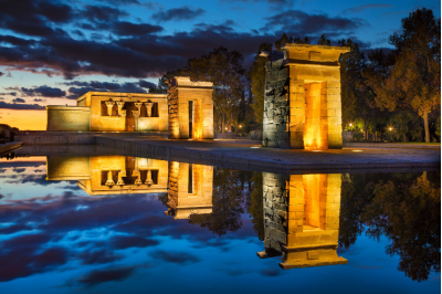
An authentic ancient Egyptian temple in the middle of Madrid might seem incongruous, but this 2nd-century BCE structure was gifted to Spain by Egypt in 1968 as thanks for Spanish assistance in saving antiquities threatened by the Aswan Dam project. Reassembled in Parque del Oeste, the temple offers both cultural interest and one of Madrid’s most spectacular sunset views over the city’s western horizon.
Connectivity:
Location and Historical Context
Official Name: Templo de Debod
Address: Paseo de Rosales, s/n, 28008 Madrid, Spain
Location: Oeste Park (Parque del Oeste), Madrid’s western district
Transportation Options
Metro (Subway) Access
- Closest Metro Stations:
- Ventura Rodríguez (Line 3): Most convenient station
- Plaza de España (Lines 3 and 10): Alternative route
- Moncloa (Lines 3 and 6): Additional option
Bus Transportation
- Recommended Bus Lines:
- Line 33: Direct route near the temple
- Line 65: Connects multiple central districts
- Line 121: Provides good coverage
- Line 202: Alternative route to the area
Parking Information
Nearby Parking Options
- Underground Parking Garages:
- Parking Plaza de España
- Parking Princesa
- Parking Ventura Rodríguez
- Nearby street parking with restricted zones
Visitor Information
Opening Hours
- Tuesday to Sunday: 10:00 AM – 8:00 PM (Summer)
- Tuesday to Sunday: 10:00 AM – 6:00 PM (Winter)
- Closed: Mondays
- Free Entry
Contact Information
- Managing Authority: Madrid City Council
- Phone: +34 914 66 41 60
- Official Tourism Website: www.esmadrid.com
- Email: informacion.turistica@madrid.es
- Social Media:
- Twitter: @TurismoMadrid
- Instagram: @madridciudad
Surrounding Attractions
- Oeste Park
- Royal Palace
- Princesa area
- Botanical Garden
- Scenic Madrid viewpoints
-
El Rastro Flea Market
Madrid’s largest and most famous open-air market has been operating since the medieval period. Every Sunday and public holiday, the La Latina neighborhood transforms as hundreds of stalls sell everything from antiques and collectibles to clothing and handcrafted items.
The surrounding streets fill with life as bars and cafés overflow with shoppers taking breaks from bargain hunting. For the most authentic experience, arrive early before the crowds become overwhelming.
Connectivity:
Location and Historical Context
Official Name: Mercado de El Rastro
Address: Plaza de Cascorro and surrounding streets in the La Latina neighborhood
Location: Historic Center of Madrid, primarily along Calle de la Ribera de Curtidores
Transportation Options
Metro (Subway) Access
- Closest Metro Stations:
- La Latina (Line 5): Most convenient station
- Tirso de Molina (Line 1): Alternative access point
- Anton Martin (Line 1): Another nearby option
Bus Transportation
- Recommended Bus Lines:
- Line 17: Directly serves the market area
- Line 35: Provides excellent coverage
- Line 50: Connects multiple districts
- Line 3: Alternative route near the market
Parking Information
Nearby Parking Options
- Underground Parking Garages:
- Parking Plaza de la Cebada
- Parking La Latina
- Parking Puerta de Toledo
- Parking Cascorro
Market Details
Opening Hours
- Every Sunday and Public Holidays: 9:00 AM – 3:00 PM
- Year-round weekly market
- Busiest times: 10:00 AM – 2:00 PM
Surrounding Attractions
- La Latina Neighborhood
- San Francisco el Grande Basilica
- Puerta de Toledo
- Madrid Río Park
- Medieval historic streets
Granada
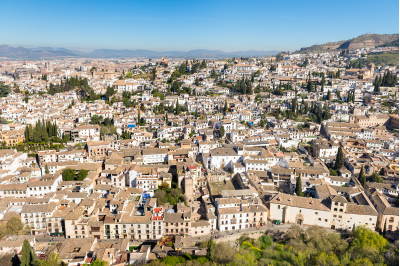
Granada, nestled in the foothills of Spain’s Sierra Nevada mountains in Andalusia, represents one of Spain’s most historically significant and architecturally stunning cities. The city’s unique position at the cultural crossroads between Islamic and Christian civilizations has created a rich tapestry of influences that manifest in its monuments, cuisine, and atmosphere.
-
The Alhambra

The Alhambra stands as the crown jewel of Granada and arguably one of the most magnificent architectural complexes in the world. This vast fortress-palace ensemble represents the pinnacle of Islamic art in Europe, constructed primarily during the Nasrid dynasty (13th-15th centuries).
What makes the Alhambra truly remarkable is its integration of architecture with its natural surroundings. The complex comprises several distinct sections: the Alcazaba (military fortress), the Nasrid Palaces, and the Generalife gardens. Within the Nasrid Palaces, visitors encounter spaces of breathtaking beauty—the Court of the Lions with its famous fountain, the Hall of the Ambassadors with its intricate geometric ceiling, and the Court of the Myrtles with its reflective pool that mirrors the surrounding architecture.
The delicate stucco work features Arabic calligraphy, primarily verses from the Quran and poetry, while the geometric patterns in the tilework demonstrate the mathematical sophistication of Islamic art. The clever use of water throughout—in fountains, channels, and pools—creates not only physical cooling but also produces soothing sounds and mesmerizing reflections that enhance the sensory experience.
Remember that tickets often sell out weeks in advance, so planning ahead is essential.
Connectivity:
Location and Historical Significance
Official Name: Alhambra Palace and Fortress Complex
Address: Calle Real de la Alhambra, s/n, 18009 Granada, Spain
Transportation Options to Granada and the Alhambra
Getting to Granada
By Train
- High-Speed Train (AVE):
- Direct connections from Madrid
- Journey time: Approximately 3.5 hours
- Terminus: Granada Train Station
- Regional Trains:
- Connections from major Spanish cities
- Operated by Renfe
Local Transportation in Granada
Bus Transportation
- Local Bus Routes:
- Line C30: Connects city center to the Alhambra
Parking at the Alhambra
- Official Parking Facilities:
- On-site parking available
- Limited spaces
- Recommended to book in advance
- Rates: Approximately €5-€10 per day
- Alternative Parking Options:
- Parking areas near the visitor center
- Street parking in nearby residential areas
- Public parking lots in Granada city center
Visitor Information
Opening Hours
- General Visits:
- Summer (April to September): 8:30 AM – 8:00 PM
- Winter (October to March): 8:30 AM – 6:00 PM
- Closed: Certain days during holidays
- Night Visits: Special evening tours available
Ticket Information
- Advance Booking Strongly Recommended
- Ticket Types:
- General Admission: €16-€25 (varies by season)
- Reduced Tickets: Students, seniors
- Free Entry: Children under 12, disabled visitors
Ticket Includes
- Access to Nasrid Palaces
- Alcazaba Fortress
- Generalife Gardens
- Charles V Palace
- Museum exhibits
Contact Information
- Official Website: www.alhambra-patronato.es
- Ticket Reservations: +34 958 02 79 71
- Tourist Information: +34 958 22 59 01
- Email: info.alhambra@juntadeandalucia.es
Nearby Attractions
- Albaicín Neighborhood
- Granada Cathedral
- Royal Chapel
- Generalife Gardens
- Sierra Nevada Mountains
-
The Albaicín Quarter
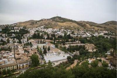
Directly across from the Alhambra lies the ancient Moorish quarter of Albaicín, a UNESCO World Heritage site that preserves the medieval Islamic urban design. Walking through this labyrinthine neighborhood feels like stepping back in time, with its narrow, winding cobblestone streets, white-washed houses, and hidden carmenes (traditional houses with walled gardens).
The quarter’s intricate network of streets evolved organically over centuries, designed to provide shade during hot summers and protection from cold winds in winter. Many homes feature traditional elements like interior courtyards with fountains—architectural solutions perfectly adapted to Granada’s climate.
The most magical spot in the Albaicín is undoubtedly the San Nicolás viewpoint (Mirador de San Nicolás), which offers the most iconic panorama of the Alhambra set against the backdrop of the Sierra Nevada mountains. Watching the sunset here, as the Alhambra’s walls gradually transform from golden to deep red in the changing light, creates an unforgettable memory.
Connectivity:
Location
Official Name: Barrio del Albaicín (Albaicín Neighborhood)
Location: Historic Quarter of Granada, Northern Hill Facing the Alhambra
Public Transportation
Metro
- Metro Stations:
- Limited metro system in Granada
- Closest station: Méndez Núñez
- Requires additional bus or walking connection
Bus Transportation
- Recommended Bus Lines:
- Line C1: Connects city center to Albaicín
- Line C2: Alternative route
- Line C30: Serves the historic area
- Frequent service throughout the day
Parking Considerations
- Parking Options:
- Limited street parking
- Public parking lots:
- Parking near Plaza Nueva
- Parking near Carrera del Darro
- Recommended strategies:
- Park in city center and walk
- Use public transportation
- Take a taxi
Visitor Information
Must-See Locations
- Mirador de San Nicolás
- Panoramic views of Alhambra
- Perfect sunset location
- Street musicians often perform
- Historic Churches:
- Iglesia de San Salvador
- Iglesia de Santa Ana
- Historic Carmens (Traditional Houses)
- Moorish-style homes with interior gardens
- Some open for guided tours
Cultural Experiences
Architectural Highlights
- Moorish Urban Design
- Narrow, winding streets
- Whitewashed houses
- Hidden plazas
- Intricate street patterns
Cultural Sites
- Moorish fountains
- Traditional tea houses
- Artisan workshops
- Street art and graffiti
- Local craft markets
Nearby Attractions
- Alhambra Palace
- Generalife Gardens
- Granada Cathedral
- Royal Chapel
- Carrera del Darro
- Plaza Nueva
-
The Cathedral and Royal Chapel
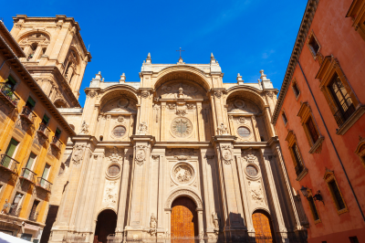
Granada’s Cathedral represents one of Spain’s masterpieces of Spanish Renaissance architecture, begun in 1518 shortly after the Christian reconquest. The imposing structure features a spectacular façade designed by Alonso Cano and a soaring interior with massive columns.
Adjacent to the Cathedral lies the Royal Chapel (Capilla Real), commissioned by Catholic Monarchs Ferdinand and Isabella as their final resting place. Their ornate marble tombs lie within, symbolizing the culmination of the Reconquista and the unification of Spain. The sacristy houses a small but impressive museum containing Queen Isabella’s personal art collection, including works by Flemish and Italian masters.
What makes this complex particularly fascinating is how it embodies Spain’s transition from medieval to Renaissance ideals, built literally upon the foundations of the city’s former main mosque—a physical manifestation of the cultural transformation that Granada underwent in the 16th century.
Location and Historical Significance
Official Name:
- Cathedral of the Incarnation (Catedral de la Encarnación)
- Royal Chapel (Capilla Real)
Address:
- Cathedral: Plaza de la Catedral, s/n, 18001 Granada, Spain
- Royal Chapel: Calle Oficios, s/n, 18001 Granada, Spain
Transportation Options
Metro
- Closest Metro Stations:
- Méndez Núñez Station
- Limited metro system in Granada
- Requires additional walking or bus connection
Bus Transportation
- Recommended Bus Lines:
- Line C1: Serves city center
- Line C2: Connects key historic areas
- Line C30: Stops near cathedral
Parking Considerations
- Parking Options:
- Limited street parking
- Nearby Public Parking:
- Plaza Nueva Parking
- Parking near Carrera del Darro
- Underground parking in city center
Visitor Information
Opening Hours
Cathedral
- Summer (April to September):
- Monday to Saturday: 10:30 AM – 6:30 PM
- Sunday: 1:30 PM – 6:30 PM
- Winter (October to March):
- Monday to Saturday: 10:30 AM – 5:30 PM
- Sunday: 1:30 PM – 5:30 PM
Royal Chapel
- Summer (April to September):
- Monday to Saturday: 10:30 AM – 6:30 PM
- Sunday: 11:00 AM – 6:30 PM
- Winter (October to March):
- Monday to Saturday: 10:30 AM – 5:30 PM
- Sunday: 11:00 AM – 5:30 PM
Ticket Information
- Combined Ticket (Cathedral and Royal Chapel):
- Adults: €5-€7 (varies by season)
- Reduced: Students, seniors
- Free: Children under 12, disabled visitors
What’s Included
- Full access to cathedral interior
- Royal Chapel museum
- Tombs of Catholic Monarchs
- Audio guide (multiple languages)
- Guided tour options
Contact Information
- Cathedral Office:
- Phone: +34 958 22 29 59
- Email: secretaria@diocesisgranada.es
- Tourism Information:
- Phone: +34 958 24 71 40
- Website: www.granadatur.com
- Email: turismo@granada.org
Nearby Attractions
- Albaicín Quarter
- Alhambra Palace
- Generalife Gardens
- Plaza Nueva
- Granada City Center
-
Sacromonte
Perched on the hillside adjacent to the Albaicín, Sacromonte represents the traditional home of Granada’s Roma (Gypsy) community. The area is famous for its cave dwellings carved into the soft rock of the hillside, many of which have been converted into flamenco venues called zambras.
These caves originally served as simple dwellings for marginalized communities but evolved into centers for preserving and developing the art of flamenco. The Sacromonte style of flamenco has distinctive characteristics, including unique dance forms like the zambra gitana, which bears traces of the Moorish zambra dance that predated the Christian reconquest.
Watching an authentic flamenco performance in one of these intimate cave settings provides insight into how this passionate art form evolved as an expression of both suffering and resilience. The Museum of Sacromonte Caves offers a fascinating glimpse into the traditional way of life in this unique community.
Location
Neighborhood: Sacromonte
Location: Northeastern hill of Granada, adjacent to the Albaicín Quarter
Transportation Options
Bus Routes
- Recommended Bus Lines:
- Line C1: Connects city center to Sacromonte
- Line C2: Alternative route through historic areas
- Line C30: Serves the neighborhood and nearby attractions
Parking Considerations
- Parking Options:
- Limited street parking
- Recommended Parking Strategies:
- Park in Granada city center
- Use public transportation or taxi
- Some designated parking areas near Sacromonte Abbey
Visitor Information
Key Attractions
- Cave Dwellings
- Traditional Roma cave homes
- Some converted to museums
- Some still inhabited by local families
- Sacromonte Abbey
- Historical religious site
- Museum of local history
- Panoramic views of Granada
- Flamenco Caves
- Traditional performance venues
- Authentic cultural experiences
- Evening shows featuring local artists
Contact Information
- Granada Tourist Office:
- Phone: +34 958 24 71 40
- Website: www.granadatur.com
- Email: turismo@granada.org
- Sacromonte Cultural Center:
- Phone: +34 958 22 51 42
- Email: info@sacromontegranada.com
Nearby Attractions
- Alhambra Palace
- Albaicín Quarter
- Granada Cathedral
- Darro River Valley
- Generalife Gardens
-
Carrera del Darro and Paseo de los Tristes
The Darro River winds through Granada at the foot of the Alhambra hill, and along its banks runs one of Europe’s most picturesque streets—the Carrera del Darro. This ancient cobblestone pathway follows the course of the river beneath old stone bridges, passing historical buildings like the 11th-century El Bañuelo (Arab baths) and the Renaissance-era Casa de Castril.
The street eventually opens onto the Paseo de los Tristes (Walk of the Sad Ones), named for funeral processions that once passed through on their way to the cemetery. Despite this somber name, the area now buzzes with life, hosting numerous cafés and restaurants where visitors can relax with spectacular views of the Alhambra looming above.
The unique charm of this area lies in how it demonstrates Granada’s layered history—Roman bridges, Moorish architecture, Renaissance palaces, and modern cafés coexisting in a single harmonious vista. The location also provides a perfect perspective for understanding Granada’s strategic position, nestled between rivers and hills that made it both defensible and agriculturally productive.
Location Overview
Address: Carrera del Darro, 18010 Granada, Spain
Neighborhood: Albaicín (UNESCO World Heritage Site)
Transportation Options
- Bus Routes
- Line C1: Connects Plaza Nueva to the Albaicín area
- Line C2: Serves the historic city center
- Stop Closest to Location: “Plaza Nueva” or “Carrera del Darro”
- Taxi Services
- Multiple taxi stands in downtown Granada
- Average fare from city center: €8-12
- Recommended taxi companies:
- Radio Taxi Granada: +34 958 280 000
- Tele Taxi Granada: +34 958 270 000
Parking Options
- Nearby Public Parking Lots
- Parking Plaza Nueva
- Capacity: 300 spaces
- Underground parking
- Operating Hours: 24/7
- Rates: €2.50/hour, €20/day
- Parking Plaza Nueva
- Street Parking
- Limited regulated street parking
- Blue Zone (Zona Azul) restrictions apply
- Maximum parking duration: 2 hours
- Parking meters required
Nearby Attractions
- Alhambra Palace (0.5 km)
- Granada Cathedral (0.3 km)
- Royal Chapel (0.4 km)
- Albaicín Neighborhood
- Mirador de San Nicolás
Seville
Seville, the capital of Andalusia, represents the cultural heart of southern Spain. This city’s remarkable historical significance stems from its position as a major trading port during Spain’s Golden Age and its role as the gateway to the Americas after Columbus’s voyages.
What makes Seville particularly fascinating is how multiple civilizations—Roman, Visigothic, Islamic, and Christian—have each left their distinct architectural and cultural imprints, creating a city of extraordinary depth and character. Let me guide you through the five most essential sites that will provide you with a comprehensive understanding of Seville’s multifaceted identity.
-
The Seville Cathedral and La Giralda

The Seville Cathedral stands as the largest Gothic cathedral in the world and the third-largest church overall. What many visitors don’t initially realize is that this massive structure was deliberately built to demonstrate Christian power, constructed directly atop the site of the city’s former grand mosque after the Reconquista. The cathedral’s builders reportedly aimed to create something so magnificent that “future generations would think them mad.”
The most fascinating aspect of this complex is La Giralda, the bell tower that was originally the minaret of the mosque. Rather than destroying this Islamic architectural masterpiece, the Christians incorporated it into their cathedral, adding Renaissance elements to its top. This architectural palimpsest perfectly encapsulates Seville’s layered history. The tower’s internal structure features ramps rather than stairs, designed so that muezzins could ride horseback to the top to issue the call to prayer.
Inside the cathedral, you’ll find Christopher Columbus’s elaborate tomb, carried by figures representing the four kingdoms of Spain. The treasury houses an extraordinary collection of religious art, including works by Murillo and Goya. The Capilla Mayor (main chapel) features the largest altarpiece in the world, containing over 1,000 carved biblical figures covered in gold leaf—a testament to the wealth flowing into Spain from the Americas during the 16th century.
Location and Address
Address: Avenida de la Constitución, s/n, 41004 Sevilla, Spain
Transportation Options
- Metro
- Nearest Metro Station: Puerta de Jerez (Line 1)
- Distance from station: Approximately 5-10 minutes walking
- Bus
- Multiple bus lines serve the area:
- Lines C1, C2, and C4 stop near the cathedral
- Lines 3, 5, 6, 7, and 10 also provide convenient access
- Multiple bus lines serve the area:
- Tram
- MetroCentro Line connects major points in the city center
- Stops near the cathedral at Plaza Nueva
Parking Options
- Nearby Parking Garages
- Parking Plaza Nueva
- Address: Plaza Nueva, s/n
- Capacity: Approximately 400 spaces
- Open 24/7
- Rates: Varies by duration (typically €2-4 per hour)
- Parking Plaza Nueva
Visiting Details
Opening Hours
- Summer (April to September)
- Monday to Saturday: 10:30 AM – 5:00 PM
- Sunday: 2:30 PM – 6:00 PM
- Winter (October to March)
- Monday to Saturday: 11:00 AM – 5:00 PM
- Sunday: 2:30 PM – 6:00 PM
Ticket Information
- Admission Prices
- Adult: €10
- Reduced (students, seniors): €5
- Children under 12: Free
- Ticket Types
- General Cathedral Entry
- Cathedral + Tower (La Giralda) Access
- Combined ticket with Royal Alcázar
Contact Information
- Phone: +34 954 21 49 71
- Email: reservas@catedraldesevilla.es
- Website: www.catedraldesevilla.es
Nearby Attractions
- Royal Alcázar of Seville
- Plaza de España
- Torre del Oro
- Archive of the Indies
-
Real Alcázar

The Real Alcázar represents one of the world’s most outstanding examples of Mudéjar architecture—a style developed by Muslims working under Christian rule that blends Islamic artistic elements with European Christian influences. What makes this palace complex truly extraordinary is that it remains Europe’s oldest royal residence still in use, with the Spanish royal family occupying the upper levels when visiting Seville.
The palace evolved over nearly a millennium, with each successive ruler adding their own architectural contributions. The heart of the complex is the Palace of Pedro I, built in the 14th century by a Christian king who, paradoxically, employed Muslim artisans to create an Islamic-style palace more magnificent than those of his Muslim rivals in Granada. The resulting spaces—particularly the breathtaking Courtyard of the Maidens with its reflecting pool—demonstrate how cultural exchange often transcended religious and political boundaries.
The gardens of the Alcázar deserve special attention. They combine formal Renaissance designs with Islamic water features and incorporate plants from the Americas—a horticultural record of Spain’s imperial connections. The hydraulic systems that feed the numerous fountains and pools represent sophisticated engineering knowledge transmitted from Islamic civilization.
Location and Address
Address: Patio de Banderas, s/n, 41004 Sevilla, Spain
Transportation Options
- Metro
- Nearest Metro Station: Puerta de Jerez (Line 1)
- Distance from station: Approximately 10-15 minutes walking
- Bus
- Convenient bus lines:
- Line C1: Connects major tourist areas
- Lines 3, 5, 6, 7, and 10: Provide access to the city center
- Stops near Plaza del Triunfo and Avenida de la Constitución
- Convenient bus lines:
- Tram
- MetroCentro Line serves the historic city center
- Stops near Plaza Nueva, a short walk from the Alcázar
Parking Options
- Nearby Parking Garages
- Parking Plaza Nueva
- Address: Plaza Nueva, s/n
- Capacity: Approximately 400 spaces
- Open 24/7
- Rates: €2-4 per hour
- Parking Plaza Nueva
Visiting Details
Opening Hours
- Summer (April to September)
- Monday to Sunday: 9:30 AM – 7:00 PM
- Last entry: 6:00 PM
- Winter (October to March)
- Monday to Sunday: 9:30 AM – 5:00 PM
- Last entry: 4:00 PM
Ticket Information
- Admission Prices
- Adult: €14.50
- Reduced (students, seniors): €7.25
- Children under 12: Free
- Ticket Types
- General Alcázar Entry
- Guided Tour
- Combined ticket with Cathedral
Contact Information
- Phone: +34 954 50 23 24
- Email: reservas@realcazardesevilla.org
- Website: www.realcazardesevilla.org
Nearby Attractions
- Seville Cathedral
- La Giralda Tower
- Plaza de España
- Archive of the Indies
-
Plaza de España
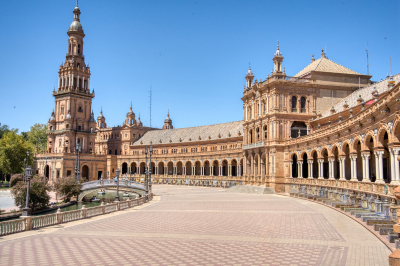
Built for the Ibero-American Exposition of 1929, the Plaza de España represents an architectural love letter to Spain’s diverse regions and its historical connections to its former colonies. The massive semi-circular complex combines elements of Renaissance Revival, Art Deco, and Neo-Mudéjar styles, creating a uniquely Spanish architectural statement.
What makes this plaza particularly special are the 48 alcoves along its curved wall, each dedicated to a different Spanish province and decorated with painted ceramic tiles (azulejos) depicting historical scenes from that region. These vibrant ceramic depictions serve as a national atlas and historical encyclopedia, inviting visitors to learn about Spain’s regional diversity.
The canal that runs through the plaza, crossed by four bridges representing the ancient kingdoms of Spain, allows visitors to rent small boats—a romantic touch inspired by Venice but reinterpreted in a distinctly Spanish manner. The Plaza exemplifies Spain’s early 20th-century efforts to redefine its national identity following the loss of its last colonies while celebrating its cultural heritage.
Location and Address
Address: Plaza de España, s/n, 41013 Sevilla, Spain
Location: Maria Luisa Park (Parque de María Luisa)
Transportation Options
- Metro
- Nearest Metro Station: Plaza de Cuba (Line 1)
- Distance from station: Approximately 15-20 minutes walking
- Alternative: Puerta de Jerez Station
- Bus
- Convenient bus lines:
- C1, C2: Direct routes to Maria Luisa Park
- Lines 3, 5, 6, 7, 10: Provide access to the area
- Specific stops:
- Plaza de Cuba
- Avda. María Luisa
- Paseo de las Delicias
- Convenient bus lines:
- Tram
- MetroCentro Line serves the city center
- Closest stop: Plaza Nueva
- Short walk through the historic center
Parking Options
- Nearby Parking Garages
- Parking Plaza Nueva
- Address: Plaza Nueva, s/n
- Capacity: Approximately 400 spaces
- Open 24/7
- Rates: €2-4 per hour
- Parking near Maria Luisa Park
- Underground parking facilities
- Multiple options within walking distance
- Parking Plaza Nueva
Visiting Details
Access and Hours
- Open to Public
- 24 hours a day
- Free entry to the plaza and surrounding park areas
Nearby Attractions
- Royal Alcázar of Seville
- Seville Cathedral
- Torre del Oro
- Archaeological Museum of Seville
Contact and More Information
- Tourist Information
- Seville Tourist Office
- Phone: +34 954 22 14 04
- Website: www.visitasevilla.es
-
Barrio Santa Cruz

The former Jewish quarter of Seville, Barrio Santa Cruz, presents a fascinating window into medieval urban design. Following the Christian reconquest and subsequent persecution of Jews, this neighborhood underwent significant transformations, yet it retains the intimate scale and organic layout characteristic of medieval Mediterranean cities.
What makes Santa Cruz particularly enchanting is how practical solutions to Seville’s intense climate created spaces of remarkable beauty. The narrow, winding streets—so tight in places that they’re called “kissing lanes” because balconies nearly touch across them—were designed to provide shade during scorching summers. Small plazas with orange trees and fountains create microclimate cooling effects. Whitewashed walls reflect sunlight while interior courtyards (patios) hidden behind ornate iron gates provide private garden retreats.
This neighborhood contains numerous important historical sites, including the Hospital de los Venerables, originally built to care for elderly priests and now housing an important art collection. However, the greatest pleasure comes from wandering without a strict itinerary, discovering hidden squares like Plaza de Doña Elvira with its tiled benches and fragrant orange trees, or stumbling upon small churches containing unexpected artistic treasures.
Location and Historical Context
Area: Historic Jewish Quarter of Seville
Geographical Boundaries:
- North: Calle Alemanes
- South: Plaza de la Virgen de los Reyes
- East: Seville Cathedral
- West: Royal Alcázar
Transportation Options
- Metro
-
- Nearest Metro Stations:
- Puerta de Jerez (Line 1)
- Plaza de Cuba (Line 1)
- Walking distance: 10-15 minutes from both stations
- Nearest Metro Stations:
- Bus
- Convenient bus lines serving the area:
- C1, C2: Connects major tourist attractions
- Lines 3, 5, 6, 7, 10: Provide extensive city center coverage
- Stops near:
- Plaza de la Virgen de los Reyes
- Avenida de la Constitución
- Convenient bus lines serving the area:
- Tram
- MetroCentro Line
- Stops near:
- Plaza Nueva
- Cathedral area
Parking Options
- Nearby Parking Garages
- Parking Plaza Nueva
- Address: Plaza Nueva, s/n
- Capacity: 400 spaces
- Open 24/7
- Rates: €2-4 per hour
- Underground Parking near Cathedral
- Multiple facilities within walking distance
- Rates vary (€2-5 per hour)
- Parking Plaza Nueva
Nearby Attractions
- Royal Alcázar
- Seville Cathedral
- Plaza de España
- Torre del Oro
-
The Metropol Parasol (Las Setas)
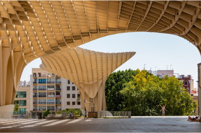
Completed in 2011 and commonly known as “Las Setas” (The Mushrooms) due to its distinctive form, the Metropol Parasol provides a contemporary counterpoint to Seville’s historical architecture. This massive wooden structure—claimed to be the largest wooden building in the world—consists of six parasol-shaped forms that create shade over the Plaza de la Encarnación.
What makes this modern intervention particularly significant is how it bridges Seville’s ancient past with its future. The structure was built above an archaeological site containing Roman and Moorish ruins, which are preserved and displayed in an underground museum. The architects solved the challenge of protecting these ruins while creating a vibrant new public space that has revitalized a formerly declining neighborhood.
The elevated walkway that winds across the top of the structure offers spectacular panoramic views of Seville’s historical center, allowing visitors to comprehend the urban layout and architectural relationships between the city’s major monuments. This bird’s-eye perspective reveals patterns of development that shaped the city over centuries, from Roman grid planning to medieval organic growth.
Location and Architectural Marvel
Address: Plaza de la Encarnación, s/n, 41003 Sevilla, Spain
Architect: Jürgen Mayer Hermann Completed: 2011
Transportation Options
- Metro
- Nearest Metro Station: Plaza de la Encarnación (Line 1)
- Walking Distance: Immediate access
- Travel Time from City Center: 5-10 minutes
- Bus
- Convenient Bus Lines:
- C1, C2: Direct routes to city center
- Lines 3, 5, 6, 7, 10: Comprehensive city coverage
- Specific Stops:
- Plaza de la Encarnación
- Avenida de la Constitución
- Convenient Bus Lines:
- Tram
- MetroCentro Line
- Closest Stop: Plaza Nueva
- Short walking distance (10-15 minutes)
Parking Options
- Nearby Parking Facilities
- Underground Parking at Plaza de la Encarnación
- Capacity: Approximately 300 spaces
- Open 24/7
- Rates: €2-4 per hour
- Additional Nearby Parking:
- Parking Plaza Nueva
- Multiple underground parking facilities in historic center
- Underground Parking at Plaza de la Encarnación
Visiting Details
Opening Hours
- Observation Deck and Museum
- Summer (April to September):
- Monday to Sunday: 10:00 AM – 11:00 PM
- Last entry: 10:30 PM
- Winter (October to March):
- Monday to Sunday: 10:00 AM – 8:00 PM
- Last entry: 7:30 PM
- Summer (April to September):
Ticket Information
- Admission Prices
- Adult: €8
- Reduced (students, seniors): €4
- Children under 12: Free
- Ticket Types
- Observation Deck Access
- Museum and Archaeological Site
- Combined Ticket with Panoramic Walk
Contact Information
- Phone: +34 954 56 16 30
- Email: info@metropolparasol.com
- Website: www.metropolparasol.com
Nearby Attractions
- Seville Cathedral
- Royal Alcázar
- Barrio Santa Cruz
- Plaza de España
Valencia

Valencia, Spain’s third-largest city, offers a wonderful blend of historic architecture, modern design, beautiful beaches, and rich cultural experiences.
-
City of Arts and Sciences (Ciudad de las Artes y las Ciencias)

This futuristic architectural complex is Valencia’s most distinctive landmark. Designed by Santiago Calatrava and Félix Candela, it stretches along what was once the riverbed of the Turia River. The complex includes several striking buildings:
- The Hemisfèric: A planetarium and IMAX cinema shaped like a giant eye
- The Oceanogràfic: Europe’s largest aquarium with different marine environments
- The Príncipe Felipe Science Museum: A hands-on science center with interactive exhibits
- The Palau de les Arts Reina Sofía: An opera house and performing arts center
- The Umbracle: An open-air garden with indigenous plants and contemporary sculptures
The contrast between these ultra-modern structures and Valencia’s historic center illustrates the city’s evolution from ancient Roman settlement to forward-thinking Mediterranean metropolis.
Location and Overview
Address: Avinguda del Professor López Piñero (Arquitecto Calatrava), 7, 46013 Valencia, Spain
Architect: Santiago Calatrava and Félix Candela Established: 1998-2005
Transportation Options
- Metro
- Nearest Metro Stations:
- Transparent Blue Line (Line 4):
- Alameda Station
- Doctor Waksman Station
- Walking distance: 10-15 minutes
- Frequent trains connecting to city center
- Transparent Blue Line (Line 4):
- Nearest Metro Stations:
- Bus
- Convenient Bus Lines:
- Line 1: Direct route to City of Arts and Sciences
- Lines 18, 95, 99: Provide comprehensive coverage
- Specific Stops:
- Ciudad de las Artes y las Ciencias
- Paseo de Valencia
- Convenient Bus Lines:
- Tram
- Line 8 (Metropolitano de Valencia)
- Stops near the complex
- Connects to city center and surrounding areas
Parking Options
- Parking Facilities
- Main Parking Area
- Underground parking beneath the complex
- Capacity: Approximately 500 spaces
- Rates: €1-3 per hour
- Open 24/7
- Additional Nearby Parking:
- Public parking lots in Turia Gardens
- Street parking with time restrictions
- Main Parking Area
Visiting Details
Opening Hours and Operating Times
Note: Hours vary for individual attractions within the complex
- General Complex
- Open daily
- Recommended visit times: 10:00 AM – 6:00 PM
- Specific Attractions
- L’Hemisfèric (IMAX Cinema and Planetarium)
- Shows: Multiple daily sessions
- First show: 11:00 AM
- Last show: 9:00 PM
- Oceanogràfic (Marine Park)
- Summer (April-September): 10:00 AM – 7:00 PM
- Winter (October-March): 10:00 AM – 6:00 PM
- Principe Felipe Science Museum
- Daily: 10:00 AM – 7:00 PM
- Extended hours during summer and holidays
- L’Hemisfèric (IMAX Cinema and Planetarium)
Ticket Information
- Comprehensive Ticket Options
- Full Complex Pass
- Adult: €45
- Children (4-12): €35
- Includes entry to all attractions
- Individual Attraction Tickets
- L’Hemisfèric: €8
- Oceanogràfic: €30
- Principe Felipe Science Museum: €8
- Full Complex Pass
Contact Information
- General Inquiries
- Phone: +34 902 10 00 31
- Email: info@cac.es
- Website: www.cac.es
Nearby Attractions
- Turia Gardens
- Valencia Cathedral
- Central Market of Valencia
- Historic City Center
Tourist Information
- Valencia Tourist Office
- Phone: +34 963 51 99 00
- Website: www.visitvalencia.com
-
Valencia Cathedral and El Miguelete
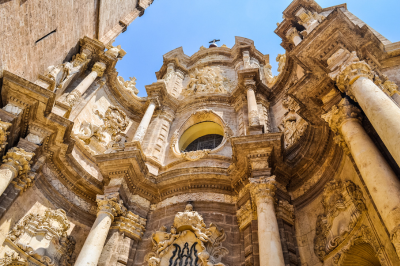
The Valencia Cathedral (Catedral de Valencia) dates primarily from the 13th to 15th centuries and blends Romanesque, Gothic, and Baroque architectural styles. The cathedral houses what many believe to be the Holy Grail—the chalice used by Jesus at the Last Supper.
El Miguelete, the cathedral’s bell tower, offers one of the best panoramic views of Valencia. Climbing its 207 steps rewards visitors with a spectacular vista of the historic center, the port, and on clear days, the surrounding mountains.
Location and Historical Significance
Address: Plaza de la Virgen, 1, 46001 Valencia, Spain
Historical Designation: Cathedral of Santa María la Mayor
Transportation Options
- Metro
- Nearest Metro Stations:
- Colón Station (Line 3, 5, 7, 9)
- Xàtiva Station (Line 3, 5, 7, 9)
- Walking Distance: 10-15 minutes
- Nearest Metro Stations:
- Bus
- Convenient Bus Lines:
- Lines 11, 17, 27, 64: Direct routes to historic center
- Stops near:
- Plaza de la Virgen
- Plaza de la Reina
- Convenient Bus Lines:
- Tram
- MetroValencia Tram Lines
- Closest Stops:
- Colón
- Xàtiva
- Short walking distance to cathedral
Parking Options
- Underground Parking Facilities
- Parking Plaza de la Virgen
- Capacity: Approximately 300 spaces
- Rates: €2-4 per hour
- 24/7 access
- Parking Plaza de la Reina
- Capacity: 250 spaces
- Rates: €2-3 per hour
- Convenient location
- Parking Plaza de la Virgen
- Street Parking
- Limited availability
- Strictly regulated
- Metered zones with time restrictions
- Recommended to use underground parking
Visiting Details
Opening Hours
- Cathedral
- Summer (April to September):
- Monday to Saturday: 10:00 AM – 6:30 PM
- Sunday: 2:00 PM – 6:30 PM
- Winter (October to March):
- Monday to Saturday: 10:00 AM – 5:30 PM
- Sunday: 2:00 PM – 5:30 PM
- Summer (April to September):
- El Miguelete Tower
- Guided Tours:
- Tuesday to Saturday: 10:30 AM, 11:30 AM, 12:30 PM
- Limited daily access
- Advance booking recommended
- Guided Tours:
Ticket Information
- Admission Prices
- Cathedral Entry:
- Adults: €7
- Reduced (students, seniors): €4
- Children under 12: Free
- El Miguelete Tower:
- Additional €2 to cathedral ticket
- Limited to 8 people per tour
- Physical fitness required (curved stairs)
- Cathedral Entry:
Contact Information
- Cathedral Office
- Phone: +34 963 91 81 27
- Email: reservas@catedraldevalencia.es
- Website: www.catedraldevalencia.es
Nearby Attractions
- Central Market of Valencia
- Silk Exchange (La Lonja)
- Plaza de la Virgen
- Royal Gardens (Jardines del Real)
-
Mercado Central (Central Market)

One of Europe’s oldest and largest fresh food markets, the Mercado Central is housed in a stunning modernist building completed in 1928. With its stained glass, domes, and intricate ironwork, it’s an architectural marvel even before you consider what’s inside.
The market contains nearly 400 stalls selling everything from fresh seafood and produce to local specialties like horchata (a sweet tiger nut milk) and jamón ibérico. It provides a perfect opportunity to experience local culture and sample authentic Valencian cuisine. The vibrant colors, aromas, and sounds make it a feast for all senses.
Location
Address: Plaza del Mercado, 1, 46001 Valencia, Spain
Architectural Style: Modernist (Modernisme)
Year Built: 1928
Architectural Designers: Francesc de Paula Goerlich Lleó
Cultural Status: National Historic Monument
Transportation Options
- Metro
-
- Nearest Metro Stations:
- Colón Station (Lines 3, 5, 7, 9)
- Xàtiva Station (Lines 3, 5, 7, 9)
- Walking Distance: 5-10 minutes
- Nearest Metro Stations:
- Bus
- Convenient Bus Lines:
- Lines 11, 17, 27, 64: Direct routes to historic center
- Stops near:
- Plaza del Mercado
- Plaza de la Reina
- City Hall
- Convenient Bus Lines:
- Tram
- MetroValencia Tram Lines
- Closest Stops:
- Colón
- Xàtiva
- Short walking distance to market
Parking Options
- Underground Parking Facilities
- Parking Plaza del Mercado
- Capacity: Approximately 250 spaces
- Rates: €2-3 per hour
- 24/7 access
- Parking Plaza de la Reina
- Capacity: 250 spaces
- Rates: €2-3 per hour
- Convenient location
- Parking Plaza del Mercado
Visiting Details
Opening Hours
- Market Operations
- Monday to Saturday: 7:30 AM – 3:00 PM
- Closed on Sundays and public holidays
Contact Information
- Market Administration
- Phone: +34 963 52 54 78
- Email: info@mercadocentralvalencia.es
- Website: www.mercadocentralvalencia.es
Nearby Attractions
- Valencia Cathedral
- Silk Exchange (La Lonja)
- Plaza de la Virgen
- Central Historic District
-
Jardín del Turia (Turia Gardens)
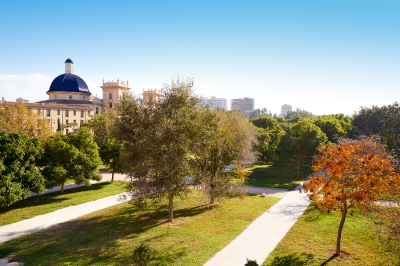
After a devastating flood in 1957, Valencia diverted the Turia River and transformed the old riverbed into a 9-kilometer park that winds through the city. This urban garden is now a verdant oasis where locals exercise, picnic, and relax.
The park features athletic fields, playgrounds, cycling paths, fountains, and ponds. As you stroll through, you’ll pass under 18 bridges that once spanned the river, each with its own architectural style. The contrast between these historic bridges and the lush garden setting creates a uniquely Valencian experience.
Location and Geographical Details
Address: Extends from the Bioparc to the City of Arts and Sciences
Location: Runs through the center of Valencia, Spain
Transportation Options
- Metro
- Multiple Access Points Along the Gardens:
- Colón Station (Lines 3, 5, 7, 9)
- Xàtiva Station (Lines 3, 5, 7, 9)
- Túria Station (Line 5)
- Walking Distance: Direct access from multiple stations
- Multiple Access Points Along the Gardens:
- Bus
- Convenient Bus Lines:
- Lines 11, 17, 27, 64: Connect various points along the gardens
- Multiple stops along the route
- Convenient Bus Lines:
- Tram
- MetroValencia Tram Lines
- Multiple Access Points:
- Colón
- Xàtiva
- Near major attractions along the gardens
Parking Options
- Parking Facilities Near Garden Sections
- Underground Parking Near City of Arts and Sciences
- Capacity: Approximately 500 spaces
- Rates: €2-4 per hour
- 24/7 access
- Parking Near Bioparc
- Capacity: 250 spaces
- Rates: €2-3 per hour
- Underground Parking Near City of Arts and Sciences
Visiting Details
Accessibility and Hours
- Garden Access
- Open 24 hours a day
- Free public access
- Well-lit sections during evening hours
Garden Sections and Features
- Ecological Diversity
- Native Mediterranean plant species
- Diverse landscaping
- Multiple recreational zones
- Sports facilities
- Children’s playgrounds
- Major Sections
- Bioparc Section
- City of Arts and Sciences Section
- Historic City Center Section
- Sports and Recreation Areas
- Botanical Gardens
Recreational Opportunities
- Cycling paths
- Running tracks
- Skateboarding areas
- Outdoor exercise equipment
- Picnic zones
- Children’s playgrounds
- Sports courts
Nearby Attractions
- City of Arts and Sciences
- Bioparc Valencia
- Valencia Cathedral
- Central Market
- Historic City Center
-
La Lonja de la Seda (Silk Exchange)
This 15th-century building, declared a UNESCO World Heritage Site in 1996, represents the golden age of Valencia when it was one of Europe’s major silk trading centers. La Lonja is considered a masterpiece of late Gothic civil architecture.
The main hall, known as the Contract Hall or Hall of Columns, features twisted columns that soar upward like palm trees. The intricate stone carvings, some humorous and others grotesque, showcase the craftsmanship of medieval stonemasons. Adjacent rooms include the Maritime Consulate and the upper floor, which once housed the Tribunal del Mar (Maritime Tribunal).
Location and Architectural Details
Address: Plaça del Mercat, 2, 46001 Valencia, Spain
Constructed: 1482-1498
Architect: Pere Compte
Transportation Options
Public Transportation
- Metro
- Nearest Metro Stations:
- Colón Station (Lines 3, 5, 7, 9)
- Xàtiva Station (Lines 3, 5, 7, 9)
- Walking Distance: 5-10 minutes
- Nearest Metro Stations:
- Bus
- Convenient Bus Lines:
- Lines 11, 17, 27, 64: Direct routes to historic center
- Stops near:
- Plaza del Mercado
- City Hall
- Central Market
- Convenient Bus Lines:
- Tram
- MetroValencia Tram Lines
- Closest Stops:
- Colón
- Xàtiva
- Short walking distance to La Lonja
Parking Options
- Underground Parking Facilities
- Parking Plaza del Mercado
- Capacity: Approximately 250 spaces
- Rates: €2-3 per hour
- 24/7 access
- Parking Plaza de la Reina
- Capacity: 250 spaces
- Rates: €2-3 per hour
- Convenient location
- Parking Plaza del Mercado
Visiting Details
Opening Hours
- Museum and Monument
- Tuesday to Saturday: 10:00 AM – 7:00 PM
- Sunday: 10:00 AM – 2:00 PM
- Closed on Mondays
- Last entry: 30 minutes before closing
Ticket Information
- Admission Prices
- General Entry: €2
- Reduced (students, seniors): €1
- Children under 12: Free
- Guided Tours: Additional €3
Contact Information
- Museum Administration
- Phone: +34 963 52 54 78
- Email: info@lalotja-valencia.es
- Website: www.lalotja-valencia.es
Architectural and Historical Highlights
Building Sections
- Main Trading Hall (Sala de Contratación)
- Gothic hall with twisted columns
- Symbolizes commercial power
- Intricate architectural details
- Represents medieval trading practices
- Towers and External Architecture
- Defensive architectural elements
- Ornate Gothic decorative features
- Symbolic representations of commercial strength
Nearby Attractions
- Central Market
- Valencia Cathedral
- Plaza de la Virgen
- Historic City Center
San Sebastián
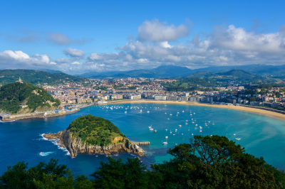
San Sebastián (Donostia in Basque) represents one of Spain’s most captivating cultural and culinary destinations. To truly understand this elegant coastal city, we need to explore how its geography, history, and culture have intertwined to create a uniquely Basque experience that goes far beyond typical tourism.
For more details visit: https://www.sansebastianturismoa.eus/en/
-
La Concha Beach (Playa de la Concha)

La Concha Beach derives its name from its distinctive shell-like shape and stands as one of Europe’s most beautiful urban beaches. What makes this beach extraordinary isn’t just its aesthetic appeal but how it functions as the heart of San Sebastián’s social fabric.
Unlike many coastal cities where beaches exist as separate entities from urban centers, La Concha seamlessly integrates with the city itself. The elegant Belle Époque promenade that runs along its edge was developed during the late 19th century when Spanish royalty chose San Sebastián as their summer retreat. This historical choice transformed what was once a fishing town into a sophisticated resort destination.
When you stand on La Concha, you’re experiencing the result of deliberate urban planning that preserved public access to natural beauty while developing a dignified architectural identity. The white railings along the promenade have become iconic symbols of the city, featured in countless photographs. These railings were designed by Juan Rafael Alday in 1910 and represent the city’s commitment to thoughtful design even in its most functional elements.
The beach itself experiences significant tidal variations, sometimes losing up to 40 meters of sand during high tide. This natural rhythm creates different experiences throughout the day—from extensive sandy expanses to intimate swimming areas. The relatively calm waters result from the bay’s protective geography, which shields swimmers from the often rough Bay of Biscay.
Location and Address
Address: Paseo de la Concha, s/n, 20007 San Sebastián (Donostia), Gipuzkoa, Spain
Transportation Options
- Bus
-
- Local Bus Lines: Several San Sebastian city buses stop near the beach
- Lines 5, 6, and 9 have stops close to the beach promenade
- Donostia Bus Station is approximately 1 km from the beach
- Local Bus Lines: Several San Sebastian city buses stop near the beach
- Train
- Nearest Train Stations:
- Amara RENFE Station: 1.5 km from the beach
- Donostia-San Sebastian Station: 2 km from the beach
- Both stations offer connections to regional and national train networks
- Nearest Train Stations:
- Tram
- Euskotren (Local Tram System)
- Stops near the city center with short walking distance to the beach
- Convenient for tourists and locals alike
- Euskotren (Local Tram System)
Driving and Parking
Parking Options:
- Street Parking
- Limited metered street parking available
- Time restrictions and payment required during peak hours
- Parking Garages
- Parking Easo
- Address: Calle Easo, 20, 20006 San Sebastián
- Closest major parking facility to the beach
- Hourly and daily rates available
- Parking Boulevard
- Address: Calle Urdaneta, 5, 20006 San Sebastián
- Additional parking option near the beach area
- Parking Easo
Contact Information
- San Sebastian Tourism Office
- Phone: +34 943 48 11 66
- Website: www.sansebastianturismo.com
- Email: turismo@sansebastian.eus
- Beach Management
- Local Municipality: Donostia-San Sebastian City Council
- Beach Services Department: +34 943 48 10 00
Nearby Attractions
- Monte Urgull (Historic hill with panoramic views)
- Old Town (Parte Vieja)
- San Telmo Museum
- Zurriola Beach (popular surfing spot)
-
Parte Vieja (Old Town)
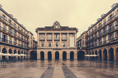
The Parte Vieja represents much more than a picturesque historic district—it’s where San Sebastián’s gastronomic heritage reaches its highest expression through the pintxo culture. Understanding this area requires recognizing how food in Basque culture transcends mere sustenance to become a sophisticated art form and social ritual.
The narrow streets follow a grid pattern established after the 1813 fire when Anglo-Portuguese forces fighting Napoleon burned the original medieval city. This destruction became an opportunity for planned rebuilding, resulting in the organized layout we see today. The street names offer historical insights—Calle 31 de Agosto (August 31st Street) commemorates the last street standing after the devastating fire.
The true magic of the Parte Vieja emerges in the evening during the txikiteo (pintxo crawl). This social custom involves moving from bar to bar, sampling one or two specialties at each establishment along with a small glass of wine or cider before moving on. This practice reflects the Basque emphasis on communal experiences and quality over quantity. Each pintxo bar specializes in certain creations, and locals know precisely which establishments excel at specific dishes.
The Plaza de la Constitución at the heart of the Old Town reveals its past as a bullring through the numbered balconies surrounding it. These numbers once designated viewing boxes for bullfights. Today, this square hosts important civic celebrations, including the drumming ceremony that marks the start of the city’s main festival, Semana Grande.
Location and Overview
Address: Parte Vieja, 20003 San Sebastián (Donostia), Gipuzkoa, Spain
Transportation Options
- Bus Services
- Multiple city bus lines serve the Old Town area
- Lines 5, 6, and 9 have stops near key locations
- Frequent service connecting different parts of the city
- Key Bus Stops:
- Plaza de la Constitución
- San Vicente Church
- Old Town main square
- Multiple city bus lines serve the Old Town area
- Train Connections
- Nearest Train Stations:
- Amara RENFE Station: 1.5 km from Old Town
- Donostia-San Sebastian Station: 2 km away
- Easy connections via local buses or short taxi ride
- Nearest Train Stations:
- Tram
- Euskotren (Local Tram System)
- Stops near the city center
- Convenient for tourists exploring multiple attractions
- Connects Old Town with other city districts
- Euskotren (Local Tram System)
Driving and Parking
Parking Options:
- Underground Parking Facilities
- Parking Boulevard
- Address: Calle Urdaneta, 5, 20006 San Sebastián
- Close proximity to Old Town
- Hourly and daily rates available
- Parking Easo
- Address: Calle Easo, 20, 20006 San Sebastián
- Convenient location
- Secure parking with reasonable rates
- Parking Boulevard
Visitor Information
Operating Hours
- Neighborhood Accessibility: Open 24/7
- Typical Business Hours:
- Shops: 10:00 AM – 8:00 PM (varies by establishment)
- Restaurants and Pintxos Bars: 12:00 PM – 11:00 PM
- Museums: Usually 10:00 AM – 6:00 PM
Key Attractions
- Plaza de la Constitución
- Historical main square
- Center of social and cultural activities
- Santa Maria del Coro Church
- Baroque-style architectural marvel
- Historical significance
- San Vicente Church
- Ancient parish church
- Architectural landmark
Contact Information
- San Sebastian Tourism Office
- Phone: +34 943 48 11 66
- Website: www.sansebastianturismo.com
- Email: turismo@sansebastian.eus
- Old Town Cultural Management
- Local Municipality: Donostia-San Sebastian City Council
- Cultural Heritage Department: +34 943 48 10 00
Nearby Attractions
- La Concha Beach
- Monte Urgull
- San Telmo Museum
- Zurriola Beach
-
Monte Igueldo

Monte Igueldo provides more than scenic views—it offers historical context for understanding San Sebastián’s development. This mountain has served as a strategic lookout point since the 16th century when a watchtower was built to spot approaching ships.
The funicular railway accessing the summit, opened in 1912, represents an early tourism infrastructure development. Its wooden cars have remained largely unchanged since their inception, preserving an authentic Belle Époque experience. The decision to build this railway coincided with San Sebastián’s growing prominence as a resort destination, making previously inaccessible viewpoints available to visitors.
The small amusement park at the summit dates from 1911 and maintains vintage attractions that create a nostalgic atmosphere. The wooden roller coaster, constructed in 1928, offers not just excitement but panoramic sea views during the ride—an unusual combination of thrills and scenic appreciation.
From Igueldo’s summit, you can comprehend how San Sebastián’s geography constrained and directed its development. The city expanded in a specific pattern dictated by its three hills and the Urumea River, creating distinct neighborhoods with different characters. This vantage point reveals San Sebastián’s adaptation to its natural setting rather than domination over it—a principle that reflects broader Basque values about human relationships with the environment.
Location and Overview
Address: Monte Igueldo, 20008 San Sebastián (Donostia), Gipuzkoa, Spain
Transportation Options
- Funicular Railway
- Monte Igueldo Funicular
- Starting Point: Base of Monte Igueldo
- Most unique and recommended way to reach the summit
- Historic funicular operating since 1912
- Scenic ride offering spectacular views during ascent
- Monte Igueldo Funicular
- Bus Services
- Local Bus Routes
- Line E21: Connects city center to Monte Igueldo
- Nearest bus stops:
- Igueldo Auzoa
- Funicular Station
- Operated by Dbus (San Sebastian Municipal Transport)
- Local Bus Routes
- Train and Tram Connections
- Nearest Train Stations:
- Amara RENFE Station: 4 km from Monte Igueldo
- Donostia-San Sebastian Station: 5 km away
- Connections available via local buses or taxi services
- Nearest Train Stations:
Driving and Parking
Parking Options:
- Dedicated Parking Areas
- Monte Igueldo Parking Lot
- Located near the Funicular Station
- Capacity for approximately 50-60 vehicles
- Charges apply during peak tourist seasons
- Monte Igueldo Parking Lot
Visitor Information
Operating Hours
- Funicular Railway
- Summer Season (June-September)
- Operating Hours: 10:30 AM – 8:00 PM
- Frequent departures every 15-20 minutes
- Winter Season (October-May)
- Operating Hours: 11:00 AM – 6:00 PM
- Less frequent departures
- Summer Season (June-September)
- Amusement Park and Viewpoint
- Open daily during tourist season
- Some attractions may have seasonal variations
Ticket Information
- Funicular Railway
- Round Trip Ticket: €3.50 (Adults)
- One-Way Ticket: €2.50
- Children and Senior Discounts Available
- Amusement Park
- Separate ticket required
- Various package deals available
Contact Information
- Monte Igueldo Funicular
- Phone: +34 943 21 23 26
- Website: www.monteigueldo.eus
- San Sebastian Tourism Office
- Phone: +34 943 48 11 66
- Email: turismo@sansebastian.eus
Nearby Attractions
- La Concha Beach
- Parte Vieja (Old Town)
- Miramar Palace
- San Telmo Museum
-
San Telmo Museum
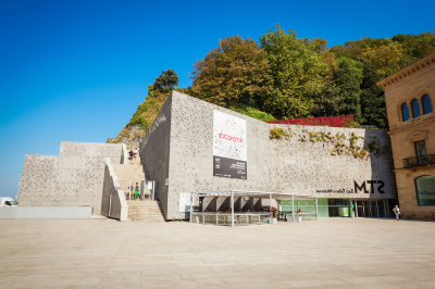
The San Telmo Museum functions as a critical lens for interpreting everything else you’ll experience in San Sebastián. Without understanding Basque cultural identity—central to this museum’s mission—many aspects of the city remain merely picturesque rather than meaningful.
Housed in a 16th-century Dominican monastery with a modern extension, the building itself tells a story of preservation and innovation. The juxtaposition of the historic structure with contemporary architecture by Nieto Sobejano mirrors the Basque ability to maintain traditional identity while embracing modernity.
The museum’s permanent collection documents the evolution of Basque society through archaeological finds, ethnographic displays, and art. Particularly significant are the José María Sert murals in the former church space, which depict pivotal moments in Basque history. Completed between 1929 and 1936, these works were commissioned specifically for this space, transforming a religious building into a secular temple of cultural identity.
What makes this museum exceptional is how it contextualizes the Basque experience. You’ll learn about traditional rural lifestyles centered around the baserri (farmhouse) system, understand the importance of the sea in Basque economy and identity, and discover how industrialization transformed the region in the late 19th and early 20th centuries. This knowledge enhances everything else you’ll experience in San Sebastián—from the food you eat to the language you hear spoken.
Location and Overview
Address: Plaza Zuloaga, 1, 20003 San Sebastián (Donostia), Gipuzkoa, Spain
Transportation Options
- Bus Services
- Local Bus Lines:
- Line 5: Direct route to Old Town
- Line 6: Connects major city areas
- Line 9: Serves tourist locations
- Nearest Bus Stops:
- Plaza Zuloaga
- Old Town (Parte Vieja) stops
- Local Bus Lines:
- Train Connections
- Nearest Train Stations:
- Amara RENFE Station: 1.5 km from museum
- Donostia-San Sebastian Station: 2 km away
- Easy transfer via local buses or short taxi ride
- Nearest Train Stations:
- Tram
- Euskotren (Local Tram System)
- Stops near city center
- Short walking distance to museum
- Euskotren (Local Tram System)
Driving and Parking
Parking Options:
- Nearby Parking Facilities
- Parking Boulevard
- Address: Calle Urdaneta, 5, 20006 San Sebastián
- Closest major parking garage
- Hourly and daily rates available
- Parking Easo
- Address: Calle Easo, 20, 20006 San Sebastián
- Additional parking option
- Secure and monitored
- Parking Boulevard
Visitor Information
Museum Operating Hours
- Regular Hours:
- Tuesday-Sunday: 10:00 AM – 8:00 PM
- Closed on Mondays (except public holidays)
Ticket Information
- Admission Prices:
- Adults: €6
- Reduced Rate (Students, Seniors): €3
- Children under 12: Free
- Free entry on specific days (typically first Sunday of each month)
Contact Information
- Museum Administration
- Phone: +34 943 48 16 50
- Email: museoa@donostia.eus
- Website: www.santelmomuseoa.eus
- San Sebastian Tourism Office
- Phone: +34 943 48 11 66
- Email: turismo@sansebastian.eus
Nearby Attractions
- Parte Vieja (Old Town)
- La Concha Beach
- Monte Urgull
- Plaza de la Constitución
-
Kursaal Congress Centre and Auditorium
The Kursaal represents San Sebastián’s contemporary identity and ambitions. Designed by Rafael Moneo and completed in 1999, this striking building consists of two translucent cubes that appear to be emerging from the coastline at the mouth of the Urumea River.
The structure replaced an earlier entertainment complex (the original “Kursaal”) that served as a casino until gambling was prohibited in Spain in 1924. The name “Kursaal” comes from German, meaning “cure hall” or “spa hall,” referencing its original purpose in European spa towns as a social and recreational center for visitors. This linguistic vestige hints at San Sebastián’s historical connection to European tourism traditions.
What makes the Kursaal architecturally significant is how it responds to its specific location. Moneo designed the building to reference two large rocks that once stood at the river mouth. The translucent cubes are tilted at slightly different angles, creating a dynamic relationship that changes depending on the viewer’s position. The building’s exterior skin consists of translucent glass panels that transform dramatically from day to night—appearing solid and crystalline during daylight but glowing from within after dark, creating a lighthouse effect.
The Kursaal houses the San Sebastián International Film Festival, one of Europe’s most prestigious cinema events. This cultural function reflects the city’s evolution from a seasonal resort to a year-round cultural destination with international significance. The open public space created between the building and the sea has become an important gathering point, demonstrating how contemporary architecture can enhance urban life and public interaction.
Location
Address: Av. de Zurriola, 1, 20002 San Sebastián (Donostia), Gipuzkoa, Spain
Transportation Options
- Bus Services
- Local Bus Lines:
- Line 5: Connects Old Town and city center
- Line 9: Serves tourist and cultural locations
- Line E21: Runs along the coastal area
- Nearest Bus Stops:
- Zurriola Bridge
- Kursaal Stop
- Miraconcha Avenue
- Local Bus Lines:
- Train Connections
- Nearest Train Stations:
- Amara RENFE Station: 1.8 km from Kursaal
- Donostia-San Sebastian Station: 2.2 km away
- Easy transfer via local buses or short taxi ride
- Nearest Train Stations:
- Tram
- Euskotren (Local Tram System)
- Stops near city center
- Short walking distance to Kursaal
- Euskotren (Local Tram System)
Driving and Parking
Parking Options:
- Dedicated Parking Facilities
- Underground Parking at Kursaal
- Directly beneath the complex
- Capacity for approximately 600 vehicles
- Rates: Hourly and daily parking available
- Nearby Parking Garages:
- Parking Boulevard
- Parking Easo
- Secure, monitored parking with reasonable rates
- Underground Parking at Kursaal
Visitor Information
Operating Hours
- General Building Access:
- Monday-Friday: 9:00 AM – 9:00 PM
- Weekend hours vary based on events
- Event-Specific Hours:
- Depend on scheduled concerts, conferences, and performances
- Check official website or ticket information for specific timings
Ticket and Event Information
- Ticket Purchase:
- Online booking: www.kursaal.eus
- Box Office: Located in the main building
- Phone bookings available
- Pricing:
- Varies by event
- Discounts for students, seniors, and groups
- Some events offer free entry
Contact Information
- Kursaal Administration
- Phone: +34 943 00 43 00
- Email: info@kursaal.eus
- Website: www.kursaal.eus
Nearby Attractions
- Zurriola Beach
- Parte Vieja (Old Town)
- Monte Urgull
- San Telmo Museum
Bilbao

Bilbao represents one of Spain’s most remarkable urban transformations, evolving from an industrial port city to a cultural and architectural destination. Understanding Bilbao requires appreciating how this metamorphosis occurred and what makes each of its key sites significant beyond their surface appeal. Let me guide you through the five most essential places that reveal Bilbao’s identity.
For more details visit: https://www.bilbaoturismo.net/BilbaoTurismo/en/tourists
-
Guggenheim Museum Bilbao
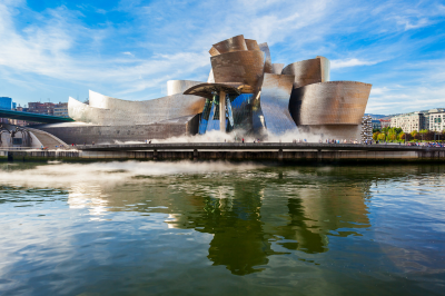
The Guggenheim Museum Bilbao stands as the primary catalyst for what urban planners now call the “Bilbao Effect”—when a single architectural project transforms an entire city’s economy and reputation. Completed in 1997 and designed by Frank Gehry, this titanium-clad structure revolutionized not just Bilbao but our global understanding of how architecture can revitalize cities.
To truly understand the Guggenheim’s significance, we need to consider its context. It was built on former industrial land along the Nervión River as part of a comprehensive urban renewal plan following the collapse of Bilbao’s traditional manufacturing and shipbuilding industries in the 1980s. The city made a bold decision to invest in culture and design rather than attempting to resurrect its industrial past.
The building’s design responds directly to Bilbao’s specific geography and industrial heritage. The titanium exterior panels reference the city’s shipbuilding history, while the curvaceous forms echo the surrounding hills and the meandering river. These seemingly random curves are actually precisely calculated using advanced computer modeling that was groundbreaking at the time of construction.
When you approach the museum, you’ll notice how it changes appearance depending on the weather and time of day. The titanium panels reflect light differently under various conditions—sometimes appearing golden, sometimes silver, and occasionally taking on a bluish hue. This changeability mirrors Bilbao’s own transformation from industrial workhorse to dynamic cultural center.
Inside, the museum’s soaring atrium demonstrates how architecture can create emotional experiences through space and light. The galleries were designed specifically to house monumental contemporary artworks that wouldn’t fit in conventional museums. When examining the permanent collection, pay special attention to works by Basque artists which provide insight into the region’s distinctive cultural identity.
Location and Address
Address: Abandoibarra Etorbidea, 2, 48009 Bilbo, Bizkaia, Spain
Transportation Options
- Metro
- Nearest Metro Stations:
- Moyua Station (Line 1): Approximately 10-minute walk
- Abandoibarra Station (Line 1): Closest station, just 5 minutes from the museum
- Nearest Metro Stations:
- Bus
- Bilbobus Routes serving the museum:
- Routes 01, 06, 09, and 11 stop near the museum
- Bus stops located on Abandoibarra Avenue and nearby streets
- Bilbobus Routes serving the museum:
- Tram
- Nearby Tram Stops:
- Guggenheim Stop: Directly in front of the museum
- Moyua Stop: Close to the museum, convenient alternative
- Nearby Tram Stops:
Driving and Parking
- Parking Options
- Guggenheim Museum Parking
- Underground parking directly at the museum
- Capacity: Approximately 350 vehicles
- Rates: Typically €4-6 per hour (confirm current pricing)
- Nearby Public Parking Locations
- Parking Abandoibarra
- Plaza Euskadi Parking
- ZABALBIDE Parking
- Guggenheim Museum Parking
- Driving Directions
- Located in the Abandoibarra area of Bilbao
- Easily accessible from the BI-631 and BI-637 highways
Museum Details
Opening Hours
- Summer Season (June-September)
- Tuesday-Sunday: 10:00 AM – 8:00 PM
- Closed: Mondays (except holidays)
- Winter Season (October-May)
- Tuesday-Sunday: 10:00 AM – 7:00 PM
- Closed: Mondays (except holidays)
Contact Information
- Phone: +34 944 35 90 80
- Email: info@guggenheim-bilbao.eus
- Website: www.guggenheim-bilbao.eus
Ticket Information
- Ticket Prices (as of 2024, subject to change)
- Adults: €16
- Reduced Rate (students, seniors): €10
- Children under 12: Free
- Online booking recommended to avoid queues
Nearby Attractions
- Bilbao Fine Arts Museum
- Arriaga Theatre
- Mercado de la Ribera (River Market)
- Doña Casilda Iturrizar Park
-
Casco Viejo (Old Town)

Bilbao’s Casco Viejo offers a profound contrast to the ultramodern Guggenheim, demonstrating the city’s ability to preserve its heritage while embracing innovation. This medieval quarter, known locally as “Las Siete Calles” (The Seven Streets), constitutes Bilbao’s original urban core, founded in 1300.
To truly appreciate the Casco Viejo, consider that these narrow streets survived devastating floods in 1983 that submerged the district under more than five meters of water. The subsequent restoration reflects Bilbao’s resilience and commitment to preserving its historical identity even while pursuing modernization elsewhere in the city.
The Plaza Nueva, a neoclassical square completed in 1851, serves as the social heart of the Old Town. The square’s uniform facades with elegant arcades demonstrate 19th-century urban planning principles that sought to create harmonious public spaces. On Sundays, a market fills this plaza, continuing a tradition that dates back to the square’s original purpose as a commercial center.
The Ribera Market at the edge of the Casco Viejo merits special attention. Recently renovated, this riverfront market represents the largest covered market in Europe. Beyond merely selling food, it functions as a cultural institution where traditional Basque culinary practices are preserved and celebrated. The market’s prominent location along the river reflects Bilbao’s historical connection to both maritime trade and the agricultural bounty of the surrounding countryside.
As you explore the narrow streets, notice how traditional bars serving pintxos (Basque tapas) coexist with contemporary boutiques, illustrating Bilbao’s talent for integrating past and present. Many of these establishments have been family-owned for generations, preserving recipes and techniques that form an essential part of Basque cultural heritage.
Location and Overview
Area: Historic District of Bilbao
Boundaries: Bounded by the Nervión River and Plaza Circular
Transportation Options
- Metro
- Nearest Metro Stations:
- Casco Viejo Station (Line 1): Directly in the heart of the old town
- Arriaga Station: Adjacent to the old town area
- Moyua Station: Close connection to the old town
- Nearest Metro Stations:
- Bus
- Bilbobus Routes serving Casco Viejo:
- Routes 01, 06, 09, and 11 stop near or within the old town
- Multiple bus stops throughout the area
- Bilbobus Routes serving Casco Viejo:
- Tram
- Nearby Tram Stops:
- Arriaga Stop: Right at the edge of Casco Viejo
- Plaza Circular Stop: Convenient access point
- Nearby Tram Stops:
Driving and Parking
- Parking Options
- Public Parking Locations
- Parking Plaza Nueva
- Parking Santiago
- Parking Askao
- Underground parking near Plaza Moyua
- Public Parking Locations
- Driving Considerations
- Narrow, historic streets
- Many areas are pedestrian-only
- Best explored on foot
Nearby Attractions
- Guggenheim Museum
- Bilbao Fine Arts Museum
- Doña Casilda Iturrizar Park
- Ribera Market
Tourist Information
- Bilbao Tourist Office
- Location: Plaza Circular, 4
- Phone: +34 944 79 57 86
- Website: www.bilbaoturismo.net
- Services: Maps, guides, local information
-
Azkuna Zentroa (Alhóndiga Bilbao)

The Azkuna Zentroa exemplifies Bilbao’s approach to adaptive reuse—transforming industrial heritage rather than erasing it. Originally built in 1909 as a wine warehouse, this massive structure sat abandoned for years before being reimagined by designer Philippe Starck and reopened in 2010 as a multidisciplinary cultural center.
What makes this building extraordinary is the contrast between its preserved historical exterior and its dramatically transformed interior. When you enter, you’ll encounter 43 distinctive columns supporting the structure—each uniquely designed by Starck in different materials and styles ranging from brick to marble, from bronze to wood, from classical to whimsical. These columns serve as a metaphorical United Nations of world cultures, suggesting Bilbao’s openness to global influences while maintaining its own identity.
The complex includes a public library, cinema, fitness center, restaurants, exhibition spaces, and an elevated glass-bottomed swimming pool that creates an unusual spatial experience for both swimmers and visitors below. This multifunctional approach reflects contemporary ideas about public space as places where cultural consumption, creation, leisure, and learning can coexist.
The rooftop terrace offers an important perspective on Bilbao’s urban landscape, revealing how the city sits in a valley surrounded by green mountains—a geographical context that often surprises visitors who arrive expecting only urban environments. This view helps explain why Bilbao’s residents maintain such strong connections to the natural environment despite living in a major city.
Location and Overview
Address: Plaza Arriquibar, 4, 48010 Bilbao, Bizkaia, Spain
Designed by: Philippe Starck
Transportation Options
- Metro
- Nearest Metro Stations:
- Moyua Station (Line 1): Directly adjacent to Azkuna Zentroa
- Abando Station: Short walking distance (10 minutes)
- Nearest Metro Stations:
- Bus
- Bilbobus Routes:
- Routes serving nearby areas:
- Routes 01, 06, 08, 09, 11
- Stops on Plaza Moyua and surrounding streets
- Routes serving nearby areas:
- Bilbobus Routes:
- Tram
- Nearby Tram Stops:
- Moyua Stop: Immediate proximity to the center
- Plaza Circular Stop: Alternative access point
- Nearby Tram Stops:
Driving and Parking
- Parking Options
- Nearby Public Parking Locations
- Parking Plaza Moyua
- Parking Indautxu
- Underground parking at Plaza Arriquibar
- Plaza Euskadi Parking
- Parking Tips
- Limited street parking
- Recommended to use nearby public parking facilities
- Parking rates typically range from €2-4 per hour
- Nearby Public Parking Locations
Visitor Information
Opening Hours
- General Hours
- Monday-Sunday: 10:00 AM – 9:00 PM
- Closed: Some holidays (check official website)
- Library Hours
- Monday-Friday: 9:00 AM – 8:30 PM
- Saturday: 10:00 AM – 2:00 PM
- Sunday: Closed
Contact Information
-
- Phone: +34 944 01 40 00
- Email: info@azkunazentroa.eus
Ticket and Entry Information
- Admission
- Most areas free to enter
- Specific exhibitions or events may have separate ticket prices
- Cultural activities often require prior registration
Nearby Attractions
- Moyua Square
- Gran Vía de Don Diego López de Haro
- Bilbao Fine Arts Museum
- Dona Casilda Park
Special Programs
- Cultural workshops
- Movie screenings
- Fitness classes
- Art exhibitions
- Educational programs
-
Abandoibarra Riverfront Promenade
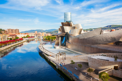
Bilbao’s relationship with the Nervión River has fundamentally changed over the past three decades, and nowhere is this transformation more evident than along the Abandoibarra riverfront. Once lined with shipyards and industrial facilities that physically and psychologically separated citizens from the water, this area has been reclaimed as public space through thoughtful urban planning.
When walking this promenade, consider that you’re traversing what was once inaccessible industrial land. The creation of this pedestrian-friendly riverfront was part of a comprehensive plan that included cleaning the heavily polluted river—a process that has been so successful that fish have returned to waters that were once biologically dead.
The pathway connects several architectural landmarks beyond the Guggenheim, including the Zubizuri Bridge designed by Santiago Calatrava. This white pedestrian bridge, whose name means “white bridge” in Basque, features a glass walkway and curving structural elements that have become another symbol of the new Bilbao. The bridge demonstrates how even functional infrastructure can become artistic expression and tourist attraction.
As you stroll along the river, notice how public art has been integrated throughout the area. “Puppy,” Jeff Koons’ monumental floral sculpture outside the Guggenheim, and “Maman,” Louise Bourgeois’ giant spider sculpture, have become beloved landmarks that residents identify with just as much as visitors. This integration of contemporary art into public space reflects Bilbao’s commitment to making cultural experiences accessible rather than exclusive.
The riverfront also reveals Bilbao’s commitment to sustainable transportation through its efficient tram system that runs parallel to portions of the promenade, reducing car dependency while connecting key city destinations. This emphasis on pedestrian spaces and public transit represents a fundamental shift from the industrial city’s previous prioritization of functional infrastructure over human-centered design. I’ll create a comprehensive guide to visiting the Abandoibarra Riverfront Promenade in Bilbao.
Location and Overview
Area: Modern urban waterfront district
Length: Approximately 2.5 kilometers
Location: Along the Nervión River in central Bilbao
Transportation Options
- Metro
- Nearest Metro Stations:
- Abandoibarra Station (Line 1): Directly on the promenade
- Guggenheim Station: Adjacent to the promenade
- Moyua Station: Close walking distance
- Nearest Metro Stations:
- Bus
- Bilbobus Routes:
- Routes serving Abandoibarra:
- Routes 01, 06, 09, 11
- Multiple stops along the riverfront
- Convenient access from city center
- Routes serving Abandoibarra:
- Bilbobus Routes:
- Tram
- Nearby Tram Stops:
- Guggenheim Stop
- Abandoibarra Stop
- Direct access to the promenade
- Nearby Tram Stops:
Driving and Parking
- Parking Options
- Nearby Parking Facilities
- Guggenheim Museum Parking
- Abandoibarra Parking
- Plaza Euskadi Underground Parking
- Multiple street and underground parking options
- Parking Tips
- Ample parking near major attractions
- Rates typically €2-4 per hour
- Parking meters and underground garages available
- Nearby Parking Facilities
- Driving Directions
- Easily accessible from city center
- Close to major highways BI-631 and BI-637
Nearby Attractions
- Guggenheim Museum
- Iberdrola Tower
- Doña Casilda Iturrizar Park
- San Mamés Stadium
- Bilbao Fine Arts Museum
-
Artxanda Funicular and Viewpoint

To fully comprehend Bilbao, one must see it from above, and the Artxanda Funicular provides this essential perspective. Operating since 1915, this historic cable railway carries passengers to a viewing platform that reveals the city’s unique topography—a relatively narrow valley with development concentrated along the river and climbing partway up the surrounding hills.
The three-minute journey itself represents an important piece of Bilbao’s transportation history. The funicular was built to give city residents easy access to cleaner air and recreation areas above the once-polluted industrial valley. Today, it continues to serve both practical and touristic purposes, demonstrating how historical infrastructure can remain relevant through changing urban contexts.
From the viewpoint, you can observe how Bilbao’s development has been constrained and shaped by its geography. The linear arrangement of the city following the river’s path becomes apparent, as does the greenbelt that surrounds the urban area—an important factor in maintaining quality of life despite industrial history.
This panorama also reveals the distinct neighborhoods that comprise Bilbao, from the medieval Casco Viejo to the 19th-century Ensanche (expansion district) with its grid pattern, to newer developments along the river. The view illustrates how Bilbao’s various urban planning approaches across different historical periods have created a layered city rather than one with a single dominant character.
During clear days, you can also glimpse the sea in the distance, reminding you of Bilbao’s historical connection to maritime trade that fueled its initial industrial growth. This visual connection to the Bay of Biscay helps explain the city’s historical and ongoing relationship with global commerce and influences.
The Artxanda viewpoint area itself features restaurants serving traditional Basque cuisine, creating an opportunity to connect the visual understanding of the city with its culinary culture. The outdoor recreation areas nearby demonstrate the Basque appreciation for maintaining connections to natural environments even when developing urban spaces.
Location and Overview
Address: Funicular de Artxanda, Calle Esperanza, 4, 48007 Bilbao, Bizkaia, Spain
Elevation: Rises approximately 250 meters above Bilbao
Transportation Options
Funicular Transportation
- Funicular Details
- Starting Point: Base station in Santutxu neighborhood
- Destination: Artxanda Viewpoint
- Travel Time: Approximately 3-4 minutes
- Frequency: Every 15-20 minutes
How to Reach the Funicular Base Station
- Public Transportation
- Metro
- Santutxu Station (Line 1): Directly adjacent to funicular base station
- Urbinaga Station: Alternative access point
- Bus
- Bilbobus Routes:
- Routes 01, 06, 09 stop near the funicular
- Specific stops: Santutxu and Esperanza Street
- Bilbobus Routes:
- Metro
- Driving and Parking
- Parking Options
- Street parking near base station
- Nearby public parking lots
- Limited parking at funicular base
- Recommended to use public transportation
- Parking Options
Detailed Visitor Information
Funicular and Viewpoint Details
- Operating Hours
- Summer (April-September)
- Monday-Sunday: 10:00 AM – 9:00 PM
- Winter (October-March)
- Monday-Sunday: 10:00 AM – 7:00 PM
- Summer (April-September)
- Ticket Information
- Single Journey
- Adults: €3.50
- Children (4-12 years): €1.75
- Seniors (65+): €1.75
- Children under 4: Free
- Round Trip
- Adults: €5.50
- Reduced rates available
- Single Journey
Nearby Attractions
- Natural Attractions
- Artxanda Park
- Hiking trails
- Picnic areas
- Mountain bike routes
- Cultural Sites
- Mount Artxanda Botanical Gardens
- Local historical markers
- Traditional Basque farmhouses
Contact Information
- Funicular Office
- Phone: +34 944 23 35 59
- Website: www.bilbaoturismo.net
- Email: funicular@bilbao.eus
Toledo

Toledo is often called the “City of Three Cultures” because Christians, Muslims, and Jews coexisted here for centuries, each leaving their distinctive mark on the city’s architecture, cuisine, and traditions. This layered cultural heritage makes Toledo not just beautiful but historically significant in ways that aren’t immediately obvious to visitors. Let me guide you through the five most essential places to understand Toledo’s unique identity.
For more details visit: https://visittoledo.org/
-
Toledo Cathedral (Catedral Primada Santa María de Toledo)
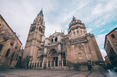
Toledo Cathedral isn’t just another European church—it represents the pinnacle of Spanish Gothic architecture and serves as a three-dimensional textbook of Spain’s religious and artistic evolution.
Construction began in 1226 but continued for 267 years, resulting in a building that incorporates multiple architectural styles. While primarily Gothic, you’ll notice Mudéjar elements (influenced by Islamic design) in the triforium gallery and Renaissance features in later chapels. This stylistic mixing reflects Toledo’s multicultural character.
What makes this cathedral particularly significant is its status as Spain’s religious center—the seat of the Primate of Spain—which gave Toledo enormous ecclesiastical power throughout history. When you enter the cathedral, you’re walking into what was once one of the most influential religious institutions in the Christian world.
The cathedral’s interior contains several treasures of remarkable significance. The transparent, an elaborate Baroque altarpiece with an opening that allows natural light to illuminate it, represents a technical and artistic marvel that solved the problem of bringing light into a specific part of the otherwise dark cathedral. This innovative solution exemplifies how architectural problems were approached with both technical ingenuity and artistic sensibility.
The sacristy functions as a mini-museum housing masterpieces by El Greco, Goya, and Velázquez. When viewing El Greco’s works, remember that he lived in Toledo, and the elongated figures and dramatic lighting of his paintings were influenced by the city’s unique quality of light and the spiritual atmosphere of Counter-Reformation Toledo.
Location and Overview
Address: Plaza del Ayuntamiento, s/n, 45002 Toledo, Spain
Transportation Options
- Train
- Nearest Train Stations:
- Toledo Station (RENFE)
- Direct connections from Madrid (30-minute high-speed train)
- Regular regional train services
- Nearest Train Stations:
- Bus
- Bus Stations:
- Toledo Bus Station
- Multiple regional and national bus routes
- Connections from Madrid and nearby cities
- Bus Stations:
- Metro and Local Transport
- Limited local public transport in Toledo
- Recommended: Walking or taxi within the city
- Frequent bus connections within city center
Driving and Parking
- Parking Options
- Nearby Parking Facilities:
- Parking Plaza de Zocodover
- Underground parking near City Hall
- Street parking with time limitations
- Public parking areas around historic center
- Nearby Parking Facilities:
Visitor Information
Opening Hours
- Summer Season (April-September)
- Monday-Saturday: 10:00 AM – 6:30 PM
- Sunday: 2:00 PM – 6:30 PM
- Winter Season (October-March)
- Monday-Saturday: 10:00 AM – 5:30 PM
- Sunday: 2:00 PM – 5:30 PM
- Closed:
- Some religious holidays
- During special events
- Check official website for current schedule
Ticket Information
- Admission Prices
- General Admission: €10
- Reduced Rate (students, seniors): €8
- Children under 12: Free
- Guided Tour: Additional €5
- Audio Guide: €3
Cathedral Highlights
- Must-See Areas
- Main Altar
- Choir Stalls
- Chapel of the New Monarchs
- Treasury
- Chapter House
- Sacristy
Nearby Attractions
- Historical Sites
- Alcázar of Toledo
- Synagogue of Santa María la Blanca
- Monastery of San Juan de los Reyes
- Toledo City Hall
- Museums
- El Greco Museum
- Santa Cruz Museum
- Toledo Museum of History
Contact Information
- Cathedral Administration
-
- Phone: +34 925 22 21 22
- Email: info@catedraldetoledo.org
-
-
Monastery of San Juan de los Reyes
This monastery exemplifies how architecture was used as political propaganda in medieval Spain. Commissioned by Queen Isabella I of Castile to commemorate her victory at the Battle of Toro and the birth of her son, the building was originally intended as a royal mausoleum (though the Catholic Monarchs were ultimately buried in Granada after its reconquest).
What makes San Juan de los Reyes particularly interesting is its exterior decoration. Chains hanging from the outer walls are not merely decorative—they once bound Christian prisoners freed from Muslim territories during the Reconquista. These chains served as a powerful visual reminder of the monarchy’s role as defenders of Christianity and liberators of the faithful.
The building’s architectural style is Isabelline Gothic, named after the queen herself, which combines late Gothic elements with Mudéjar influences and emerging Renaissance features. This hybrid style perfectly represents the transitional period in which it was built, as Spain moved from medieval kingdom to world empire.
The two-level cloister provides an excellent example of how architectural spaces regulated monastic life. The lower level, with its garden representing paradise, was designed for meditation and contemplation, while the upper level provided protection from Toledo’s extreme weather. The detailed stone carvings throughout feature the emblems of the Catholic Monarchs (the eagle of Saint John, the yoke, and the bundle of arrows), demonstrating how thoroughly religious and political power were intertwined.
Location and Overview
Address: Calle de los Reyes Católicos, s/n, 45002 Toledo, Spain
Detailed Visitor Information
Opening Hours
- Summer Season (April-September)
- Tuesday-Sunday: 10:00 AM – 6:30 PM
- Monday: Closed
- Winter Season (October-March)
- Tuesday-Sunday: 10:00 AM – 5:30 PM
- Monday: Closed
- Holidays and Special Events
- Hours may vary
- Check official website for current schedule
Ticket Information
- Admission Prices
- General Admission: €4.50
- Reduced Rate (students, seniors): €3.50
- Children under 12: Free
- Guided Tour: Additional €2
- Audio Guide: €2
Monastery Highlights
- Must-See Areas
-
- Main Church
- Royal Cloister
- Chapter House
- Courtyard
- Historical Exhibition Rooms
Historical Significance
- Commissioned by Catholic Monarchs Isabel and Fernando
- Commemorates Christian victory in Granada
- Originally intended as royal pantheon
- Symbolizes medieval Spanish royal power
Nearby Attractions
- Historical Sites
- Catedral Primada Santa María
- Alcázar of Toledo
- Synagogue of Santa María la Blanca
- Toledo City Hall
- Museums
- El Greco Museum
- Santa Cruz Museum
- Toledo Museum of History
Contact Information
- Monastery Administration
-
- Phone: +34 925 22 21 22
- Email: info@monasteriodesanjuan.com
-
-
Sinagoga del Tránsito and Sephardic Museum
The Synagogue of El Tránsito offers crucial insights into medieval Jewish culture and the complex religious dynamics of pre-1492 Spain. Built in 1356 by Samuel ha-Levi, treasurer to King Pedro I of Castile, this synagogue is remarkable because its construction required special royal permission at a time when new synagogues were generally prohibited.
The building’s architecture tells a story of cultural exchange and coexistence. The prayer hall combines Mudéjar craftsmanship (created by Muslim artisans) with Jewish religious requirements and symbolism. The elaborate stucco decorations feature Arabic-style geometric patterns alongside Hebrew inscriptions and floral motifs. This visual synthesis demonstrates how the three cultures of Toledo—Christian, Muslim, and Jewish—influenced each other artistically even while maintaining distinct religious identities.
When examining the women’s gallery, consider how it reflects gender segregation in medieval Jewish worship while also providing women with a space within the religious community. The fact that women’s spaces in synagogues were often architectural afterthoughts helps explain why this gallery appears somewhat awkwardly integrated into the building’s overall design.
The attached Sephardic Museum documents Jewish life in Spain before the 1492 expulsion, preserving artifacts that would otherwise have been lost to history. Pay special attention to the traditional ketubah (marriage contracts) and the Hebrew manuscripts that showcase the intellectual contributions of Toledo’s Jewish community, which included scholars and translators who helped transmit classical Greek knowledge to medieval Europe via Arabic texts.
Understanding this synagogue and museum is essential for grasping Toledo’s claim to be a city of three cultures and for recognizing the contributions of Sephardic Jews to Spanish culture before their expulsion transformed both Spain and the wider Jewish diaspora.
Location and Overview
Address: Calle Samuel Levi, s/n, 45002 Toledo, Spain
Detailed Visitor Information
Opening Hours
- Summer Season (April-September)
- Tuesday-Saturday: 10:00 AM – 6:30 PM
- Sunday: 10:00 AM – 3:00 PM
- Monday: Closed
- Winter Season (October-March)
- Tuesday-Saturday: 10:00 AM – 5:30 PM
- Sunday: 10:00 AM – 3:00 PM
- Monday: Closed
Ticket Information
- Admission Prices
- General Admission: €3.50
- Reduced Rate (students, seniors): €2.50
- Children under 12: Free
- Combined ticket with other Toledo museums: €6
- Audio Guide: €2
Museum Highlights
- Architectural Features
- Mudéjar architectural style
- Intricate Hebrew inscriptions
- Ornate wall decorations
- Historical preserved synagogue interior
- Impressive ornamental details
- Museum Sections
- Synagogue main hall
- Sephardic Jewish history exhibition
- Artifacts and historical documents
- Multimedia presentations
- Cultural heritage displays
Nearby Attractions
- Historical Sites
- Catedral Primada Santa María
- Monastery of San Juan de los Reyes
- Alcázar of Toledo
- Santa María la Blanca Synagogue
- Museums
- El Greco Museum
- Santa Cruz Museum
- Toledo Museum of History
Contact Information
- Museum Administration
- Phone: +34 925 22 21 22
- Website: www.museosefardi.com
- Email: info@museosefardi.com
-
Alcázar of Toledo
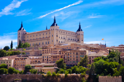
The Alcázar exemplifies how a single building can embody numerous historical transitions. Originally a Roman palace, then a Visigothic fortress, later an Islamic citadel, and eventually a Spanish royal residence, the structure you see today has been repeatedly destroyed and rebuilt, most recently after the Spanish Civil War.
The building’s strategic position on Toledo’s highest point explains why every power that controlled the city prioritized holding this fortress. From its location, you can understand why Toledo was considered one of the most defensible cities in Spain, with the Tagus River forming a natural moat around three sides of the city.
What makes the Alcázar particularly significant is its role in the Spanish Civil War. During the 1936 Siege of the Alcázar, Nationalist forces held out against Republican troops for 70 days despite being outnumbered, creating a powerful propaganda narrative that bolstered Franco’s cause. The bullet marks still visible on some exterior walls serve as visceral reminders of this relatively recent conflict.
Today, the building houses the Army Museum, which documents Spanish military history from the Middle Ages to the present. When exploring this museum, consider how its narrative presentation of Spanish military history reflects changing perspectives on Spain’s imperial past and the complicated legacy of the Civil War.
The Alcázar’s multiple reconstructions and repurposings mirror Spain’s own complex history—a continuous process of cultural layering rather than simple progression from one era to another. This palimpsest quality characterizes much of Toledo and helps explain why the city feels simultaneously ancient and alive.
Location and Overview
Address: Calle Unión, s/n, 45001 Toledo, Spain
Historical Significance: Iconic symbol of Toledo’s military and cultural history
Detailed Visitor Information
Opening Hours
- Summer Season (April-September)
- Tuesday-Saturday: 10:00 AM – 6:30 PM
- Sunday: 10:00 AM – 3:00 PM
- Monday: Closed
- Winter Season (October-March)
- Tuesday-Saturday: 10:00 AM – 5:30 PM
- Sunday: 10:00 AM – 3:00 PM
- Monday: Closed
- Holidays and Special Events
- Hours may vary
- Check official website for current schedule
Ticket Information
- Admission Prices (as of 2024)
- General Admission: €5
- Reduced Rate (students, seniors): €3.50
- Children under 12: Free
- Guided Tour: Additional €2
- Audio Guide: €2
Alcázar Highlights
- Architectural Features
- Imposing fortress design
- Multiple historical architectural layers
- Panoramic views of Toledo
- Significant military museum
- Restored historical interiors
- Museum Sections
- Military history exhibition
- Spanish Civil War memorial
- Historical artifacts
- Weaponry collections
- Multimedia presentations
Nearby Attractions
- Historical Sites
- Catedral Primada Santa María
- Monastery of San Juan de los Reyes
- Sinagoga del Tránsito
- Santa María la Blanca Synagogue
- Museums
- El Greco Museum
- Santa Cruz Museum
- Toledo Museum of History
Contact Information
- Alcázar Museum Administration
- Phone: +34 925 23 93 40
- Email: museoejercito@mde.es
-
Mirador del Valle (Valley Viewpoint)

While technically not a building or museum, this panoramic viewpoint provides the most comprehensive understanding of Toledo’s urban development and geographical context. Located across the Tagus River, this vantage point reveals why Toledo was considered nearly impregnable throughout much of its history.
From this perspective, several key features become apparent. First, you’ll notice how the city occupies a rocky promontory almost entirely encircled by the Tagus River, creating a natural defensive position that determined Toledo’s historical importance as a fortress city. Second, the compact nature of development within the old city walls demonstrates how limited space shaped urban planning, resulting in the narrow, winding streets that characterize historic Toledo.
The view also reveals the city’s architectural hierarchy. The Cathedral and Alcázar dominate the skyline, their prominence reflecting the dual powers of church and state that governed medieval life. The distributed pattern of church towers throughout the cityscape indicates how parishes organized social life in pre-modern Spain.
Visiting at different times of day transforms the experience—morning light highlights the eastern facades, while sunset bathes the city in golden light that explains why El Greco painted Toledo with such dramatic illumination. This changing quality of light has inspired artists for centuries and helps explain Toledo’s enduring appeal to painters and photographers.
Understanding Toledo from this external perspective helps make sense of the labyrinthine interior experience. When you later navigate the narrow streets, you’ll appreciate how the city’s unusual topography necessitated its distinctive urban form.
Balearic Islands
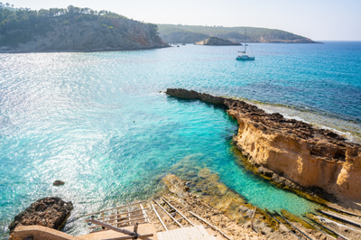
The Balearic Islands form an enchanting archipelago located in the western Mediterranean Sea, belonging to Spain. This island group consists of four main inhabited islands—Mallorca (Majorca), Menorca (Minorca), Ibiza, and Formentera—along with numerous smaller islets, creating a diverse and captivating region with a rich historical tapestry and stunning natural landscapes.
For more details visit: https://www.illesbalears.travel/en
Mallorca
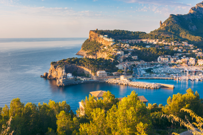
-
Palma Cathedral (La Seu)
This magnificent Gothic cathedral dominates Palma’s skyline and represents one of Spain’s most impressive religious buildings. Construction began in 1229 but wasn’t completed until 1601, spanning nearly four centuries of architectural evolution.
The interior houses 61 stained glass windows, including the spectacular eastern rose window known as the “Gothic Eye” which, when morning sunlight passes through it, creates a mesmerizing light show called “the eight festival.”
Antoni Gaudí contributed to a renovation between 1904-1914, adding elements like a massive crown-of-thorns canopy above the altar. The cathedral sits atop what was once a mosque, and some Islamic architectural elements remain visible in its structure.
-
Serra de Tramuntana
This UNESCO-protected mountain range runs 90km along Mallorca’s northwestern coast, reaching heights of 1,445 meters at Puig Major. The landscape features dramatic limestone formations, terraced hillsides originally built by Arab settlers, and ancient olive groves with trees over 1,000 years old.
The mountains create their own microclimate, often significantly cooler and wetter than the rest of the island. Historic manor houses called “possessions” dot the landscape, many now converted to boutique hotels.
The GR221 “Dry Stone Route” offers a multi-day hiking experience connecting the range’s most beautiful villages, including Valldemossa (where Chopin and George Sand famously spent a winter) and Deià (longtime home to poet Robert Graves).
-
Cuevas del Drach (Dragon Caves)
These spectacular limestone caves extend for 1.2km and descend to a depth of 25 meters below ground. Their formation began during the Miocene epoch, roughly 5.3 to 23 million years ago. The highlight is Lake Martel, one of the world’s largest underground lakes at 115 meters long and 30 meters wide.
Daily classical music concerts are performed by musicians on illuminated boats that glide across the lake, creating a magical atmosphere enhanced by the caves’ extraordinary acoustics. The caves maintain a constant temperature of 21°C and humidity of 80% year-round.
The name “Dragon” derives from a medieval legend claiming a dragon lived within who protected a treasure.
-
Sóller and the Vintage Train
The wooden vintage train connecting Palma to Sóller was inaugurated in 1912 to transport citrus fruits from the fertile Sóller valley to Palma’s port. The journey spans 27.3km, passing through 13 tunnels and across several viaducts. The carriages maintain their original early 20th-century wooden interiors. Sóller itself sits in a natural bowl surrounded by mountains, creating its unique microclimate ideal for citrus cultivation.
The town’s architecture shows distinctive Modernist influences due to returning emigrants who had made fortunes in France. The adjoining Port de Sóller, connected by a historic tram, features a horseshoe bay with warm, shallow waters perfect for families. The valley produces distinctive sweet oranges used in the local Angel d’Or liqueur.
-
Alcúdia Old Town
Surrounded by medieval walls that stretch for 1.5km and feature 26 towers and two main gates, Alcúdia offers one of the best-preserved historic centers in Mallorca. The walls were built in the 14th century after King Jaume II ordered the creation of a fortified town to protect northern Mallorca.
The town grid follows the original Roman layout of the ancient city of Pollentia, established in 123 BCE, whose ruins lie just outside the walls. The weekly market, held since medieval times, takes over the old town every Tuesday and Sunday, filling the narrow streets with stands selling local produce, crafts, and clothing.
Nearby Alcúdia Bay features a 3.4km white sandy beach with shallow waters.
-
Cala Mondragó
This natural park encompasses 785 hectares of protected land, established in 1992 to preserve one of Mallorca’s most pristine coastal areas. The park contains various ecosystems including wetlands that attract over 70 bird species, Mediterranean forest, and coastal formations.
The two main beaches, S’Amarador and Mondragó, are connected by a wooden walkway that follows the coastline. The unusual white sand comes from crushed seashells rather than quartz. Between the beaches rises a limestone headland honeycombed with caves once used by smugglers.
Inland freshwater pools form during rainy seasons, creating critical habitats for amphibians including the endangered Mallorcan midwife toad, which exists nowhere else on Earth.
Menorca
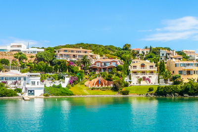
-
Ciutadella
This former capital exudes aristocratic charm through its network of medieval streets and elegant noble houses with distinctive Italianate architecture. The city was founded by Carthaginians in the 4th century BCE. Its most dramatic historical moment came in 1558 when Ottoman pirates sacked the city, enslaving thousands of residents.
The Plaça des Born, once used for medieval tournaments, now forms the elegant heart of the old quarter with its 19th-century obelisk commemorating defenders against Turkish invasions. The Gothic cathedral, built on the site of a mosque, contains an ornate organ with 3,000 pipes dating from 1800.
Ciutadella’s port is actually a narrow, 1km-long natural inlet carved by water erosion over millennia, creating a fjord-like appearance rare in the Mediterranean.
-
Naveta des Tudons
This megalithic burial chamber resembles an upturned boat (“naveta” means “little ship”) and dates from 1200 BCE, making it one of Europe’s oldest intact buildings. The structure stands 4.5 meters high and 14.5 meters long, constructed entirely without mortar using precisely fitted stones weighing up to 2 tons.
When excavated in 1975, archaeologists discovered the remains of at least 100 individuals inside, along with bronze bracelets, pottery, and buttons carved from bone. The naveta represents the advanced engineering capabilities of the Talayotic culture, Menorca’s prehistoric inhabitants. The site’s astronomical alignment suggests it had calendrical significance beyond its funerary purpose, with its entrance oriented to capture the midwinter sunset.
-
Monte Toro
Rising 358 meters, this is Menorca’s highest point and has been considered a sacred site since prehistoric times. According to legend, a bull (toro) led monks to the summit where they discovered a statue of the Virgin Mary.
The current sanctuary dates from the 17th century, though religious buildings have existed on the site since at least the 13th century. The monastery was once home to Augustinian monks until religious orders were expelled from Spain in 1835. The summit offers 360-degree views encompassing the entire island – on clear days, Mallorca is visible to the west and, occasionally, the Catalonian mainland.
The site includes a 19th-century defensive tower used during the Napoleonic Wars and Spanish Civil War.
-
Cala Macarella and Macarelleta
These twin coves represent the postcard image of Menorca’s southern coast. Macarella, the larger bay, features white sand composed of rounded quartz particles that give the water its intense turquoise color. Macarelleta, accessible via a 15-minute cliff path, is smaller and more intimate, nestled between 30-meter limestone cliffs.
The surrounding forests contain wild olive trees estimated to be over 500 years old. The area has strict environmental protections – in summer, access is limited and must be reserved in advance to prevent overcrowding. The waters between these coves host extensive Posidonia oceanica meadows, a flowering underwater plant crucial for Mediterranean marine life that releases large amounts of oxygen, earning it the nickname “the lungs of the Mediterranean.”
-
Mahón Harbor
This natural port stretches 5.5km inland and reaches depths of up to 30 meters, making it the Mediterranean’s deepest natural harbor. The harbor’s strategic value led to British occupation from 1708-1756 and 1763-1782, during which they established the naval base that influenced the town’s Georgian architecture – buildings with sash windows and distinctive doorways remain from this period. The unusual English influence is also evident in Mahón’s traditional food, including mayonnaise (which may originate from here as “salsa mahonesa”) and gin production. The harbor contains several islands, including Isla del Rey with its former British military hospital now being restored as a cultural center, and Isla de Lazareto, a quarantine station built in a perfect octagon.
Ibiza
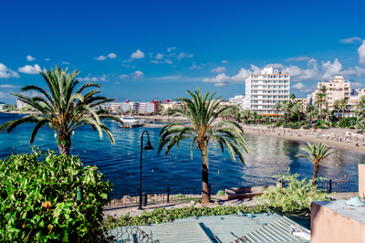
-
Dalt Vila (Ibiza Old Town)
This UNESCO World Heritage fortified acropolis sits on a hill overlooking Ibiza Town and the Mediterranean. The impressive Renaissance walls, built between 1554-1585 to defend against Ottoman pirates and French attacks, extend for 2.5km and incorporate seven bastions.
The defensive system was designed by Italian engineer Giovanni Battista Calvi under orders from King Felipe II, representing the latest military architecture of its time. Within the walls, layers of history are visible: Phoenician settlement remains (founded in 654 BCE), Roman artifacts, Islamic street patterns, and medieval structures.
The former Governor’s House now contains a fascinating archaeological museum with Punic and Roman artifacts discovered throughout the island. The Cathedral of Our Lady of the Snows at the summit contains Gothic, Baroque, and Neoclassical elements, reflecting centuries of reconstruction.
-
Es Vedrà
This uninhabited limestone monolith rises dramatically 382 meters from the sea and generates countless legends. Some claim it’s the tip of the lost continent of Atlantis, while others identify it as the island of the Sirens from Homer’s Odyssey. The rock has a high concentration of minerals that creates magnetic anomalies, reportedly affecting compasses and electronic equipment nearby.
Declared a nature reserve in 2002, the islet hosts a unique ecosystem including rare Eleonora’s falcons, wild goats descended from a population introduced in the 1930s, and endemic lizards found nowhere else.
The best viewing points are from Cala d’Hort beach or the Torre des Savinar, a 16th-century watchtower. Mystical properties attributed to Es Vedrà have attracted spiritual seekers, with the area considered an energy vortex similar to Sedona or Machu Picchu.
-
Las Salinas Beach
This iconic 1.5km stretch of fine white sand forms part of the Ses Salines Natural Park, which encompasses valuable salt flats that have been harvested since Phoenician times (7th century BCE). The salt industry shaped Ibiza’s economy and culture for centuries, with the salt considered among the Mediterranean’s finest.
Behind the beach, pine forests containing trees over 200 years old provide shade and habitat for numerous bird species. The beach gained international fame in the 1960s as a hippy gathering spot, and later evolved into a fashionable destination with beach clubs like Sa Trinxa playing distinctive Balearic beat music that influenced global electronic music trends.
The crystal-clear waters contain especially high salinity, providing exceptional buoyancy for swimmers and nurturing extensive Posidonia seagrass meadows that create the water’s remarkable clarity.
-
Cala d’Hort
This small but dramatic beach faces directly toward Es Vedrà, creating one of the Mediterranean’s most photographed views. The beach combines golden sand with pebbles and features unusually clear water due to the rocky seabed. Traditional fishermen’s huts called “varaderos” line one side of the cove, with some still actively used by local fishing families who serve their catch in simple restaurants directly behind the beach.
Archaeological remains of a Punic-Roman settlement and necropolis discovered nearby indicate this cove has attracted human settlement for over 2,000 years. The clifftop area contains a prehistoric site called Ses Païsses de Cala d’Hort with stone ruins dating to the Bronze Age, suggesting this viewpoint toward Es Vedrà held spiritual significance for ancient inhabitants.
-
Santa Eulària des Riu –
This sophisticated town is centered around Ibiza’s only river, which made it historically important for water-powered mills (five restored mills can be visited along a riverside walk). The town’s symbolic center is Puig de Missa, a fortified hill crowned by a blindingly white 16th-century church that served as a refuge during pirate attacks.
Within the church complex, the Ethnographic Museum displays traditional island crafts, clothing, and a complete reconstruction of a traditional farmhouse interior. The town became a literary and artistic colony in the 1930s, with writers like Walter Benjamin spending time here. Las Dalias hippy market, established in 1954, has grown into one of the island’s major attractions, featuring over 200 stalls selling handmade jewelry, clothing, and artwork every Saturday throughout the year.
Formentera
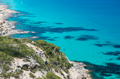
-
Ses Illetes Beach
This extraordinary sandbar stretches north toward Ibiza, creating a double-sided beach where visitors can experience sunrise on the east side and sunset on the west without moving more than 100 meters. The area forms part of the Ses Salines Natural Park shared with southern Ibiza. The sand is composed of crushed seashells and fragments of Posidonia seagrass balls that wash ashore, giving it a uniquely soft texture.
The water clarity is exceptional, with visibility often exceeding 30 meters due to the absence of plankton in these nutrient-poor waters. The beach can only be reached by bicycle, foot, or public bus, as private vehicles are restricted to preserve its natural condition.
Small wooden chiringuito beach bars serve fresh fish and traditional dishes using ingredients that must be brought daily from the main port, as no permanent structures are permitted within the protected area.
-
La Mola Lighthouse
Standing on 120-meter cliffs at Formentera’s eastern end, this lighthouse was built in 1861. Its dramatic setting inspired Jules Verne’s novel “Hector Servadac,” in which he described it as “the lighthouse at the end of the world” (although this nickname is more commonly associated with a lighthouse in Tierra del Fuego that Verne never visited). The current structure replaced an earlier lighthouse destroyed by lightning.
The surrounding plateau of La Mola contains some of the island’s oldest settlements and distinctive architecture including circular stone huts called “casetes de vinya” once used by vineyard workers. A traditional craft market operates nearby on Wednesdays and Sundays, founded by hippies who settled in this remote area in the 1960s, drawn by its isolation and spectacular natural beauty.
-
Ses Salines Natural Park
This protected area encompasses 3,000 hectares of land and sea across southern Ibiza and northern Formentera, connected by an underwater plateau where the Posidonia oceanica seagrass meadows reach their most developed state worldwide (recognized by UNESCO as World Heritage). These underwater “forests” can live for thousands of years – some existing colonies began growing 8,000 years ago – making them potentially Earth’s oldest living organisms.
The park’s salt pans produce around 12,000 tons of salt annually using methods largely unchanged since Phoenician times. The hypersaline conditions attract over 200 bird species, including substantial flamingo populations that create spectacular pink displays during migration seasons.
The underwater ecosystem supports over 400 plant species and 1,000 animal species, many of them endangered Mediterranean endemics found nowhere else.
-
Es Pujols
This is Formentera’s only purpose-built resort, yet it maintains a distinctive laid-back character compared to larger Mediterranean destinations. The town centers around a small fishing harbor that continues to support working fishermen who supply the waterfront restaurants with daily catches.
The main street transforms into a pedestrian market each evening during summer, with artisans displaying handcrafted leather goods, jewelry, and clothing that reflect Formentera’s bohemian heritage. The surrounding beaches feature unusual rock formations called “marès” – fossilized sand dunes from the Quaternary period that have solidified into porous limestone used in traditional buildings across the island.
Es Pujols became an early center for European tourism in the 1960s, attracting musicians including Pink Floyd and Chris Rea, who wrote songs inspired by the island’s atmosphere.
-
Cap de Barbaria Lighthouse
This remote lighthouse marks Formentera’s southernmost point, where Europe ends – the next land is Algeria, 100 miles across the Mediterranean. Built in 1971, the lighthouse itself is less impressive than its setting: a flat, windswept limestone landscape reminiscent of lunar terrain, punctuated by twisted juniper trees shaped by constant winds.
Prehistoric remains discovered nearby include a Bronze Age settlement dating to 1600 BCE. Several scenes from Julio Medem’s film “Sex and Lucia” were filmed here, bringing the location international recognition. Near the lighthouse, a small hole in the ground leads to a natural cave called “the cave of faxes” that opens onto the cliff face, offering a framed view of the Mediterranean from within the earth.
Sunset here is particularly memorable as the sun appears to sink directly into the open sea with no land on the horizon.
Cabrera Archipelago
- Cabrera National Park – Spain’s only maritime-terrestrial national park encompasses a 19-island archipelago that has served as a military zone for most of its modern history, preserving it from development.
Human habitation has been limited to a small garrison and occasional prisoners – during the Napoleonic Wars, 9,000 French prisoners were abandoned here, with only 3,600 surviving the harsh conditions. This troubled history contrasts with extraordinary natural values: the islands host 450 plant species including 30 endemics found nowhere else. The surrounding waters contain exceptional marine biodiversity with coral formations typically found much deeper in other parts of the Mediterranean.
The Blue Cave (Cova Blava) creates an otherworldly blue illumination when sunlight refracts through an underwater entrance. Byzantine ruins on the main island include a 5th-century basilica, while a 14th-century castle built to combat piracy dominates the harbor. Strict visitor quotas (maximum 300 people daily) preserve the island’s pristine condition.
Best time to visit Spain
Spain offers diverse experiences across its regions throughout the year. The ideal visiting time depends on your preferred activities, regional destinations, and tolerance for different weather conditions and tourist densities.
High Season (June-August)
The summer months constitute Spain’s peak tourist season, characterized by:
- Temperatures often exceeding 35°C (95°F) in central and southern regions
- Coastal areas experiencing more moderate temperatures around 30°C (86°F)
- Highest accommodation rates and largest crowds at major attractions
- Vibrant festivals including La Tomatina and numerous local fiestas
- Excellent beach conditions along both Mediterranean and Atlantic coasts
This period is optimal for beach holidays, particularly in northern coastal regions like Galicia, Asturias, and the Basque Country, which enjoy pleasant summer temperatures without the extreme heat of southern Spain.
Shoulder Seasons (April-May, September-October)
Many travel experts consider the shoulder seasons the optimal time to visit Spain, offering:
- Mild temperatures ranging from 15-25°C (59-77°F)
- Significantly reduced crowds at major attractions
- Accommodation prices approximately 30-40% lower than peak season
- Spring blooms (April-May) or harvest season activities (September-October)
- Comfortable conditions for city exploration and cultural activities
- Spring Holy Week (Semana Santa) celebrations or autumn wine harvests
These months provide an excellent balance of good weather, reduced tourism pressure, and cultural opportunities, particularly for exploring cities like Madrid, Barcelona, Seville, and Granada.
Low Season (November-March)
Winter in Spain offers distinct advantages for certain types of travelers:
- Significantly reduced tourist numbers at major sites
- Lowest accommodation and transportation rates
- Mild winter temperatures in southern regions (Andalusia, Valencia)
- Skiing opportunities in the Sierra Nevada, Pyrenees, and other mountain ranges
- Christmas markets and traditional winter celebrations
- Authentic cultural experiences with predominantly local participants
The exception is the Christmas/New Year period and Carnival season (February/March), when domestic tourism increases significantly.
Regional Considerations
Northern Spain (Galicia, Asturias, Basque Country)
Best visited from June to September when rainfall is reduced and temperatures are pleasant (18-25°C/64-77°F).
Central Spain (Madrid, Castilla y León, Extremadura)
Spring and fall offer the most comfortable conditions. Summer brings intense heat, while winter can be cold with occasional snow.
Mediterranean Coast (Catalonia, Valencia, Balearic Islands)
May-June and September-October provide excellent conditions with warm temperatures and reduced crowds compared to the July-August peak.
Southern Spain (Andalusia)
March-May and September-November offer ideal temperatures. Summer months can be extremely hot, making sightseeing uncomfortable, though coastal areas like Málaga remain pleasant.
Canary Islands
These islands boast a year-round spring-like climate, making them an excellent winter sun destination when continental Europe experiences colder temperatures.
Special Events Worth Planning Around
- Las Fallas (Valencia) – Mid-March
- Semana Santa (nationwide, especially Seville) – March/April
- Feria de Abril (Seville) – April/May
- San Fermín/Running of the Bulls (Pamplona) – July
- La Tomatina (Buñol) – Last Wednesday in August
- Wine harvests (La Rioja, Ribera del Duero) – September/October
Activities to do in Spain
Cultural Immersion
Visit World-Class Museums
Spain houses some of the world’s finest art collections. The Prado Museum in Madrid displays masterpieces by Velázquez, Goya, and El Greco, while the nearby Reina Sofía Museum features Picasso’s powerful “Guernica.” In Bilbao, the titanium-clad Guggenheim Museum represents a pinnacle of contemporary architecture housing modern and contemporary works. These institutions offer guided tours that provide valuable context to Spain’s artistic legacy.
Explore Historic Architecture
Spain’s architectural heritage spans millennia, from the Roman aqueduct in Segovia to the Moorish splendor of Andalusia’s Alhambra Palace. The unfinished masterpiece of Antoni Gaudí, Barcelona’s Sagrada Familia, demonstrates Spain’s continuing architectural innovation. The medieval Santiago de Compostela Cathedral marks the culmination of the famous pilgrimage route. Visitors should allocate sufficient time at these sites to appreciate their historical significance and architectural details.
Attend Flamenco Performances
The passionate art of flamenco, recognized by UNESCO as Intangible Cultural Heritage, combines guitar music, singing, hand clapping, and expressive dance. Traditional venues called “tablaos” in cities like Seville, Granada, and Madrid offer authentic performances. For a more immersive experience, visitors can attend flamenco festivals such as the Bienal de Flamenco in Seville or take introductory classes to understand this complex art form’s technical elements.
Culinary Experiences
Tapas Tours
Spain’s tapas culture represents a distinctive approach to dining that emphasizes variety and socialization. In cities like Madrid, Barcelona, and San Sebastián, guided tapas tours introduce visitors to regional specialties and dining customs. These tours typically visit multiple establishments, allowing participants to sample diverse dishes while learning about their history and preparation.
Participate in Food Workshops
Cooking classes focused on Spanish cuisine provide insights into traditional techniques and ingredients. Paella workshops in Valencia, the dish’s birthplace, are particularly popular. Wine enthusiasts can arrange vineyard tours in regions like La Rioja, Ribera del Duero, and Priorat, often including guided tastings and explanations of production methods. Most culinary schools and wineries offer English-language instruction for international visitors.
Visit Food Markets
Spanish markets serve as cultural institutions where local culinary traditions are preserved and celebrated. Barcelona’s La Boqueria, Madrid’s Mercado de San Miguel, and Valencia’s Central Market offer opportunities to observe Spanish food culture and sample regional specialties. Many markets now feature counters where visitors can enjoy prepared dishes showcasing market products.
Outdoor Activities
Hiking the Camino de Santiago
The Camino de Santiago (Way of St. James) comprises various pilgrimage routes leading to Santiago de Compostela. The most popular path, the French Way, crosses northern Spain through diverse landscapes. While traditionally a religious pilgrimage, the route now attracts many secular hikers seeking a meaningful journey. Walkers can complete sections of varying lengths, with established infrastructure supporting travelers along the route.
Beach Experiences
Spain’s 8,000 kilometers of coastline feature diverse beach experiences. The Costa Brava in Catalonia offers dramatic rocky coves, while Andalusia’s Costa del Sol provides reliable sunshine and developed resorts. The Atlantic beaches of Galicia and the Basque Country present more rugged conditions, popular with surfers. The Balearic and Canary Islands extend these offerings with exceptional Mediterranean and subtropical beaches respectively.
Mountain Activities
Spain’s varied mountain ranges support year-round activities. The Pyrenees and Sierra Nevada offer winter skiing and summer hiking. The Picos de Europa in northern Spain features dramatic limestone formations and diverse wildlife. Most mountain regions maintain well-marked trail systems and visitor centers that provide information on routes suitable for different experience levels.
Regional Specialties
Andalusia: Horse Shows and Sherry Tasting
In Jerez de la Frontera, the Royal Andalusian School of Equestrian Art presents performances demonstrating classical horsemanship. The surrounding sherry triangle (Jerez, Sanlúcar de Barrameda, and El Puerto de Santa María) offers bodega tours exploring the production of these distinctive fortified wines. These experiences connect visitors to Andalusia’s aristocratic traditions and agricultural heritage.
Catalonia: Human Tower Building
The Catalan tradition of “castells” (human towers) represents a remarkable feat of community cooperation and physical skill. Major festivals in cities like Tarragona, Vilafranca del Penedès, and Valls feature competing teams constructing towers that can reach up to ten levels. Visitors can observe this practice, which UNESCO has recognized as Intangible Cultural Heritage, during local festivals primarily from May to November.
Valencia: Las Fallas Festival
This extraordinary celebration in March transforms Valencia with over 700 elaborate satirical sculptures (fallas) displayed throughout the city before being ceremonially burned. The festival includes daily fireworks displays, parades in historical costumes, and community gatherings. Visitors should secure accommodations well in advance, as this internationally renowned event attracts substantial crowds.
Urban Experiences
City Walking Tours
Many Spanish cities offer themed walking tours highlighting historical events, architectural styles, or literary connections. In Madrid, tours may focus on the Spanish Civil War or the Habsburg dynasty. Barcelona offers routes exploring Gaudí’s works or the medieval Gothic Quarter. These tours, available through official tourism offices and private companies, often provide perspectives not covered in standard guidebooks.
Bicycle Tours
Cities including Seville, Valencia, and Barcelona have developed extensive bicycle infrastructure, making cycling an efficient and enjoyable way to explore urban areas. Public bicycle sharing systems or rental shops provide access to equipment, while specialized tour operators offer guided experiences focusing on particular neighborhoods or themes. This approach allows visitors to cover more ground than walking while maintaining a connection to the urban environment.
Evening Paseo Participation
The evening stroll (paseo) remains an important social ritual in many Spanish towns and cities. This casual promenade typically occurs before dinner, around 7-9 PM, when residents walk through main streets, plazas, and parks, often stopping to socialize. Visitors can participate in this authentic daily custom simply by joining the flow of pedestrians along popular routes such as Madrid’s Paseo del Prado or Salamanca’s Plaza Mayor.
Spain public transportation guide
Spain offers a comprehensive and efficient transportation infrastructure that effectively connects its diverse regions while providing visitors and residents with multiple travel options to suit various needs and preferences.
The national railway system, operated primarily by RENFE, serves as the backbone of Spain’s public transportation network. The high-speed AVE trains connect major cities at speeds reaching 310 km/h, significantly reducing travel times—Madrid to Barcelona takes just 2.5 hours, while Madrid to Seville requires only 2.5 hours. Regional and commuter train services complement these high-speed routes, ensuring connectivity to smaller destinations.
Spain’s road network is equally impressive, with over 17,000 kilometers of autopistas (toll highways) and autovías (free highways) providing excellent connections between cities. Intercity bus services, often more economical than trains, serve both major urban centers and remote villages with remarkable frequency and reliability.
Within cities, public transportation is typically well-developed, with Madrid and Barcelona offering extensive metro systems that rank among Europe’s best. Most urban areas maintain comprehensive bus networks, while cities like Seville, Valencia, and Bilbao have invested in modern tram systems. Many coastal cities also operate seasonal ferry services.
For travelers seeking flexibility, rental cars are widely available, though driving in historic city centers can be challenging due to narrow streets and limited parking. Ride-sharing services and taxis operate in most urban areas, providing convenient point-to-point transportation.
Spain’s commitment to sustainable mobility is evident in the growing bicycle infrastructure in cities like Seville and Barcelona, where extensive bike lane networks and public bicycle sharing systems encourage environmentally friendly travel options.
With 46 airports receiving international flights and major ports serving Mediterranean and Atlantic shipping routes, Spain maintains excellent global connectivity, facilitating tourism and commerce throughout the country.
Major Spanish Transportation Hubs
Major Airports
Madrid
Madrid-Barajas Adolfo Suárez Airport (MAD)
- Spain’s largest airport with 4 terminals
- Hub for Iberia and Air Europa
- Connected to the city by Metro Line 8
Barcelona
Barcelona-El Prat Airport (BCN)
- Two terminals handling about 50 million passengers yearly
- Located 12km from city center
- Connected by metro, train, and airport bus
Málaga
Málaga-Costa del Sol Airport (AGP)
- Main gateway to Andalusia and Costa del Sol
Palma de Mallorca
- Palma de Mallorca Airport (PMI)
Alicante
Alicante-Elche Airport (ALC)
- Gateway to Costa Blanca
Other Significant Airports
- Gran Canaria Airport (LPA) – Canary Islands’ busiest airport
- Valencia Airport (VLC) – Serves Spain’s third-largest city
- Seville Airport (SVQ) – Main airport for western Andalusia
- Bilbao Airport (BIO) – Principal airport for northern Spain
Major Train Stations
For more details visit: https://spainrail.com/en
Madrid
Madrid Atocha
- Spain’s largest railway station
- Main hub for high-speed AVE services
- Features a tropical garden in its concourse
- Connects to Metro Line 1
Madrid Chamartín
- Second major station in Madrid
- Serves northern destinations and international routes
Barcelona
Barcelona Sants
- Barcelona’s primary railway station
- Hub for high-speed services to Madrid, Valencia, and France
- Connected to metro lines L3 and L5
Barcelona França
- Historic station serving regional routes
- Architectural landmark with ornate design
Seville
Seville Santa Justa
- Main station for Andalusia
- Serves high-speed connections to Madrid
- Modern facility opened for Expo ’92
Valencia
Valencia Joaquín Sorolla
- High-speed rail terminal
- Connected to Valencia Nord by shuttle
Valencia Nord
- Historic main station for regional services
- Notable modernist architecture
Other Key Stations
- Málaga María Zambrano – Andalusian hub with shopping center
- Zaragoza Delicias – Major station on Madrid-Barcelona line
- Córdoba Central – Important junction on southern high-speed network
- Alicante Terminal – Modern station for southeastern Spain
Major Sea Ports
Barcelona
- Spain’s leading cruise port
- Direct ferry connections to Balearic Islands, Italy, and North Africa
- Seven passenger terminals with modern facilities
Valencia
- Growing cruise destination
- Regular ferry services to Balearic Islands and Italy
- Modern passenger terminal with good city connections
Bilbao
- Major northern seaport
- Ferry connections to Portsmouth (UK)
- Cruise terminal located in Getxo, 15km from city center
Málaga
- Southern Spain’s principal cruise port
- Eastern terminal for Mediterranean cruises
- Located walking distance from city center
Balearic Islands
Palma de Mallorca
- Mediterranean’s third busiest cruise port
- Major ferry hub connecting to mainland Spain and other islands
Ibiza
- Regular ferry services to mainland and other Balearic Islands
- Growing cruise destination
Canary Islands
Santa Cruz de Tenerife
- Main port for western Canary Islands
- Ferry connections between islands and to Cadiz on mainland
Las Palmas (Gran Canaria)
- Principal port for eastern Canary Islands
- Major cruise ship destination
Algeciras
- Strategic position near Gibraltar
- Ferry connections to Ceuta, Tangier, and Morocco
- Important link between Europe and Africa
Barcelona
For details visit: https://www.barcelona.de/en/barcelona-public-transport.html
Public Transportation in Barcelona
Barcelona offers one of Europe’s most comprehensive public transportation systems, allowing residents and visitors to navigate the city and surrounding areas efficiently. Here’s a detailed overview of all transportation options available:
Metro (Underground)
The Barcelona Metro is the backbone of the city’s public transportation system, operated by TMB (Transports Metropolitans de Barcelona).
Key details:
- 8 numbered lines (L1, L2, L3, L4, L5, L9N, L9S, L10N, L10S, L11, FM) and 165 stations covering most of the city
- Line L9/L10 connects the airport to the city
- Operating hours: Sunday-Thursday 5:00 AM-12:00 AM; Friday 5:00 AM-2:00 AM; Saturday 24-hour service
- Trains typically arrive every 2-5 minutes during peak hours
- Official website: https://www.tmb.cat/en/barcelona/metro/lines#iss=https%3A%2F%2Fauth.tmb.cat%2Fauth%2Frealms%2Ftmb
Buses
Barcelona’s bus network complements the metro, reaching areas not covered by rail transport.
Regular bus service:
- Operated primarily by TMB
- Over 230 routes throughout the city
- Most daytime buses operate from 5:00 AM-10:00 PM
- Over 30 Night buses (Nitbus) routes operate from 10:00 PM-5:00 AM, with routes prefixed with ‘N’.
- Electronic displays at stops show waiting times
- Official website: https://www.tmb.cat/en/barcelona/buses/lines#iss=https%3A%2F%2Fauth.tmb.cat%2Fauth%2Frealms%2Ftmb
Tourist Bus:
- Barcelona Bus Turístic offers hop-on-hop-off service on three routes
- Audio guides in multiple languages
Tram
Barcelona’s modern tram system consists of two networks that are not yet connected:
Trambaix (T1, T2, T3):
- Serves the southwestern part of the city
- Connects Plaça Francesc Macià with Baix Llobregat
Trambesòs (T4, T5, T6):
- Serves the northeastern areas
- Connects Glòries with Sant Adrià and Badalona
FGC (Ferrocarrils de la Generalitat de Catalunya)
The FGC is a separate railway network operating both urban and suburban services:
- Barcelona-Vallès Line: Connects to towns like Sant Cugat and Terrassa
- Llobregat-Anoia Line: Serves areas southwest of Barcelona
- Integrated with the TMB metro system for urban travel
Rodalies (Cercanías)
Rodalies is the commuter rail network operated by Renfe, connecting Barcelona to nearby towns and cities:
- 8 lines (R1-R4, R7, R8, R12, R13, R14-R17)
- Covers the wider Barcelona metropolitan area and beyond
- Important for regional connections
- Also serves Barcelona Airport (Terminal 2)
Funiculars and Cable Cars
Barcelona’s unique topography has led to several vertical transport options:
Funicular de Montjuïc:
- Connects the Paral·lel metro station to Montjuïc hill
- Operated by TMB and integrated with the metro network
Telefèric de Montjuïc:
- Cable car connecting the funicular station to Montjuïc Castle
- Offers panoramic views of the city
Telefèric del Port:
- Crosses the port area, connecting Montjuïc with Barceloneta
- Primarily a tourist attraction
Taxis
Barcelona’s taxi service is extensive and reliable:
- Black and yellow vehicles
- Over 10,000 licensed taxis
- Can be hailed on the street, found at taxi stands, or booked through apps
- Main companies include Radio Taxi Barcelona and Taxi Ecològic
Ferry and Port Services
Barcelona’s position on the Mediterranean means it also has maritime transportation:
- Local ferry services connecting Barcelona with Balearic Islands
- Cruise terminal connections
- Companies include Baleària, Trasmediterránea, and Grimaldi Lines
Transportation Cards and Integrated Ticketing
Barcelona’s public transportation uses an integrated fare system managed by ATM (Autoritat del Transport Metropolità):
T-casual:
- 10 single journeys on any form of transport
- Valid for one transportation zone
T-usual:
- Unlimited journeys for 30 consecutive days
- Personal and non-transferable
T-grup:
- 70 journeys for 30 consecutive days
- Can be used by multiple people
T-dia:
- Unlimited journeys for 24 hours
Hola Barcelona Travel Card:
- Tourist card with unlimited journeys for 48, 72, 96, or 120 hours
- Includes airport connections
Barcelona Card:
- Includes free public transport plus museum and attraction discounts
Transportation Apps
Several official apps help navigate Barcelona’s transportation system:
- TMB App: Real-time information for metro and bus services
- AMB Mobilitat: Comprehensive mobility app for the metropolitan area
- Citymapper: Third-party app with excellent coverage of Barcelona
Madrid
Madrid boasts one of Europe’s most extensive and efficient public transportation networks, serving both the city center and the greater metropolitan area. The system is characterized by its integration, cleanliness, and comprehensive coverage.
The Madrid Metro forms the backbone of the city’s public transportation system and stands as one of the most extensive metro networks in the world.
Key features:
- 12 numbered lines plus a branch line (Line R)
- 302 stations covering 294 kilometers of track
- Serves both the city center and suburban areas
- Operating hours: Generally 6:00 AM-1:30 AM daily
- Peak hour frequency: Trains every 2-4 minutes
- Managed by Metro de Madrid, a public company owned by the Community of Madrid
- Official website: https://www.metromadrid.es/en
Special services:
- Line 8 provides direct access to Madrid-Barajas Airport
- Line R (Ramal) connects Opera and Príncipe Pío stations
- ExpressMadrid airport express service within the metro system
The Metro system uses a color-coding scheme for easy navigation, with each line designated by both a number and a color on all maps and signage.
EMT Madrid Bus Network
The Empresa Municipal de Transportes de Madrid (EMT) operates the city’s comprehensive bus network.
Regular bus service:
- More than 200 routes covering the entire city
- Fleet of approximately 2,000 buses
- Most day routes operate from approximately 6:00 AM-11:30 PM
- Many routes serve areas not covered by Metro
- Electronic displays at stops with real-time arrival information
- Official website: https://www.emtmadrid.es/EMTBUS/Mi-linea?lang=en-GB
Special bus services:
- Night buses (Búhos): 26 routes operating from 11:45 PM-6:00 AM
- Airport Express: 24-hour service connecting Madrid-Barajas Airport with the city center
- University service lines during academic periods
- Seasonal services for events and holidays
Cercanías Madrid (Commuter Rail)
Cercanías is Madrid’s commuter rail network, operated by Renfe, Spain’s national railway company.
Network details:
- 9 lines (C-1 to C-10, with C-6 split into C-6 and C-6a)
- 89 stations covering approximately 370 kilometers
- Connects central Madrid to surrounding suburbs and cities
- High frequency during peak hours (trains every 5-10 minutes)
- Fully integrated with Metro and bus networks
- Serves Madrid-Barajas Airport (Terminal 4) via line C-1
- Official website: https://www.renfe.com/es/en/cercanias/cercanias-madridCercanías Madrid
Cercanías trains are particularly useful for longer journeys within the Community of Madrid and for reaching outlying areas such as Alcalá de Henares, Aranjuez, or El Escorial.
Light Rail/Metro Ligero
Madrid’s light rail system complements the Metro in areas where full metro service is not available.
Network information:
- 4 lines: ML-1, ML-2, ML-3, and ML-4
- 38 stations covering approximately 35 kilometers
- Modern, accessible tram-like vehicles
- Operated by Metro de Madrid
- ML-1 serves Madrid’s northern suburbs (Pinar de Chamartín to Las Tablas)
- ML-2 and ML-3 serve western areas (Colonia Jardín to Puerta de Boadilla and Puerta de Arganda)
- ML-4 connects Parla with the Cercanías network
Taxis and Ride-Sharing Services
Madrid has extensive taxi services throughout the city.
Taxi information:
- White vehicles with a red diagonal stripe and the city’s coat of arms
- Over 15,000 licensed taxis
- Can be hailed on the street, found at taxi stands, or booked via apps
- Fixed fare for airport journeys
- Primary taxi associations: Radio Taxi Independiente, Radio Taxi Gremial, and Tele Taxi
Ride-sharing services:
- Cabify operates in Madrid
- Uber returned to Madrid in 2016 with licensed drivers
- Free Now (previously MyTaxi) app connects to official taxis
Integrated Fare System
Madrid’s public transportation operates under an integrated fare system managed by the Consorcio Regional de Transportes de Madrid (CRTM).
Main ticket types:
- Single tickets (Billete Sencillo): Valid for one journey on one mode of transport
- 10-journey tickets (Metrobús for buses, Metrotren for Cercanías, Bonotren for longer Cercanías journeys)
- Tourist Travel Pass (1, 2, 3, 5, or 7 days): Unlimited travel in selected zones
- Monthly and Annual Travel Passes: Unlimited travel for the period in selected zones
- Public Transportation Card (Tarjeta Transporte Público): Rechargeable smartcard that can hold various ticket types
Zone system:
- Madrid’s transportation network is divided into concentric zones (A through E2)
- Fare costs increase as you travel across more zones
- Zone A covers the city center, while outer zones extend to the limits of the Community of Madrid
Cable Cars (Teleférico de Madrid)
Madrid has a cable car offering a sightseeing experience above the city.
System details:
- Connects Parque del Oeste with Casa de Campo
- 2.5 kilometer route
- Primarily a tourist attraction rather than daily transportation
- Spectacular views of Madrid’s skyline and Royal Palace
- Operated independently from the main public transportation network
Interurban Buses
For travel to suburbs and nearby towns not covered by Metro or Cercanías, Madrid has an extensive interurban bus network.
Network information:
- Multiple operators serving different corridors
- Most routes depart from major transport hubs (Avenida de América, Plaza de Castilla, Moncloa, etc.)
- Green buses (as opposed to EMT’s blue buses)
- Coordinated by the Consorcio de Transportes but operated by private companies
- Companies include Avanza, ALSA, Interbus, and La Veloz
Airport Connections
Madrid-Barajas Airport is well-connected to the city center through multiple transportation options.
Transportation to/from the airport:
- Metro Line 8 connects to Nuevos Ministerios transport hub
- Cercanías line C-1 connects Terminal 4 to Atocha and Chamartín train stations
- EMT Airport Express: 24-hour bus service to Atocha and O’Donnell
- Regular EMT bus routes: Lines 101, 200, and N27 (night bus)
- Fixed-rate taxi service available from designated stands
Transportation Apps
Several official and third-party apps help navigate Madrid’s transportation system.
Recommended apps:
- Madrid Public Transport (official CRTM app)
- Metro de Madrid Official App
- EMT Madrid App (for buses)
- Moovit (comprehensive third-party app)
- Citymapper (covers all Madrid transportation options)
Graneda
Granada, a charming city in Andalusia, southern Spain, has a relatively compact urban layout but offers several public transportation options that serve both locals and the many tourists who visit this historic destination. Although smaller than Madrid or Barcelona, Granada’s transportation system is designed to navigate the city’s unique topography, which includes steep hills and narrow streets in the historic districts.
For more details visit: https://www.puregrenada.com/
Buses – Rober
The primary public transportation network in Granada is the bus system operated by Transportes Rober.
Key details:
- 28 regular daytime routes covering the entire city
- 4 night bus routes (marked with N)
- Special routes for university areas
- Fleet of approximately 180 vehicles
- Modern, air-conditioned buses with low-floor access for accessibility
- Electronic displays at major stops showing waiting times
- Most frequent service on lines 1, 4, and 11
- Operating hours: Generally from 6:30 AM to 11:00 PM (varies by line)
- Night service on weekends and holidays until 2:00 AM
Special services:
- Line C30/C32 (Alhambra Bus): Special routes connecting the city center with the Alhambra palace complex
- Line C35: Special service for the Albaicín historic district
- Line U3: University campus service
LAC (Línea de Alta Capacidad)
The LAC is Granada’s Bus Rapid Transit (BRT) system, which serves as a high-capacity transit corridor through the city center.
Key features:
- 1 line running north-south through the city
- Dedicated bus lanes for most of the route
- Higher frequency than regular lines (every 3-8 minutes)
- Electronic displays with real-time information
- Stations rather than simple stops, with better amenities
- Operated by Transportes Rober
Granada Metro (Metro de Granada)
Opened in 2017, the Granada Metro is a light rail system that serves the city and some surrounding areas.
System details:
- 1 line spanning 15.9 kilometers
- 26 stations
- Connects the city center with surrounding areas including Armilla, Maracena, and Albolote
- Trains every 8-10 minutes during peak hours
- Operating hours: 6:30 AM to 11:00 PM (extended on weekends)
- Operated by Metro de Granada, part of the Junta de Andalucía
- Modern, accessible trains with air conditioning
- Integrated with the bus network for transfers
- Official website: https://metropolitanogranada.es/
Taxi Services
Taxi information:
- White vehicles with the city’s emblem and a green light when available
- Approximately 560 licensed taxis
- Can be hailed on the street, found at taxi ranks, or booked by phone
- Primary taxi associations: Radio Taxi Granada and Tele Taxi Granada
- Fixed rates for certain destinations like the airport
- Phone booking: Radio Taxi Granada (958 280 654), Tele Taxi (958 132 323)
Apps and booking services:
- PideTaxi Granada app
- FreeNow (formerly MyTaxi)
Airport Connections
Federico García Lorca Granada-Jaén Airport (GRX) is located about 17 kilometers west of the city.
Transportation to/from the airport:
- Airport bus (Autocares José González): Regular service between the airport and Granada Bus Station
- Travel time: Approximately 45 minutes
- Taxis available with fixed rates to city center (around €28-30)
- Car rental services at the terminal
Intercity Transportation
For travel beyond Granada to other cities and towns in the region:
Bus services:
- ALSA: Main operator for intercity buses
- Granada Bus Station (Estación de Autobuses de Granada): Central hub for all regional buses
- Routes to major cities like Málaga, Seville, Madrid, and many smaller towns
- Official website: https://www.alsa.com/en/
Train services:
- Renfe operates train services from Granada Station
- High-speed AVE service connects Granada with Madrid (approximately 3 hours)
- Regional services to Almería, Seville, and other Andalusian cities
- Official website: https://www.renfe.com/
Tourist Transportation
Given Granada’s popularity as a tourist destination, there are specific services catering to visitors.
City Tour Train:
- Touristic “train” (wheeled road vehicle resembling a train)
- Circular route passing major tourist attractions
- Hop-on, hop-off service
- Audio guide in multiple languages
- Operated by Granada City Tour
Fare System and Ticketing
Granada uses a relatively simple fare system compared to larger cities.
Main ticket types for buses:
- Single ticket (billete sencillo): Purchased on board, approximately €1.40
- Credibús card: Rechargeable card for multiple journeys with discounts
- Tourist Pass: Unlimited travel for 1 day (€8) or 3 days (€20)
Metro tickets:
- Single journey: €1.35 for one zone
- Round trip: €2.70
- Bonobus cards accepted for combined bus-metro trips
- Consorciada Card: Integrated card for both bus and metro
Integrated fare system:
- Managed by Consorcio de Transporte Metropolitano del Área de Granada
- Allows transfers between metro and buses
- Zone-based pricing for journeys extending beyond the city
Mobile Apps and Online Services
Several apps are available to help navigate Granada’s transportation system:
- Rober Granada: Official app for bus times and routes
- Metro Granada: Official metro app with real-time information
- Moovit: Comprehensive third-party app covering all Granada public transportation
- Google Maps: Reliable for basic navigation and schedules in Granada
Valencia
Public Transportation in Valencia
Valencia, Spain’s third-largest city, offers a comprehensive and well-integrated public transportation system that effectively serves both its historic center and metropolitan area. The network combines traditional and modern transport solutions that reflect Valencia’s unique character as a city that balances history with innovation.
Metrovalencia
Metrovalencia is the backbone of Valencia’s rapid transit system, offering a network that combines underground metro in the city center with surface tram and light rail services extending to suburbs and nearby communities.
Network specifications:
- 10 lines (numbered 1-10) covering approximately 156 kilometers
- 137 stations across the metropolitan area
- Mix of underground metro (in city center) and surface tram/light rail (in suburbs)
- Operated by Ferrocarrils de la Generalitat Valenciana (FGV)
- Operating hours: Generally 5:30 AM-11:30 PM (with extended hours on weekends)
- Frequency varies by line: 5-15 minutes during peak hours
- Lines 3 and 5 provide direct service to Valencia Airport
- Official website: https://www.metrovalencia.es/en/
Line details:
- Lines 1, 2, 3, 5, 7, and 9 operate as traditional metro services
- Lines 4, 6, 8, and 10, known as “tranvía” (tram), provide street-level service
- Line 10 connects the city center with the beach areas and maritime districts
EMT Valencia Bus Network
The Empresa Municipal de Transportes de Valencia (EMT) operates the city’s extensive bus network that complements the metro system by providing more granular coverage of city neighborhoods.
Bus system details:
- Over 60 routes covering Valencia city proper
- Fleet of approximately 480 buses, including standard, articulated, and mini buses
- Extensive night bus service (Nocturno) with routes prefixed with “N”
- Operating hours: Day routes typically 5:30 AM-10:30 PM; night routes 10:30 PM-5:30 AM
- Real-time arrival information available at many stops and via mobile app
- Progressive fleet conversion to environmentally friendly vehicles (electric, hybrid, and CNG)
- Enhanced accessibility features on all modern vehicles
Special services:
- Maritime lines connecting to Las Arenas and Malvarrosa beaches
- Special services during major festivals (Fallas, etc.)
- Tourist routes with commentary (not to be confused with the separate sightseeing buses)
Cercanías Valencia (Commuter Rail)
Cercanías Valencia provides commuter rail service connecting Valencia with surrounding towns and cities, operated by Renfe, Spain’s national railway company.
Network information:
- 6 lines (C-1 through C-6) spanning approximately 252 kilometers
- 66 stations serving the greater Valencia metropolitan area
- Primary stations: Estación del Norte (València Nord) and València-Joaquín Sorolla
- Integrated with metro and bus networks
- Extends to destinations such as Gandía, Utiel, and Castellón
- Serves Valencia Airport via line C-3
MetroBus
MetroBus provides bus services connecting Valencia with its metropolitan area, covering areas not served by Metrovalencia or Cercanías.
System details:
- Over 50 routes operated by various private companies
- Coordinated by the Metropolitan Transport Authority (ATMV)
- Yellow buses distinguish them from EMT’s red buses
- Connect Valencia with over 40 municipalities in the metropolitan area
- Primary terminal at Nuevo Centro interchange
Taxis and Ride-Sharing Services
Valencia has a robust taxi service throughout the city.
Taxi information:
- White vehicles with the distinctive Valencia taxi sign and license number
- Approximately 2,800 licensed taxis
- Can be hailed on street, found at taxi stands, or booked by phone or app
- Primary taxi associations: Radio Taxi and Tele Taxi
- Fixed airport rate (around €20-25 to city center)
- Phone booking: Radio Taxi (963 703 333), Tele Taxi (963 571 313)
- Taxi app: Taxi Valencia
Ride-sharing services:
- Cabify operates in Valencia
- Uber has resumed operations in Valencia with licensed drivers
Electric Scooter Sharing
Several companies offer electric scooter sharing services in Valencia:
Providers include:
- Lime
- Bird
- Dott
- Tier
These services require their respective mobile apps and operate on a per-minute rental basis. The city has established regulations regarding scooter use, including designated parking areas in many locations.
Water Transportation
Given Valencia’s coastal location, there are several maritime transportation options:
Regular services:
- Ferry connections to the Balearic Islands (operated by Baleària and Trasmediterránea)
- Departures from Valencia Port
- Albufera boat tours (traditional wooden boats in the Albufera Natural Park)
- Local water taxis during summer months connecting marina areas
Tourist services:
- Boat tours of Valencia harbor
- Catamaran excursions along the coast
Integrated Fare System
Valencia’s public transportation operates under an integrated fare system coordinated by the Autoritat de Transport Metropolità de València (ATMV).
Primary card types:
- Móbilis: Rechargeable contactless card that can hold various ticket types
- TuiN: Pay-as-you-go system with discounted fares
- SUMA: Multi-operator integrated card allowing transfers between different transport modes
- Single, round-trip, and 10-journey options available
- Zone system with A (city center) through D (outer metropolitan area)
- Special tourist cards offering unlimited travel (1, 2, or 3 days)
- Valencia Tourist Card: Includes public transportation plus museum and attraction discount.
Airport Connections
Valencia Airport (VLC) is located 8 kilometers west of the city center and offers multiple public transportation connections:
Transport options to/from the airport:
- Metro Lines 3 and 5 provide direct service to the city center (approximately 20 minutes)
- Metropolitan buses connect to various destinations
- Taxi service with fixed rates to the city center
- Airport shuttle services to major hotels
- Official airport website: https://www.aena.es/es/valencia.html
Tourist Transportation
Several specialized transportation options cater to tourists:
Valencia Tourist Bus:
- Hop-on, hop-off service operated by Valencia Bus Turistic
- Two routes (historical and maritime)
- Audio guides in multiple languages
Tourist Train:
- Circula por Valencia – a road vehicle resembling a train
- Routes through the historic center
- Ideal for visitors with mobility concerns
- Stops at major attractions
Special Event Transportation
Valencia hosts several major events that receive special transportation arrangements:
Las Fallas (March):
- Extended metro hours
- Special bus routes to fireworks displays and major monuments
- Temporary traffic restrictions in the historic center
Formula 1 Valencia Grand Prix (when held):
- Special shuttle services to the circuit
- Increased frequency on Line A metro to the port area
Concerts and sporting events:
- Enhanced service to Ciutat de les Arts i les Ciències
- Special services to Mestalla Stadium (Valencia CF) and La Fonteta (Valencia Basket)
Mobile Apps and Technology
Several official and third-party apps facilitate navigation of Valencia’s transportation system:
Recommended apps:
- EMT Valencia Official App
- Metrovalencia Official App
- Valenbisi App (for bike-sharing)
- ATMV App (for integrated transport information)
- Moovit and Citymapper (comprehensive third-party apps)
San Sebastian
San Sebastián (Donostia in Basque) is a beautiful coastal city in Spain’s Basque Country that offers a well-organized public transportation system fitting its compact size and topography. Despite being smaller than major Spanish cities, San Sebastián maintains an efficient network that serves both residents and the many tourists who visit this culinary and cultural destination. The city’s commitment to sustainable mobility is evident in its transportation options.
DBUS – Urban Bus Network
The primary public transportation option in San Sebastián is the city bus network operated by Compañía del Tranvía de San Sebastián, commonly known as DBUS.
Network details:
- 41 routes covering the entire city and connecting to neighboring municipalities
- Routes divided into day lines (approximately 5:00 AM-11:00 PM) and night lines (prefixed with “B”)
- Modern fleet of approximately 120 vehicles, many using environmentally friendly technologies
- High frequency on main routes (5-10 minutes during peak hours)
- Extensive coverage despite the city’s relatively small size
- Real-time arrival information available at major stops and via mobile app
- All buses equipped with accessibility features, including ramps and designated spaces
- Operating company: Compañía del Tranvía de San Sebastián (CTSS)
- Official website: https://dbus.eus/en/
Key routes:
- Line 5: Connects Benta Berri with Egia, passing through the city center
- Line 8: Serves Gros, Antiguo and university areas
- Line 13: Links the bus station with the beaches and Paseo Nuevo
- Line 28: Connects the city center with Monte Igueldo and its funicular
- Lines B1-B10: Night services on weekends and holidays
DBUS has received numerous awards for service quality and sustainability, with a significant portion of its fleet comprising electric, hybrid, and CNG (Compressed Natural Gas) vehicles.
LURRALDEBUS – Metropolitan Bus Network
For travel beyond the city limits to other towns and areas in the province of Gipuzkoa, Lurraldebus provides comprehensive service.
System information:
- Extensive network connecting San Sebastián with the entire province
- Over 100 routes operated by different bus companies under the Lurraldebus brand
- Primary operators include TSST, Euskotren Bus, PESA, and Interbus
- Central station in San Sebastián: Estación de Autobuses de San Sebastián (next to the train station)
- Coordinated by the Provincial Council of Gipuzkoa
- Official website: https://www.lurraldebus.eus/en/
Key connections:
- Service to coastal towns like Zarautz, Getaria, and Hondarribia
- Routes to inland destinations like Tolosa and Beasain
- Airport shuttle to San Sebastián Airport in Hondarribia
- Cross-border services to French Basque cities like Biarritz and Hendaye
EUSKOTREN – Commuter Rail
Euskotren operates a narrow-gauge rail service connecting San Sebastián with nearby towns and cities in the Basque Country.
Network details:
- Line E2 (known as “Topo”): Connects San Sebastián with Hendaye (France) via Pasaia, Rentería, and Irún
- Line E1: Connects San Sebastián with Bilbao via numerous coastal towns
- 5 stations within San Sebastián city limits
- Main station: Amara (also called Donostia-San Sebastián)
- Service frequency: Every 15-30 minutes depending on time and day
- Modern trains with accessibility features
- Operated by the Basque Government through Euskotren
- Official website: https://www.euskotren.eus/en
RENFE – National Railway
Renfe, Spain’s national railway company, connects San Sebastián with other major Spanish cities.
Services:
- Long-distance services to Madrid, Barcelona, and other Spanish cities
- Regional services within the Basque Country
- Main station: Estación del Norte (San Sebastián station)
- Location: Centrally located near the Urumea River
- Future high-speed rail connection (Basque Y) under construction
Beyond the public system, numerous private bicycle rental shops cater to tourists, offering hourly and daily rentals. The city’s relatively flat central area and extensive 30 km of bicycle lanes make cycling a practical transportation option.
Taxis
San Sebastián has reliable taxi service throughout the city.
Taxi information:
- White vehicles with a blue identification stripe
- Approximately 300 licensed taxis
- Can be hailed on street, found at taxi stands, or booked by phone
- Primary taxi associations: Radio Taxi Donostia and Vallina Teletaxi
- Phone booking: Radio Taxi Donostia (943 464646), Vallina Teletaxi (943 404040)
- Fixed rates for certain destinations like the airport
- Taxi app: PideTaxi
Taxi stands at key locations:
- La Concha Beach
- Buen Pastor Cathedral
- Bus and train stations
- Plaza Gipuzkoa
- Kursaal Congress Center
Funicular Railway
One of San Sebastián’s iconic transportation options is the historic Monte Igueldo Funicular.
Funicular details:
- Connects Ondarreta Beach with the summit of Monte Igueldo
- 312-meter track with 151-meter elevation gain
- Historic service dating from 1912
- Primarily a tourist attraction providing access to panoramic views and an amusement park
- Operated by Monte Igueldo S.A.
- Operating hours vary seasonally (generally 10:00 AM-8:00 PM)
- Not integrated with city’s regular public transportation ticketing system
- Official website: https://www.monteigueldo.es/home
Airport Connections
San Sebastián is served by San Sebastián Airport (EAS), located in the nearby town of Hondarribia.
Transportation options to/from the airport:
- Lurraldebus Airport Shuttle (E21): Direct service between the airport and San Sebastián city center
- Travel time: Approximately 30 minutes
- Frequency: Coordinated with flight arrivals and departures
- Taxi service with fixed rates to San Sebastián (approximately €35-40)
- Car rental facilities available at the terminal
For travelers arriving at Bilbao Airport (BIO), which offers more international connections:
- PESA bus service connects Bilbao Airport with San Sebastián (approximately 1.5 hours)
- Various shuttle services available by reservation
Water Transportation
Given San Sebastián’s coastal location, there are limited maritime transportation options:
Services include:
- Seasonal boat service between San Sebastián and Santa Clara Island in the bay
- Tourist boat trips along the coastline during summer months
- Motor Yacht Jolaski offers excursions along the coast
- Water taxis available for special events
Integrated Fare System – MUGI
The public transportation in San Sebastián and the wider Gipuzkoa province uses an integrated fare system centered around the MUGI card.
Card information:
- Contactless smart card valid on DBUS, Lurraldebus, and Euskotren services
- Provides discounts compared to cash fares
- Progressive discounts based on usage (more journeys = higher discount)
- Special rates for youth, seniors, and people with disabilities
- Can be recharged at numerous locations including stations, tobacconists, and some ATMs
- Official website: https://www.mugi.eus/index.php/en/
Fare types:
- Single tickets (purchased onboard buses)
- Temporary tourist cards (1, 2, or 3 days)
- MUGI card (residents and frequent visitors)
- Special Donostia Card for tourists that includes transportation and attractions
Tourist Transportation
Several specialized transportation options cater to tourists:
City Tour Bus:
- Hop-on, hop-off service operated seasonally
- Comprehensive tour of city highlights
- Multilingual audio guide
- Operator: City Tour San Sebastián
Tourist Train:
- Road vehicle resembling a train that tours the city
- Circuit around La Concha Bay and the historic center
- Seasonal operation (primarily summer months)
Mobile Apps and Technology
Several official and third-party apps facilitate navigation of San Sebastián’s transportation system:
Recommended apps:
- DBUS Official App
- Lurraldebus App
- MUGI App for card management
- Euskotren App for train schedules
Bilbao
Bilbao, the largest city in Spain’s Basque Country, offers an impressively comprehensive and modern public transportation system that has evolved alongside the city’s remarkable urban transformation. Since the 1990s, Bilbao has invested heavily in its transportation infrastructure, creating a network that efficiently serves residents and visitors alike. The system is known for its integration, cleanliness, and sleek design, with many stations designed by renowned architects.
Metro Bilbao
Bilbao’s metro system is the backbone of the city’s public transportation network and is widely recognized for its distinctive architecture designed by Sir Norman Foster.
Network specifications:
- 3 lines covering 49.2 kilometers
- 48 stations serving Bilbao and surrounding municipalities
- Line 1 (orange): Connects Etxebarri with Plentzia along the right bank of the Nervión River
- Line 2 (black): Connects Basauri with Santurtzi along the left bank
- Line 3 (blue): Connects Etxebarri with Matiko through central Bilbao
- Modern, air-conditioned trains with frequency of 3-5 minutes during peak hours
- Operating hours: 6:00 AM-11:00 PM Monday-Thursday, extended until 2:00 AM on Fridays, and 24-hour service on Saturdays
- Distinctive “fosteritos” (glass metro entrances designed by Foster) have become city landmarks
- Operated by Metro Bilbao S.A., owned by the Basque Government
- Official website: https://www.metrobilbao.eus/en/home
The metro system is renowned for its efficiency, cleanliness, and architectural beauty, winning multiple awards for its design and operation. It forms the primary rapid transit backbone connecting the city center with suburbs and neighboring towns.
Bilbobus – Urban Bus Network
Bilbobus operates the city’s comprehensive bus network that complements the metro by providing more granular coverage of neighborhoods.
Bus system details:
- 43 routes covering all Bilbao districts
- Fleet of approximately 140 vehicles, progressively being converted to environmentally friendly options
- 8 night bus routes (Gautxori) operating on weekends and holidays
- Most day routes operate from 6:00 AM-11:00 PM
- Electronic displays at stops showing real-time arrival information
- Low-floor, accessible buses throughout the fleet
- Operated by Bilbobus (managed by Veolia Transport under contract with Bilbao City Council)
The bus system is particularly useful for neighborhoods not directly served by metro lines and for shorter journeys within the city center.
Euskotren
Euskotren operates narrow-gauge rail services connecting Bilbao with other Basque cities and towns.
Network information:
- Line E1 (Bilbao-Donostia): Connects Bilbao with San Sebastián via coastal towns
- Line E3 (Kukullaga-Matiko): Urban service within Bilbao connecting with Metro Line 3
- Line E4 (Bilbao-Bermeo): Serves the coastal towns northeast of Bilbao
- Main station in Bilbao: Zazpikaleak/Casco Viejo (intermodal connection with Metro)
- Modern trains with accessibility features
- Operated by the Basque Government through Euskotren
- Official website: https://www.euskotren.eus/eu
Euskotren provides essential connections to towns and cities not served by other railway networks, particularly along the Basque coast.
Bilbao Tram (Euskotran)
The modern tram system complements Bilbao’s transportation network, primarily serving the revitalized riverside areas.
Tram system details:
- 1 line spanning 4.4 kilometers with 14 stops
- Route connects Atxuri with La Casilla via the Guggenheim Museum and Abandoibarra area
- Modern, low-floor trams accessible to all users
- Frequency of approximately 10-15 minutes
- Primarily serves the redeveloped riverside areas and tourist destinations
- Operated by Euskotren Tranbia, part of the Basque Government’s Euskotren system
The tram system is particularly useful for tourists as it serves many of Bilbao’s key attractions including the Guggenheim Museum, Abandoibarra, and the Old Town.
BizkaiaBus – Metropolitan Bus Network
For travel beyond Bilbao city limits to other towns and areas in the province of Bizkaia, BizkaiaBus provides comprehensive service.
System information:
- Extensive network with more than 100 routes connecting Bilbao with the entire province
- Operated by various companies under the BizkaiaBus coordination
- Primary operators include Bizkaibus, PESA, and Encartaciones
- Central station in Bilbao: Termibus (San Mamés Intermodal Station)
- Airport connection with direct service to Bilbao Airport
- Coordinated by the Provincial Council of Bizkaia
- Official website: https://www.bizkaia.eus/eu/web/bizkaibus
BizkaiaBus services are essential for commuters from surrounding towns and provide access to natural areas, beaches, and tourist destinations throughout the province.
RENFE – National Railway
Renfe, Spain’s national railway company, connects Bilbao with other major Spanish cities.
Services:
- Long-distance services to Madrid, Barcelona, and other Spanish cities
- Regional services (Cercanías) within Bizkaia and to neighboring provinces
- Feve narrow-gauge railway connecting to Santander and other northern cities
- Main station: Bilbao-Abando Indalecio Prieto (commonly known as Abando)
- Future high-speed rail connection (Basque Y) under construction
Cercanías Bilbao:
- 3 commuter rail lines serving the metropolitan area
- C-1: Bilbao-Santurtzi
- C-2: Bilbao-Muskiz
- C-3: Bilbao-Orduña
Funiculars and Aerial Tramway
Bilbao’s unique topography with surrounding hills has led to the development of several special vertical transportation options:
Funicular de Artxanda:
- Connects the city center with Mount Artxanda viewpoint
- 770-meter journey with 226-meter elevation gain
- Historic service dating from 1915, modernized in recent years
- Offers spectacular views of the city
- Operating hours: Generally 7:15 AM-10:00 PM (extended on weekends)
Funicular de La Reineta:
- Located in the mining area outside Bilbao (Trapagaran)
- Connects Valle de Trápaga with La Reineta neighborhood
- Operated by Euskotren
- Primarily used by local residents rather than tourists
Puente Colgante (Vizcaya Bridge):
- UNESCO World Heritage site connecting Portugalete and Las Arenas
- Gondola transports people and vehicles across the Nervión River
- World’s oldest transporter bridge, dating from 1893
- Website: Puente Bizkaia
Taxis
Bilbao has reliable taxi service throughout the city.
Taxi information:
- White vehicles with a distinctive red diagonal stripe
- Approximately 770 licensed taxis
- Can be hailed on street, found at taxi stands, or booked by phone
- Primary taxi associations: Radio Taxi Bilbao and Tele Taxi Bilbao
- Phone booking: Radio Taxi Bilbao (944 448888), Tele Taxi (944 102121)
- Taxi app: PideTaxi Bilbao
- Fixed rates for certain destinations like the airport
Ride-sharing services:
- Cabify operates in Bilbao
- Uber has returned to service in Bilbao
Airport Connections
Bilbao Airport (BIO), located about 12 kilometers north of the city, is the largest airport in the Basque Country.
Transportation options to/from the airport:
- Bizkaibus A3247: Direct service between the airport and Bilbao city center (Termibus)
- Travel time: Approximately 20-25 minutes
- Frequency: Every 20-30 minutes
- Operating hours: Coordinated with flight schedules (approximately 5:25 AM-12:00 AM)
- Taxi service with fixed rates to Bilbao city center (approximately €25-30)
- Car rental facilities available at the terminal
- Official airport website: https://www.aena.es/en/passengers/passengers.html
Maritime Transportation
As a port city, Bilbao offers various maritime transportation options:
Services include:
- Ferry connections to Portsmouth, UK (operated by Brittany Ferries)
- River boat tours on the Nervión River (seasonal service)
- Boat services to coastal towns (primarily recreational)
Integrated Fare System – Barik Card
Public transportation in Bilbao and the wider Bizkaia province uses an integrated fare system centered around the Barik card.
Card information:
- Contactless smart card valid on Metro, Bilbobus, Euskotren, tram, funicular, and BizkaiaBus
- Available in personal (with photo) and anonymous versions
- Various fare types available including pay-per-ride and monthly passes
- Significant discounts compared to cash fares
- Special rates for youth, seniors, and people with disabilities
- Can be recharged at stations, kiosks, ATMs, and some shops
- Official website: https://www.ctb.eus/en/how-barik-works
Primary fare types:
- Barik standard: Regular pay-per-ride option
- Barik Giza: Reduced fare for qualifying groups
- Gazte Barik: Youth card for those under 26
- Monthly unlimited passes for specific transportation modes
Bilbao Card for Tourists
Bilbao offers a special card for tourists that combines transportation and attractions:
Card features:
- Unlimited use of public transportation (except Funicular de Artxanda)
- Free or discounted entry to museums and attractions
- Available for 24, 48, or 72 hours
- Information: https://www.bilbaoturismo.net/BilbaoTurismo/en/bilbao-card
Mobile Apps and Technology
Several official and third-party apps facilitate navigation of Bilbao’s transportation system:
Recommended apps:
- MetroBilbao Official App
- Bilbobus App
- Bizkaibus App
- Barik NFC App (for card management via smartphones)
- Moovit (comprehensive third-party app)
- Bilbao Click (official city app with transportation information)
Toledo
Bus Transportation
Urban Bus Network (Unauto)
Toledo’s urban bus service is operated by Unauto, providing connectivity throughout the city with several routes.
Key Information:
- 9 urban bus lines covering the historic center and modern areas of Toledo
- Buses typically run from approximately 7:00 AM to 10:00 PM
- Frequency varies by route, typically every 15-30 minutes during peak hours
- All buses are accessible for people with reduced mobility
- Official website: www.unauto.es
- Customer service phone: +34 925 232 908
Notable Routes:
- Line 1: Zocodover – Hospital Virgen de la Salud
- Line 2: Zocodover – Buenavista
- Line 5: Zocodover – Santa Bárbara
- Line 6: Connects to Toledo Railway Station (Estación de Toledo)
- Line 12: Tourist bus connecting major attractions
Fares:
- Single ticket: Approximately €1.40
- Tarjeta Ciudadana (Citizen Card): Rechargeable card offering discounted fares
- Tourist passes available for visitors
Interurban Buses
ALSA and other companies operate interurban services connecting Toledo with Madrid and other cities in Castilla-La Mancha.
ALSA:
- Regular service between Toledo and Madrid (Plaza Elíptica)
- Journey time to Madrid: Approximately 1 hour
- Frequency: Every 30 minutes during peak hours
- Website: www.alsa.es
- Toledo Bus Station (Estación de Autobuses): Avenida de Castilla-La Mancha, s/n
Rail Transportation
AVE High-Speed Train
Toledo is connected to Madrid via Spain’s AVE high-speed rail network.
Key Information:
- Toledo Railway Station: Paseo de la Rosa, s/n
- Journey time to Madrid-Atocha: Approximately 33 minutes
- Multiple daily departures (typically hourly)
- Operated by RENFE (Spanish National Railway Company)
- Website: www.renfe.com
- Phone: +34 912 320 320
Taxi Services
Several taxi companies operate in Toledo:
- Radio Taxi Toledo: +34 925 255 050
- Servitaxi Toledo: +34 925 227 070
- All taxis are metered with regulated fares
- Taxis can be hailed on the street, found at designated taxi stands, or ordered by phone
- Main taxi stands: Zocodover Plaza, Railway Station, Bus Station
Specialized Tourist Transportation
Tourist Train (Zocotren)
- Sightseeing train touring the historic center
- Circular route with audio guides in multiple languages
- Departs from Plaza de Zocodover
Toledo City Tour Bus
- Hop-on, hop-off sightseeing bus service
- Audio guide in multiple languages
- Covers major tourist attractions in and around Toledo
Alternative Transportation
Mechanical Escalators
Toledo has several sets of public mechanical escalators to help navigate the steep hills of the city:
- Escalators from Safont parking area to the historic center
- Escalators from Recaredo parking to the old town
Transport Links Between Historic and Modern Toledo
The historic center of Toledo is situated on a hill, while the newer parts of the city and transportation hubs (train station, bus station) are located in the lower area. Several transportation options connect these areas:
- Bus lines 1, 5, 6, and 12 connect the train station with the historic center
- Taxi services are readily available between all parts of the city
- The mechanical escalators provide pedestrian access from certain parking areas
Transport Cards and Passes
Tarjeta Ciudadana (Citizen Card)
- Available for residents
- Offers discounted fares on urban buses
- Can be obtained at the municipal offices
Toledo Tourist Bracelet (Pulsera Turística)
- Tourist pass including transportation and monument access
- Available at tourist offices throughout the city
- Website: www.toledo-turismo.com
Balearic Islands
The Balearic Islands, an archipelago off eastern Spain in the Mediterranean Sea, consist of four major islands (Mallorca, Menorca, Ibiza, and Formentera) and numerous smaller ones. Each island has its own transportation infrastructure adapted to its size, population, and tourism demands.
Inter-Island Transportation
Ferry Services
Several companies operate ferry routes connecting the Balearic Islands to the mainland and to each other:
Baleària
- One of the largest ferry operators in the region
- Routes: Connects all major Balearic Islands to each other and to mainland ports (Barcelona, Valencia, Dénia)
- Vessel types: Conventional ferries and high-speed crafts
- Services: Passenger and vehicle transport, freight
- Website: www.balearia.com
- Contact: +34 902 160 180
Trasmediterránea
- Major Spanish shipping company with extensive Balearic routes
- Routes: Services between islands and to Barcelona, Valencia
- Vessel types: Conventional ferries and high-speed vessels
- Website: www.trasmed.com
- Contact: +34 902 454 645
Trasmapi
- Specializes in routes between Ibiza and Formentera
- High-frequency service with departures approximately every 30 minutes in summer
- Fast ferries with 30-minute journey time
- Website: www.trasmapi.com
- Contact: +34 971 314 433
Mediterránea Pitiusa
- Operates ferries between Ibiza and Formentera
- Website: www.medpitiusa.net
- Contact: +34 971 322 443
Air Transportation
Air Nostrum (Iberia Regional)
- Operates inter-island flights connecting Mallorca, Menorca, and Ibiza
- Part of the Iberia group
- Website: www.iberia.com
Air Europa
- Provides flights between the larger islands
- Website: www.aireuropa.com
Island-Specific Transportation
Mallorca (Majorca)
EMT Palma (Municipal Transport Company)
- Operates urban bus network in Palma de Mallorca
- 31 regular bus routes covering the city
- Night bus service on weekends
- All buses are accessible for people with reduced mobility
- Website: www.emtpalma.cat
- Contact: +34 971 214 444
TIB (Transport de les Illes Balears)
- Manages interurban buses connecting cities and towns across Mallorca
- Extensive network with routes to all major destinations on the island
- Website: www.tib.org
- Contact: +34 971 177 777
Trains (SFM – Serveis Ferroviaris de Mallorca)
- Two main railway lines:
- Palma-Inca-Manacor: Connects the capital with the north/northeast regions
- Palma-Inca-Sa Pobla: Northern route through central Mallorca
- Modern trains with air conditioning and wheelchair accessibility
- Website: www.trensfm.com
- Contact: +34 971 752 245
Metro de Palma
- Underground railway system in Palma
- Two lines:
- Line M1: Connects downtown Palma to the university
- Line M2: Connects to Marratxí
- Integrated with the SFM train network
- Website: www.trensfm.com (same as trains)
Sóller Vintage Train and Tram
- Historic wooden electric train connecting Palma to Sóller (built 1912)
- Tram connecting Sóller town to Port de Sóller
- Popular tourist attraction as well as transportation
- Website: www.trendesoller.com
- Contact: +34 971 752 051
Taxis
- Radio Taxi Palma: +34 971 401 414
- Taxi Palma Radio: +34 971 203 040
- Fono Taxi: +34 971 728 081
Bicycle Rental and Bike Sharing
- BiciPalma: Public bike-sharing system in Palma
- Numerous private rental companies throughout the island
Menorca
TMSA (Transport Municipal de Maó)
- Urban bus service in Mahón (Maó), the capital
- 5 routes connecting the city center with suburbs and port
- Website: www.tmsa.es
- Contact: +34 971 369 510
TIB (Transport de les Illes Balears)
- Interurban bus network connecting Mahón, Ciutadella, and other towns
- Seasonal variations in frequency, with increased service during summer
- Website: www.tib.org
- Contact: +34 971 177 777
Taxis
- Radio Taxi Mahón: +34 971 367 111
- Radio Taxi Ciutadella: +34 971 482 222
Ibiza (Eivissa)
Urban Bus Service (Autobuses Urbanos de Ibiza)
- Manages the bus network in Ibiza Town
- Several routes connecting the port, old town, and residential areas
- Website: www.ibizabus.com
- Contact: +34 971 191 125
IbizaBus (Interurban services)
- Part of TIB network
- Routes connecting major towns and beaches
- Significantly increased frequency during tourist season (May-October)
- Night bus service in summer
- Website: www.ibizabus.com
Discobus
- Night bus service connecting Ibiza Town with major nightlife areas
- Operates primarily during summer season
- Safety-focused service designed to reduce drunk driving
Taxis
- Radio Taxi Eivissa: +34 971 398 483
- Radio Taxi San Antonio: +34 971 343 764
Water Taxis
- Connect various beaches and small coves
- Available from most major ports and beach areas
Formentera
Formentera Bus
- Single bus company operating all lines on the island
- Routes connecting La Savina port to main villages and beaches
- Seasonal variations with increased service in summer
- Website: www.formenterabus.es
Taxis
- Limited number of licensed taxis
- Radio Taxi Formentera: +34 971 322 342
Integrated Transport Initiatives
Balearic Islands Mobility Card
- Rechargeable smart card valid on most public transport across the islands
- Offers discounted fares and convenient transitions between services
- Available for residents and tourists
- Application centers in major transport hubs
Special Services for People with Reduced Mobility
- Most public transport is wheelchair-accessible
- Special assistance services available with prior notification
- TIB’s website has detailed accessibility information for each route
Spain visa requirements
Understanding Spain’s Visa System
Spain is a member of the Schengen Area, which significantly impacts its visa policies. This means the country follows a unified visa approach that allows relatively free movement across 26 European countries.
Visa-Free Entry Overview
Countries with Visa-Free Access
Spain provides visa-free entry to citizens from approximately 62 countries. These countries can enter Spain for short stays (up to 90 days within a 180-day period) without obtaining a prior visa. The key regions with visa-free access include:
- European Union and Schengen Countries
- All EU member states
- Iceland, Norway, Switzerland, and Liechtenstein
- Citizens can travel with just a national ID card
- North American Countries
- United States
- Canada
- Oceania
- Australia
- New Zealand
- East Asian Countries
- Japan
- South Korea
- Singapore
- Malaysia
- Latin American Countries
- Argentina
- Brazil
- Chile
- Mexico
- Uruguay
- Venezuela
- Middle Eastern Countries
- Israel
- United Arab Emirates
Visa on Arrival: A Clarification
Contrary to some expectations, Spain does NOT offer visa on arrival for most nationalities. The Schengen visa system requires most non-EU travelers to obtain a visa before traveling. This means:
- You must apply at a Spanish embassy or consulate
- Visa processing typically takes 15 days
- Documentation and financial proof are mandatory
Detailed Visa Categories
- Tourist Visa (Schengen Visa)
- Duration: Up to 90 days within a 180-day period
- Purpose: Leisure, sightseeing, short-term visits
- Requirements:
- Valid passport
- Proof of accommodation
- Return flight ticket
- Travel medical insurance
- Proof of financial means (minimum €50 per day of stay)
- Business Visa
- For professional meetings, conferences, negotiations
- Requires:
- Invitation from a Spanish company
- Proof of business relationship
- Financial guarantees
Countries Requiring Visa
Most countries not listed in the visa-free category require a Schengen visa, including:
- Most African countries
- Most Middle Eastern countries
- Many Asian countries (China, India, Pakistan)
- Several Southeast Asian nations
Application Process: Step by Step
- Determine Visa Type
- Identify the purpose of your visit
- Select the corresponding visa category
- Gather Documentation
- Passport (valid for at least 3 months beyond stay)
- Passport photographs
- Detailed travel itinerary
- Financial statements
- Travel insurance
- Specific documents based on visa type
- Schedule Appointment
- Contact nearest Spanish embassy or consulate
- Book visa interview slot
- Prepare for potential in-person interview
- Submit Application
- Pay visa processing fees
- Provide biometric data
- Wait for processing (typically 15 days)
Important Considerations
- Visa fees range from €60 to €80 depending on visa type
- Processing can take up to 45 days in complex cases
- Each application is individually assessed
- Previous travel history can influence visa approval
Disclaimer: Visa policies are subject to change. Always verify the most current information with official Spanish diplomatic missions or the Spanish Ministry of Foreign Affairs.
Safety tips for Spain travel
General Safety Overview
Spain is generally a safe country for tourists, but like any destination, it requires awareness and precautionary measures. This guide will help you navigate potential safety challenges and provide essential emergency information.
Personal Safety Precautions
Street Safety
- Be vigilant in crowded areas, especially in major tourist destinations like Barcelona, Madrid, and popular coastal regions
- Pickpocketing and petty theft are the most common crimes targeting tourists
- Use a money belt or hidden pouch for important documents and cash
- Keep your bags close and in front of you in crowded spaces
- Avoid displaying expensive jewelry, cameras, or electronic devices openly
- Be extra cautious in tourist-heavy areas and public transportation
Accommodation Safety
- Choose well-reviewed, reputable accommodations
- Use the room safe for passports, extra cash, and valuable items
- Keep your room locked, even when inside
Transportation Safety
- Use official, licensed taxis or reputable ride-sharing services
- If renting a car, keep doors locked and windows up in urban areas
- Park in well-lit, secure parking areas
- Avoid walking alone in isolated areas at night
- Use well-lit, populated streets when walking after dark
Health Precautions
- Carry a copy of your travel insurance
- Pack a basic first-aid kit
- Stay hydrated, especially during summer months
- Use sunscreen and protect yourself from intense Spanish sun
- Be cautious with street food and ensure proper food hygiene
Emergency Contacts and Important Information
National Emergency Numbers
- 112: Universal Emergency Number (Police, Ambulance, Fire)
- 091: National Police
- 092: Local Municipal Police
- 061: Medical Emergency and Ambulance Service
Tourist Police and Support
- Tourist Emergency Assistance: 902 102 112
- Spanish Tourist Office: +34 91 343 3500
Health Insurance and Medical Assistance
- Carry comprehensive travel health insurance
- For EU citizens: Bring European Health Insurance Card (EHIC)
- Non-EU travelers: Ensure full medical coverage
- Identify nearby hospitals in your specific destination
Specific Regional Considerations
- Barcelona: Extra vigilant against pickpockets in Las Ramblas and tourist areas
- Madrid: Be cautious in crowded metro stations
- Coastal Areas: Watch for strong sun and potential beach-related safety issues
What to Do in an Emergency
- Call 112 for immediate assistance
- Contact your embassy
- Inform your travel insurance provider
- Keep calm and follow local authorities’ instructions
Spain travel apps
Transportation
Skyscanner

Skyscanner specializes in flight comparisons with exceptional coverage of Japan’s domestic routes. The platform excels at finding connections to remote areas like Hokkaido, Okinawa, and smaller regional airports. It compares across all Japanese carriers including Japan Airlines (JAL), All Nippon Airways (ANA), and budget options like Peach Aviation and Jetstar Japan.
The platform offers a “whole month” search feature that’s particularly useful for finding the most economical days to fly between Japanese cities. Skyscanner provides transparent pricing including baggage fees and displays flights with Japan-specific discount programs like “Experience Japan Fare” for tourists. It’s especially valuable for reaching Japan’s outlying islands like Ishigaki or Yakushima where train transportation is unavailable.
Download From: Play Store or App Store or visit: Skyscanner
Trip.com
 Trip.com functions as a comprehensive global travel platform offering integrated booking services across multiple travel categories. The service provides extensive flight options with a powerful comparison engine that displays combinations of airlines to find optimal routing and pricing. Their hotel inventory includes over 1.2 million properties worldwide with detailed filtering options for amenities, location, and price points. What distinguishes Trip.com is their strong presence in Asian markets, offering access to regional airlines and accommodations that might not appear on Western-focused platforms. The service features a robust train booking system covering high-speed networks across Europe and Asia with seat selection visualization.
Download From: Play Store or App Store or visit: Trip.com
RENFE
 RENFE is the official mobile application of Spain’s national railway company, providing comprehensive access to Spain’s extensive rail network. The app offers complete scheduling information for both high-speed (AVE, Alvia) and regional services with real-time updates about delays or platform changes. Users can purchase and store digital tickets directly through the application, eliminating the need for printing physical tickets. The platform supports multiple fare classes including flexible, promo, and promotional fares with transparent pricing. RENFE provides seat selection visualization allowing users to choose specific seats based on carriage layout and direction of travel.
Download from: Play Store or App Store
Omio
 Omio (formerly GoEuro) functions as an integrated transportation platform that simplifies multi-modal travel planning across Europe. The service aggregates schedules and pricing for trains, buses, flights, and ferries in a single search interface, allowing direct comparison between transportation modes. This proves particularly valuable in Europe where different transportation options might offer significant variations in price, travel time, and convenience. The platform provides transparent pricing with all taxes and fees included upfront and offers e-ticket delivery for most services, eliminating the need for physical ticket collection. Omio supports multiple currencies and payment methods with localized options relevant to different European countries.
Download from: Play Store or App Store or visit: Omio
SeaRader
 SeaRader delivers specialized maritime tracking and navigation assistance targeting recreational boaters, ferry passengers, and coastal travelers. The platform provides real-time vessel positioning using AIS (Automatic Identification System) data visualized on detailed nautical charts. Users can track commercial vessels, passenger ferries, and private boats equipped with AIS transponders. The service includes comprehensive weather forecasting specifically calibrated for maritime conditions, incorporating wind patterns, wave heights, tidal information, and visibility data critical for sea journeys. SeaRader offers route planning tools with safety alerts for hazardous conditions and restricted zones.
visit: SeaRader
Accommodation
Booking.com
 Booking.com stands as one of the world’s largest accommodation booking platforms with unparalleled inventory breadth covering over 28 million reported listings across 226 countries. The service features sophisticated filtering options allowing precise accommodation searches based on specific amenities, neighborhood preferences, review scores, and property types. The platform offers detailed property information including room dimensions, bed configurations, and accessibility features with extensive photo galleries and virtual tours for many properties. Booking.com employs a verified review system ensuring that only actual guests who completed stays can leave ratings, providing reliable quality assessments. The service features a tiered Genius loyalty program offering progressively increasing discounts and perks based on booking frequency.
Download From: Play Store or App Store or visit: Booking.com
Airbnb
 Airbnb revolutionized the accommodation industry by creating a platform connecting travelers with local hosts offering private residences, spare rooms, and unique lodging options. The service features over 7 million listings worldwide ranging from urban apartments to countryside cottages, houseboats, treehouses, and architectural marvels. Beyond basic accommodations, Airbnb emphasizes experiential travel with properties that reflect local culture and design aesthetics. The platform implements a double-sided review system where both hosts and guests rate each other, creating accountability and trust within the community. Airbnb offers “Superhost” designation highlighting experienced hosts with consistent five-star ratings and reliable service records. The service includes detailed house rules, amenity listings, and neighborhood guides written by local hosts. A standout feature is Airbnb Experiences, offering locally-hosted activities ranging from cooking classes to outdoor adventures and cultural tours.
Download from: Play Store or App Store or visit: Airbnb
Trip.com
Trip.com functions as a comprehensive global travel platform offering integrated booking services across multiple travel categories. The service provides extensive flight options with a powerful comparison engine that displays combinations of airlines to find optimal routing and pricing. Their hotel inventory includes over 1.2 million properties worldwide with detailed filtering options for amenities, location, and price points. What distinguishes Trip.com is their strong presence in Asian markets, offering access to regional airlines and accommodations that might not appear on Western-focused platforms. The service features a robust train booking system covering high-speed networks across Europe and Asia with seat selection visualization.
Download From: Play Store or App Store or visit: Trip.com
Cab Booking
Kiwitaxi
 Kiwitaxi specializes in pre-arranged airport and intercity transfers across multiple countries with a focus on eliminating transportation uncertainty for international travelers. The service offers fixed-price transfers with rates confirmed at booking time, eliminating concerns about metered charges or route inefficiencies. Kiwitaxi provides a range of vehicle classes from standard sedans to premium cars, minivans, and buses accommodating different group sizes and luggage requirements. A key differentiator is their focus on English-speaking drivers (or other requested languages) specifically trained to assist international travelers. The platform includes meet-and-greet service with drivers holding personalized name signs at arrival areas, particularly valuable in unfamiliar airports. Kiwitaxi offers flexible booking modification and includes free waiting time (typically 60 minutes for airport pickups) accounting for immigration delays.
Download From: App Store or visit: Kiwitaxi
Welcome Pickups
 Welcome Pickups elevates the standard airport transfer concept by combining transportation with personalized local guidance. The service carefully selects and trains local drivers who function as informal guides knowledgeable about their cities. Beyond simple transportation, these driver-guides provide orientation information, local recommendations, and cultural insights during transfers. The platform offers fixed pricing with no hidden costs and includes flight tracking to adjust pickup times based on actual arrivals, eliminating stress about flight delays. Welcome Pickups provides personalized welcome signs and includes complimentary waiting time for airport pickups. The service offers customization options including child seats, multiple stops, and specific vehicle requests. A distinctive feature is their “Welcome Pack” containing local SIM cards, transportation passes, or city maps depending on the destination.
Download From: Play Store or App Store or visit: Welcome Pickups
Cabify
 Cabify operates as a sophisticated ride-hailing service particularly strong in Spanish-speaking countries and select European cities, positioning itself as a more premium alternative to other transportation apps. The service emphasizes professionalism with drivers meeting specific standards for vehicle quality, appearance, and customer service training. Cabify offers transparent, upfront pricing with rates calculated before trip confirmation and no surge pricing during peak periods. The platform provides multiple vehicle categories including economy, executive, and group options with consistent service standards across each tier. Cabify implements comprehensive safety features including ride sharing with trusted contacts, driver background checks, and an SOS button linked to emergency services. The service offers carbon footprint offsetting for all rides through environmental projects and provides detailed digital receipts suitable for business expense reporting.
Download from: Play Store or App Store or visit: Cabify
Uber
 Uber functions as the world’s most recognized ride-hailing platform with extensive coverage across major French cities including Paris, Lyon, Nice, Marseille, and Bordeaux. The service provides estimated arrival times and fare quotes before booking, eliminating pricing uncertainty. Uber offers various service tiers in France including UberX (standard), Green (electric vehicles), Comfort (newer vehicles with extra space), and Van (larger groups). The platform features detailed driver information including name, photo, vehicle details, and rating for security. Uber provides real-time GPS tracking showing your driver’s location and estimated arrival time. The service includes multiple payment options including credit cards, PayPal, and direct debit from French bank accounts. A standout feature in France is “Uber Reserve” allowing bookings up to 30 days in advance with guaranteed on-time pickup.
Download from: Play Store or App Store or visit: Uber
Activities
TripAdvisor
 TripAdvisor functions as a comprehensive travel platform centered around user-generated content and reviews covering accommodations, restaurants, attractions, and activities worldwide. The service features over 887 million reviews and opinions from travelers creating a massive knowledge base for travel planning. Beyond reviews, TripAdvisor provides meta-search functionality comparing prices across multiple booking platforms to find optimal rates. The platform organizes listings by location with rankings based on review scores, creating influential “best of” lists that significantly impact visitor traffic to businesses. TripAdvisor offers candid traveler photos providing realistic views of properties beyond professional marketing materials. The service includes forum communities where travelers can ask specific questions and receive advice from locals or experienced visitors.
Download from: Play Store or App Store or visit: Tripadvisor
GetYourGuide
 GetYourGuide serves as a premier booking platform for travel experiences worldwide with particular strength in European destinations. The service curates high-quality tours, attractions, and activities with rigorous vetting processes for local operators ensuring consistent quality standards. Users can browse thousands of experiences with detailed descriptions, duration information, inclusions/exclusions lists, and meeting point details with map integration. The platform provides instant digital ticket delivery eliminating the need for physical vouchers or ticket collection. GetYourGuide offers flexible cancellation on most bookings (typically up to 24 hours before the activity) providing peace of mind for changing travel plans. The service includes verified customer reviews with photos creating social proof and setting realistic expectations. A standout feature is their “GetYourGuide Originals” – exclusive experiences designed by their in-house team focusing on smaller groups and unique access points.
Download From: Play Store or App Store or visit: GetYourGuide
WEGoTrip
 WEGoTrip specializes in self-guided audio tours providing immersive exploration experiences across major global destinations. The platform offers neighborhood-specific walking routes narrated by local experts with historical context, cultural insights, and storytelling elements creating engaging experiences. Tours function entirely self-paced, allowing users to start, pause, and resume according to their preferences without rigid scheduling constraints. The application provides offline maps with GPS functionality eliminating roaming charges or connectivity concerns while exploring. WEGoTrip includes professionally recorded audio with sound effects and multiple narrator voices creating engaging storytelling rather than dry informational content. The platform offers specialized thematic routes focusing on architecture, food districts, historical events, film locations, or literary connections.
Download From: Play Store or App Store or visit: WeGoTrip
Tiqets
 Tiqets functions as a specialized mobile ticketing platform focused exclusively on museums, attractions, and cultural venues with emphasis on digital delivery and instant access. The service provides last-minute availability for spontaneous planning, often securing tickets for attractions listed as “sold out” on official websites through partner allocations. Tiqets delivers mobile-friendly tickets with QR codes eliminating printing requirements and includes offline ticket storage for areas with poor connectivity. The platform specializes in skip-the-line and timed entry options particularly valuable for popular attractions with long queues. Tiqets offers combination tickets bundling complementary attractions within the same city at discounted rates compared to individual purchases. The service includes essential visitor information with opening hours, accessibility details, and specific entry instructions for complex venues. A distinctive feature is their “Instant Ticket” indication showing which experiences provide immediate digital delivery versus those requiring processing time.
Download From: Play Store or App Store or visit: Tiqets
intui.travel
 intui.travel pioneers AI-powered travel planning creating personalized itineraries optimized for individual preferences, time constraints, and interests. The platform analyzes user inputs about travel styles, mobility requirements, cultural interests, and budget parameters to generate customized recommendations beyond algorithmic popularity rankings. Users receive suggested daily itineraries with logical routing between attractions minimizing transit time and accounting for operating hours. The service optimizes itineraries based on proximity grouping, creating efficient neighborhood-focused days rather than crisscrossing cities. intui.travel incorporates real-time data on expected crowd levels at attractions suggesting optimal visiting times to avoid peak congestion.
visit: Intui.travel
Klook
 Klook operates as a comprehensive activity booking platform with particular strength in Asian markets while expanding globally with extensive inventory across major destinations. The service offers discounted rates secured through volume partnerships with operators and features instant confirmation with digital vouchers delivered immediately after booking. Klook provides detailed activity descriptions with duration estimates, inclusion details, meeting point information, and cancellation policies. The platform features verified user reviews with photos providing social proof and insider tips about specific experiences. Klook offers specialized transportation services including airport transfers, private guides, and transit passes with clear usage instructions. A distinctive feature is their price guarantee with refund policies if users find identical activities at lower prices.
Download From: Play Store or App Store or visit: Klook
Wikiloc
 Wikiloc functions as a community-driven outdoor navigation platform specializing in trails and routes for hiking, cycling, mountain biking, and numerous other outdoor activities. The service features over 20 million user-contributed routes across 190 countries creating an extensive database of trails ranging from urban walks to remote wilderness expeditions. Each route includes elevation profiles, difficulty ratings, estimated duration, and surface type information essential for proper preparation. The platform provides GPS navigation with downloadable tracks for offline use eliminating connectivity concerns in remote areas. Wikiloc includes detailed waypoint marking identifying water sources, viewpoints, hazards, and points of interest along routes. Users can browse routes with specialized filtering based on difficulty, distance, elevation gain, and activity type finding suitable options for specific fitness levels.
Download from: Play Store or App Store or visit: Wikiloc
Network Providers
Movistar
 Movistar, Telefónica’s flagship telecommunications brand, stands as Spain’s market leader with the most extensive network infrastructure covering over 98% of the population with 4G/LTE service and rapidly expanding 5G coverage in urban centers. The provider offers comprehensive service packages including mobile voice/data, fixed-line telephone, fiber internet, and television content through Movistar+ entertainment platform. Movistar’s “Fusion” packages combine multiple services with progressive discounts based on bundling, creating cost efficiencies for customers using multiple telecommunications products. The provider features specialized tourist and visitor plans including short-term data packages without contractual commitments. Movistar maintains an extensive physical store network across Spain providing in-person service and device purchasing options.
Visit: Movistar
Vodafone
 Vodafone operates as a major telecommunications provider in Spain with comprehensive nationwide coverage and particular strength in urban and tourist areas. The company offers a diverse portfolio of service plans ranging from prepaid options popular with visitors to comprehensive contract packages for residents. Vodafone provides bundled services combining mobile, fixed-line, fiber internet, and television content through Vodafone TV including exclusive sports programming. The provider features “Vodafone Passes” allowing unlimited usage of specific application categories (social media, video, music) without consuming data allowances. Vodafone offers an extensive roaming network “Vodafone Roam Free” covering numerous countries without surcharges for eligible plans. The company maintains competitive youth-oriented sub-brands including “Lowi” offering digital-first service models with simplified plans.
Orange
 Orange Spain operates as a significant telecommunications provider backed by its French parent company, focusing on digital innovation and competitive service packages. The company provides comprehensive coverage across Spain with particular strength in urban centers and along major transportation corridors. Orange offers integrated service packages combining mobile, fiber internet, fixed telephone, and television content through Orange TV with flexible customization options. The provider features competitive prepaid offerings popular with visitors and temporary residents including tourist-specific packages with generous data allowances. Orange operates sub-brands including “Jazztel” and “Simyo” targeting different market segments with varied price positioning and service models. The company provides advanced technological features including VoLTE (Voice over LTE), VoWiFi (Voice over WiFi), and eSIM support for compatible devices.
Visit: Orange
Yoigo
 Yoigo positions itself as Spain’s challenger telecommunications provider focusing on straightforward pricing, transparent policies, and cost-effective service models. Originally operating as a mobile virtual network operator (MVNO), Yoigo now maintains its own infrastructure while still utilizing agreements with other carriers for extended coverage. The provider offers simplified pricing structures without complex conditions or hidden fees, creating predictable billing particularly appreciated by budget-conscious consumers and visitors. Yoigo features comprehensive prepaid options with competitive rates and straightforward activation processes suitable for short-term visitors. The company has expanded beyond mobile services to offer fiber internet and television content through partnerships with other providers. Yoigo maintains a digital-first customer service model reducing overhead costs and allowing more competitive pricing compared to traditional operators.
Download from: Play Store or App Store or visit: Radical Storage
YeSIM
 YeSIM operates as a specialized digital eSIM provider focused on seamless connectivity solutions for international travelers. The service eliminates physical SIM card requirements through digital delivery of profiles directly to eSIM-compatible devices. YeSIM offers instant activation without requiring store visits or waiting periods, providing immediate connectivity upon arrival at destinations. The provider features country-specific and regional packages with clearly defined data allowances, validity periods, and coverage maps. YeSIM specializes in flexible short-term plans ranging from 5 to 30 days designed specifically for travel requirements rather than residential use. The service includes multi-country packages covering entire regions with consistent pricing eliminating the need for multiple provider relationships when visiting several countries.
Download From: Play Store or App Store or visit: yeSim
Miscellaneous
Radical Storage
 Radical Storage pioneered the “luggage storage network” concept connecting travelers with verified local businesses offering secure short-term storage solutions. The service maintains strict security standards including background checks for all storage partners and insurance coverage (typically up to €3000) included with every booking. Radical Storage features fixed daily pricing regardless of luggage size (typically around €5 per bag per day) creating predictable costs without surprising fees based on weight or dimensions. The platform provides photographic verification of luggage at drop-off creating accountability throughout the storage period. Radical Storage offers extended operating hours beyond typical hotel check-in/out times addressing common travel schedule challenges. The service includes digital booking confirmation eliminating language barrier issues when dropping off items internationally.
Download From: Play Store or App Store or visit: Radical Storage
Google Maps
 Google Maps functions as the world’s preeminent mapping and navigation service with near-universal coverage and multifaceted functionality extending far beyond basic directions. The platform provides comprehensive navigation across multiple transportation modes including driving, public transit, cycling, and walking with real-time traffic information and dynamic rerouting. Google Maps offers street-level imagery through Street View covering most urban environments worldwide allowing virtual exploration before physical visits. The service includes detailed business information with opening hours, contact details, website links, and user reviews creating a massive points-of-interest database. Google Maps provides offline downloading capabilities covering selected regions for use without data connectivity during international travel. The platform offers indoor mapping for complex environments like airports, shopping centers, and transit hubs with detailed floor plans and directory information.
Download From: Play Store or App Store or visit: Google Maps
Citymapper
 Citymapper specializes in urban transportation providing extraordinarily detailed transit navigation in selected major cities worldwide. The service integrates multiple transportation modes including buses, trains, metros, trams, ferries, bike-sharing, scooter-sharing, ride-hailing, and walking into unified journey planning. Citymapper offers precise arrival time predictions based on real-time data feeds from transit authorities and crowd-sourced information. The platform provides detailed transfer instructions showing optimal exit doors, platform numbers, and station-specific navigation reducing confusion in complex transit hubs. Citymapper offers rain-safe routing suggestions prioritizing covered routes during precipitation and includes heat-safe options during extreme temperatures.
Download from: Play Store or App Store
Compensair
 Compensair specializes in helping travelers claim monetary compensation for flight disruptions under EU regulations (EC 261/2004). The service streamlines what is typically a complex and time-consuming process by handling all communication with airlines. Users simply enter their flight details and Compensair evaluates eligibility based on specific delay circumstances, flight distance, and applicable regulations. The platform operates on a no-win-no-fee business model, taking a percentage (typically 25-35%) only from successful claims, eliminating any financial risk for users. Their legal team manages the entire claim process, from initial filing through potential litigation if airlines refuse legitimate claims. Compensair can secure compensation ranging from €250-600 depending on flight distance and delay duration.
visit: Compensair
Duolingo
 Duolingo revolutionized language learning through gamification creating an accessible, engaging platform for acquiring basic to intermediate language skills. The service offers courses in over 40 languages with structured learning paths progressing through vocabulary, grammar, and conversational skills in manageable increments. Duolingo employs a gamified approach with points, levels, streaks, and achievements creating psychological rewards for consistent practice. The platform utilizes spaced repetition algorithms optimizing review timing for improved long-term retention and includes speech recognition technology for pronunciation practice with feedback. Duolingo offers “Stories” providing contextual immersion through interactive narratives calibrated to learner levels. The service includes social features allowing friendly competition with connections tracking progress comparisons.
Download from: Play Store or App Store
PackPoint
 PackPoint functions as an intelligent packing assistant generating customized packing lists based on multiple contextual factors. The application analyzes specific trip details including destination, duration, weather forecasts (integrated from meteorological services), planned activities, and travel style to create personalized recommendations. PackPoint distinguishes between business and leisure travel generating appropriate clothing and accessory suggestions for different contexts. The platform incorporates gender-specific packing recommendations and includes specialized suggestions for activities like swimming, hiking, photography, or formal events. PackPoint provides quantity recommendations based on trip duration with laundry availability considerations and offers packing optimization suggestions for carry-on only travel. The service includes international travel essentials like adapters and documents based on specific destination requirements.
Download from: Play Store or App Store
Idealo
 Idealo operates as a sophisticated price comparison platform primarily focused on consumer products with applications for travel-related purchases and equipment. The service aggregates pricing information from thousands of retailers across multiple countries creating comprehensive price history graphs showing optimal purchasing timing. Idealo covers product categories including electronics, luggage, cameras, outdoor equipment, and travel accessories with detailed specification comparisons beyond simple pricing. The platform provides price alerts notifying users when selected items drop below specified thresholds. Idealo includes comprehensive user and professional reviews aggregated from multiple sources creating balanced perspectives on product quality. The service offers advanced filtering allowing precise specification matching and provides availability information reducing frustration from discovering unavailable offers.
Download from: Play Store or App Store
Preferente.com
 Preferente.com serves as a specialized information platform focused on the Spanish travel industry providing news, analysis, and professional insights. The service offers daily updates covering airlines, hotels, tour operators, cruise lines, and tourism destinations with particular focus on Spanish and Latin American markets. Preferente.com provides business-oriented content including corporate developments, leadership changes, market trends, and regulatory updates affecting the travel sector. The platform includes statistical analysis of tourism patterns, visitor numbers, and spending behaviors informing both industry professionals and sophisticated travelers. Preferente.com offers destination profiles highlighting developing regions, infrastructure improvements, and emerging tourism initiatives.
Visit: Preferente