

Airports

Major Airports
Indonesia’s airports function like the country’s main arteries, and understanding their hierarchy helps explain how the entire system works. At the top tier, you have what transportation planners call “gateway airports” – these handle both international traffic and serve as domestic distribution centers.
Soekarno-Hatta International Airport in Jakarta stands as Indonesia’s primary aviation hub, handling over 60 million passengers annually. Think of it as Indonesia’s equivalent to London’s Heathrow or Dubai International – it’s where most international visitors first enter the country, and from there, domestic flights distribute them to hundreds of smaller destinations across the archipelago.
Ngurah Rai International Airport in Bali serves a dual role that illustrates how geography shapes transportation strategy. While it’s Bali’s main gateway, it also functions as a secondary international hub, particularly for tourists heading to eastern Indonesia. This airport demonstrates how tourism can drive transportation infrastructure development.
Juanda International Airport in Surabaya serves East Java and acts as a regional hub for eastern Indonesia. What makes this interesting from a transportation planning perspective is how it complements Jakarta’s role – while Soekarno-Hatta focuses on western Indonesia and international connections, Juanda specializes in serving the eastern regions.
Other Major Cities:
- Sultan Hasanuddin Airport (UPG), Makassar – Key hub for eastern Indonesia
- Kualanamu International Airport (KNO), Medan – Main gateway to North Sumatra
- Adisutcipto Airport (JOG), Yogyakarta – Central Java cultural center
- Husein Sastranegara International Airport (BDO), Bandung
- Minangkabau International Airport (PDG), Padang – West Sumatra
- El Tari Airport (KOE), Kupang – Gateway to East Nusa Tenggara
Major Train Stations

Indonesia’s railway system tells a fascinating story about colonial history and modern development. The Dutch built most of the original network on Java to transport agricultural products, which explains why the system remains Java-centric today.
Gambir Station in Jakarta represents the apex of Indonesia’s railway network. As the main terminus for long-distance trains, it connects Jakarta to cities across Java and serves as the starting point for understanding how rail travel works in Indonesia. The station’s design and operations reflect the challenges of serving both local commuters and long-distance travelers in a single facility.
Pasar Senen Station, also in Jakarta, specializes in economy-class services and demonstrates how different stations can serve different market segments. This specialization helps manage passenger flow and allows the railway system to serve diverse economic groups effectively.
Yogyakarta Station holds special significance beyond its transportation function – it serves the cultural heart of Java and illustrates how transportation hubs can become integral to a region’s identity. The station connects not just cities, but cultural and historical sites, making it crucial for both business and tourism.
Surabaya’s Gubeng Station serves as the eastern terminus for many Java railway routes, creating a natural partnership with Gambir Station in Jakarta. Understanding this east-west axis helps explain how Indonesia’s most developed transportation corridor functions.
Other Major Rail Hubs:
- Bandung Station, Bandung
- Semarang Tawang Station, Semarang
- Solo Balapan Station, Solo (Surakarta)
Bus Terminals
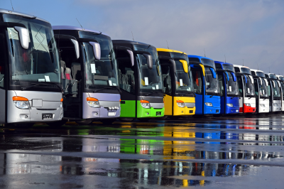
Bus transportation in Indonesia reveals the most about how ordinary people move around the country. Unlike airports that primarily serve middle and upper-income travelers, or trains that are limited to certain islands, buses serve everyone and go everywhere.
Terminal Kampung Rambutan in Jakarta exemplifies the organized chaos that characterizes Indonesian bus transportation. As one of Indonesia’s largest bus terminals, it handles hundreds of thousands of passengers daily traveling to destinations across Java and Sumatra. The terminal’s organization by destination zones helps passengers navigate what could otherwise be an overwhelming system.
Terminal Giwangan in Yogyakarta serves as Central Java’s main bus hub and demonstrates how bus terminals often become mini-cities themselves, with shops, restaurants, and services that support both travelers and the local economy. This illustrates an important principle in transportation planning – successful hubs become economic generators, not just transit points.
Leuwipanjang Terminal in Bandung shows how geography influences terminal design and operations. Located in the mountains of West Java, it demonstrates how bus transportation adapts to challenging terrain that might be difficult for other transport modes.
Terminal Bungurasih in Surabaya, known locally as Terminal Purabaya, serves East Java and illustrates how bus networks create regional connectivity that complements other transportation modes. From here, buses fan out to smaller cities and towns that airports and trains don’t serve.
Port Facilities

- Merak Port (Java) – Bakauheni Port (Sumatra) – Major ferry crossing
- Ketapang Port (Java) – Gilimanuk Port (Bali) – Java-Bali ferry
- Padang Bai Port, Bali – Connections to Lombok and eastern islands
- Tanjung Priok Port, Jakarta – Major cargo and passenger port
- Pelabuhan Benoa, Bali – International cruise terminal
Integrated Transportation Hubs
Jakarta’s Soekarno-Hatta Airport Railway Station demonstrates this integration principle by connecting air and rail transport directly. This allows passengers to travel from the airport to central Jakarta by train, reducing road congestion and providing more reliable transit times.
Gambir Station’s connections to Jakarta’s urban transport systems show how integration works at the city level. The station connects to TransJakarta bus rapid transit, providing seamless connections between long-distance rail and urban transport.

Major Airports
Ngurah Rai International Airport (DPS)
Bali’s main gateway is Ngurah Rai International Airport, also known as Denpasar International Airport. This modern facility serves as the primary entry point for international and domestic travelers. The airport is strategically located between Denpasar (the capital) and the popular tourist areas of Kuta, Seminyak, and Sanur.
Airport Transportation Options:
- Airport Taxi Service: Official blue taxis operate from designated counters inside the terminal
- Ride-hailing Apps: Grab and Gojek are available but pickup points are designated
- Hotel Transfers: Many accommodations offer pickup services
- Airport Bus: DAMRI buses connect to various destinations across Bali
Public Transportation in Bali
Trans Sarbagita Bus System
Trans Sarbagita represents Bali’s most organized public transportation network. This bus rapid transit system connects four major regions: Denpasar, Badung, Gianyar, and Tabanan (hence “Sarbagita”). The system operates on dedicated lanes in some areas, making it more reliable than regular traffic.
The buses are air-conditioned and relatively comfortable, operating from early morning until evening. This system works particularly well for traveling between major towns and avoiding the worst traffic congestion.
Traditional Bemo (Minivans)
Bemos are the traditional shared minivans that have served Bali for decades. These colorful vehicles follow fixed routes and represent the most authentic local transportation experience. However, they’re becoming less common as private transportation grows.
Understanding Bemo Operations:
- Routes are not always clearly marked for tourists
- Payment is made to the driver or conductor
- Vehicles depart when full rather than on fixed schedules
- Most useful for short distances between towns
Ojek (Motorcycle Taxis)
Traditional ojek involves riding as a passenger on a motorcycle, which remains popular for short distances and navigating narrow streets where cars cannot reach. This method is particularly useful in areas like Ubud’s rice terraces or remote temple locations.
Traditional Transportation Methods
Regular Taxis
Beyond Blue Bird, several taxi companies operate in Bali with varying levels of reliability. Always ensure the meter is used or negotiate fares beforehand. Airport taxis operate on fixed pricing to different zones across the island.
Tourist Shuttle Services
Many companies operate shared shuttle services connecting popular tourist destinations. These are particularly useful for longer distances like Kuta to Ubud or Sanur to Lovina. Companies like Perama Tour and Kura-Kura Bus provide scheduled services.
Rental Vehicles
Motorbike Rentals: Motorbikes offer the most flexibility for exploring Bali, allowing access to narrow roads and remote locations. International driving permits are technically required, though enforcement varies. Consider your riding experience carefully, as Bali’s traffic can be challenging.
Car Rentals: Self-drive car rentals are available, but many travelers prefer hiring a car with a driver due to traffic conditions and local driving customs. This option provides comfort while including local knowledge.
Specialized Transportation for Tourist Areas
Kura-Kura Bus
This hop-on, hop-off bus service specifically serves tourist areas, connecting beaches, shopping centers, and attractions in southern Bali. The service provides a convenient way to explore without worrying about parking or navigation.
Beach Area Transportation
Popular beach areas like Kuta, Seminyak, and Canggu have developed their own transportation ecosystems:
- Local shuttle services between beaches
- Bicycle rentals for short distances
- Walking paths connecting nearby areas
Regional Transportation Considerations
Northern Bali (Lovina, Singaraja)
Public transportation to northern Bali requires more planning, often involving connections through Denpasar. The journey takes significantly longer due to mountain roads and limited direct services.
Eastern Bali (Amed, Candidasa)
Eastern coastal areas have limited public transportation options. Tourist shuttles or private transportation work better for reaching these destinations.
Central Bali (Ubud Region)
Ubud has developed good connections to major areas through tourist shuttles and bemo services. Within Ubud, walking and cycling are popular for short distances.
Useful Websites and Resources
Grab Indonesia
Grab has become the dominant ride-hailing platform in Bali, offering several service categories that cater to different transportation needs.
Grab Services Available:
- GrabCar: Standard car rides with air conditioning
- GrabBike: Motorcycle taxi service for quick trips
- GrabCar Premium: Higher-end vehicles for comfort
- GrabShare: Shared rides to reduce costs
Gojek Indonesia
Gojek provides comprehensive services beyond transportation, making it a versatile app for travelers.
Gojek Transportation Options:
- GoRide: Motorcycle taxi service
- GoCar: Four-wheeled vehicle rides
- GoBluebird: Partnership with established taxi company
Additional Gojek Services:
- GoFood: Food delivery from restaurants
- GoMart: Grocery and convenience store delivery
- GoSend: Package and document delivery
Blue Bird Taxi App
Blue Bird represents Indonesia’s most established taxi company, known for reliability and metered fares. Their app provides an alternative to ride-hailing services.
Official Transportation Information
- Ngurah Rai Airport: Official site contains ground transportation information
- Bali Provincial Government Tourism: Provides updated transportation guidance
Booking Platforms
- 12Go Asia: Books various transportation options including ferries to neighboring islands
- Traveloka: Indonesian platform for booking flights, hotels, and local transportation
- Klook: Offers tourist transportation packages and airport transfers
Navigation and Maps
- Google Maps: Most reliable for navigation, includes public transport information
- Maps.me: Offline maps useful when internet connectivity is limited
- Waze: Popular for real-time traffic information among locals
Major Airports
Soekarno-Hatta International Airport (CGK)
Jakarta’s primary international gateway sits approximately 20 kilometers northwest of the city center. This massive airport complex serves as Indonesia’s busiest aviation hub and your most likely entry point into the capital. The airport itself functions almost like a small city, with two main terminals connected by an automated people mover system.
Airport Rail Link (Railink) The Airport Rail Link represents the fastest and most reliable connection between Soekarno-Hatta Airport and central Jakarta. This dedicated rail service operates on a schedule rather than depending on traffic conditions, making it particularly valuable during Jakarta’s notorious rush hours. The train connects to BNI City station in central Jakarta, where you can transfer to other transportation modes.
Airport Bus Services DAMRI operates comprehensive bus services connecting the airport to various destinations throughout Jakarta and surrounding areas. These air-conditioned buses follow fixed routes and schedules, providing an economical alternative to private transportation. The buses serve major hotels, shopping centers, and transportation hubs across the metropolitan area.
Ride-hailing and Taxi Services Both traditional taxis and ride-hailing applications serve the airport, though pickup procedures differ significantly. Traditional taxis operate from designated counters inside the terminal, while ride-hailing services like Grab and Gojek require meeting drivers at specific pickup zones outside the terminal buildings.
Halim Perdanakusuma Airport (HLP)
This smaller airport primarily serves domestic flights and some regional international routes. Located closer to the city center than Soekarno-Hatta, Halim offers more convenient access to central Jakarta areas. Transportation options include taxis, ride-hailing services, and some bus connections.
Understanding Jakarta’s Integrated Transportation System
Jakarta’s public transportation revolution centers around the concept of integration. Rather than operating as separate systems, the city has developed an approach where different modes connect seamlessly to create comprehensive coverage. This integration becomes evident through the JakLingko payment system, which works across multiple transportation modes, and through physical integration at major transit stations.
JakLinguistics Payment Integration
The JakLingko card system serves as the foundation for Jakarta’s integrated public transportation network, functioning as a universal payment method across buses, trains, and light rail systems. This card system represents more than just payment convenience; it enables seamless transfers between different transportation modes without requiring separate transactions for each service.
Understanding this integration helps you grasp why Jakarta’s transportation planning focuses on major interchange stations where multiple systems converge. These stations, like Dukuh Atas and Blok M, function as transportation hubs where you can transfer between different modes while maintaining fare integration.
The TransJakarta Bus Rapid Transit System
TransJakarta operates as the backbone of Jakarta’s public transportation network, moving millions of passengers daily through dedicated bus lanes that bypass regular traffic congestion. Think of this system as Jakarta’s subway network, but operating on dedicated roadways rather than underground tunnels.
Understanding the BRT Concept The Bus Rapid Transit concept means these buses operate more like trains than traditional city buses. They run on dedicated lanes separated from regular traffic, stop only at designated stations with platform boarding, and maintain frequent service throughout the day. This approach allows buses to maintain consistent schedules despite Jakarta’s traffic conditions.
Route Network Structure TransJakarta integrates with other transportation modes including MRT Jakarta, LRT Jakarta, and the Jabodetabek KRL commuter line to create an efficient and comprehensive public transportation system. The system operates through a hub-and-spoke model with major corridor routes connecting different areas of the city, supplemented by feeder routes that extend coverage into residential neighborhoods.
The corridor system uses numbering that reflects the chronological development of routes, with Corridor 1 being the original route from Blok M to Kota, and subsequent corridors expanding coverage throughout the metropolitan area. Understanding this numbering helps you navigate the system more effectively.
Jakarta Mass Rapid Transit (MRT)
The MRT represents Jakarta’s newest and most technologically advanced public transportation system. This fully automated subway system operates on Japanese technology and standards, providing air-conditioned comfort and precise scheduling that contrasts sharply with Jakarta’s traditionally chaotic transportation environment.
North-South Line Operations The currently operational MRT line connects Lebak Bulus in South Jakarta to the Bundaran HI area in Central Jakarta, passing through key districts including Senayan, Sudirman, and Thamrin. This route serves major business districts, shopping centers, and tourist attractions, making it particularly valuable for visitors.
The MRT operates with platform screen doors, automatic train control, and real-time passenger information systems that provide a level of predictability and comfort that attracts both local commuters and international visitors. Understanding how to use this system effectively provides access to Jakarta’s key business and commercial areas.
Light Rail Transit Systems
Jakarta operates multiple Light Rail Transit systems that serve different functions within the broader transportation network. These systems fill gaps between the high-capacity MRT and the extensive TransJakarta bus network.
LRT Jakarta LRT Jakarta aims to realize Jakarta without traffic jams through integrated rapid transit, serving as a comfortable and integrated public mobility solution. This system primarily serves the Kelapa Gading area in North Jakarta, connecting residential areas to commercial districts and providing access to the broader transportation network.
LRT Jabodebek The Jabodebek LRT extends beyond Jakarta proper to serve the greater metropolitan area, connecting Jakarta with neighboring cities in West Java. This system addresses the reality that Jakarta’s metropolitan area extends far beyond the city’s administrative boundaries, with millions of people commuting daily from surrounding areas.
Commuter Train Networks (KRL)
The KRL Commuter Line serves as Jakarta’s suburban rail network, connecting the city center with surrounding areas across multiple provinces. This electric train system carries enormous passenger volumes and represents the primary means of transportation for many residents living in Jakarta’s suburbs.
Understanding KRL Operations KRL trains operate on fixed schedules with high frequency during peak hours, using a zone-based system that covers Jakarta and surrounding areas. The system includes special cars designated for women during certain hours, reflecting cultural considerations in Indonesian public transportation.
Integration with Urban Systems KRL stations connect with urban transportation systems at key interchange points, allowing passengers to transfer between suburban and urban transportation modes. Major stations like Manggarai and Tanah Abang serve as crucial transfer points where suburban commuters can access MRT, TransJakarta, and other urban transportation options.
Traditional Transportation Methods
Despite the rapid modernization of Jakarta’s transportation system, traditional methods continue to serve important functions, particularly for short distances and areas not covered by formal public transportation.
Ojek (Motorcycle Taxis) Traditional ojek operates through informal networks of drivers who provide motorcycle taxi services, particularly useful for navigating narrow streets or reaching locations not accessible by larger vehicles. While ride-hailing applications have formalized much of this service, traditional ojek still operates in many neighborhoods.
Angkot (Shared Minivans) Angkot represents Jakarta’s traditional shared transportation system, operating fixed routes through neighborhoods and commercial areas. These colorful minivans follow established routes but lack the formal stations and schedules of modern BRT systems. Understanding angkot routes requires local knowledge, but they provide access to areas not served by formal public transportation.
Bajaj (Auto-rickshaws) Jakarta’s bajaj are three-wheeled vehicles that serve short to medium distances, particularly in areas with narrow streets or heavy traffic. These vehicles provide a cultural experience while serving practical transportation needs, though their numbers have decreased as modern transportation options have expanded.
Specialized Transportation Services
Jakarta offers various specialized transportation services that cater to specific needs or provide unique experiences within the city’s transportation ecosystem.
Airport Shuttle Services Multiple companies operate scheduled shuttle services connecting airports with various destinations throughout Jakarta and surrounding areas. These services provide a middle ground between private taxis and public buses, offering door-to-door service with shared vehicles.
Tourist Bus Services Jakarta offers tourist transport passes that provide unlimited rides on TransJakarta buses and MRT, making them excellent choices for sightseeing, along with specialized tour bus services for more relaxed experiences. These services cater specifically to visitors who want guided transportation experiences or hop-on-hop-off flexibility.
Hotel Shuttle Services Many hotels provide shuttle services to major shopping centers, business districts, or transportation hubs. These services often operate on fixed schedules and provide convenient connections between accommodations and key destinations.
Useful Websites and Digital Resources
Official Transportation Websites
- TransJakarta Official Website: Provides comprehensive route information, schedules, and service updates
- MRT Jakarta Official Website: Offers detailed system information, fare structures, and integration details
- LRT Jakarta Official Website: Contains route maps and operational information
- Jakarta Smart City Portal: Provides comprehensive information including the Jakarta Sustainable Transportation Map and Guide that covers routes, fares, and operating hours for the entire public transportation network
Third-Party Planning Resources
- Moovit: Comprehensive public transportation planning application with real-time information
- Google Maps: Provides integrated route planning across multiple transportation modes
- Traveloka: Indonesian platform offering transportation booking and information services
Government Resources
- Jakarta Provincial Government Transportation Information: Official updates on transportation policies and developments
- Ministry of Transportation Indonesia: National transportation policies and interstate connections
Practical Integration Strategies
Successfully navigating Jakarta requires understanding how to combine different transportation modes for optimal efficiency. This integration thinking helps you move efficiently through a city where single-mode transportation rarely provides the best solution.
Hub-Based Navigation Major transportation hubs like Dukuh Atas, Blok M, and Manggarai serve as strategic transfer points where multiple systems converge. Planning journeys that utilize these hubs allows for efficient transfers and often provides multiple routing options if one system experiences delays.
Time-Based Mode Selection Different transportation modes perform better at different times. During peak traffic hours, rail-based systems (MRT, KRL, LRT) typically provide more reliable service than road-based systems. During off-peak hours, the full range of options becomes more viable, allowing for mode selection based on convenience and destination accessibility.
Payment Integration Strategy Understanding the JakLingko payment system enables seamless movement across different transportation modes without the friction of separate payment processes. This integration extends beyond convenience to provide fare benefits for multi-modal journeys.
Reaching Yogyakarta
By Air:
Yogyakarta International Airport (YIA) This newer airport represents Indonesia’s investment in modern infrastructure. Located about 50 kilometers southeast, it’s designed to handle larger aircraft and international traffic. The distance might seem daunting, but consider this: the airport was deliberately placed away from the dense urban core to allow for expansion and reduce noise pollution. This placement means your journey into the city becomes part of the experience, taking you through rural landscapes before entering the urban environment.
By Rail:
Tugu Railway Station Railway travel in Indonesia has been undergoing modernization, and Yogyakarta benefits significantly from this. The station connects you to Java’s extensive rail network, which operates on predictable schedules unlike road transport that can be affected by traffic. When you arrive by train, you’re deposited directly into the city’s transportation hub, making onward connections seamless.
By Road:
Giwangan Bus Terminal Bus travel remains the most economical way to reach Yogyakarta from distant locations. The terminal system in Indonesia follows a hub-and-spoke model, where major terminals like Giwangan serve as distribution points for smaller local routes. This means you might need to understand the connection system to reach your final destination efficiently.
Public Transportation
Yogyakarta’s transportation system represents a fascinating blend of preservation and progress. Let me help you understand how these different layers work together.
Becak and Andong
These aren’t just tourist attractions but functional parts of the transportation network. Becak (pedicabs) excel in areas where motor vehicles struggle, particularly the narrow lanes around the Kraton and traditional markets. Think of them as the capillary system of urban transport, reaching areas where larger vehicles cannot go.
Andong (horse carts) serve a similar function while preserving cultural heritage. Understanding when to use these traditional options versus modern alternatives comes down to recognizing the urban fabric you’re navigating.
Trans Jogja System
The Trans Jogja bus rapid transit system represents Indonesia’s approach to solving urban mobility challenges. Built on dedicated lanes, it operates similarly to subway systems in other cities but adapted to Yogyakarta’s geography and budget constraints. The system uses a hub-and-spoke model with major terminals at key locations like Malioboro, connecting to smaller feeder routes. Learning to read the Trans Jogja map is like understanding the city’s circulatory system, each route serving different functions in moving people efficiently.
Ride-Hailing Revolution
The emergence of Gojek and Grab has fundamentally changed urban mobility in Indonesia. These platforms solve several traditional problems: language barriers (apps in multiple languages), price transparency (no negotiation needed), safety (tracked rides), and service reliability. Understanding how to leverage these apps effectively means recognizing that they offer much more than just transportation.
Useful Digital Resources
Gojek: The Super App Concept Gojek represents Indonesia’s approach to the “super app” model, where one platform provides multiple services. For transportation, this means you can seamlessly combine different services within one ecosystem. GoRide motorcycle taxis excel in heavy traffic and narrow streets, while GoCar provides comfort for longer distances or when carrying luggage. The genius of this system is that you can plan multimodal journeys within one app, something traditional transportation couldn’t offer.
Grab: The Regional Alternative Grab operates across Southeast Asia, which means if you’re traveling regionally, your familiarity with the app transfers between countries. In Yogyakarta, Grab often provides competitive alternatives to Gojek, and having both apps installed gives you options when one has longer wait times or higher demand pricing.
Navigation: Beyond Basic Directions Google Maps in Indonesian cities provides more than directions; it shows real-time public transport information, walking routes that account for pedestrian infrastructure, and business hours that help you plan trips. Waze becomes particularly valuable during peak hours, as local users contribute real-time traffic and road condition information. Maps.me serves as your backup when internet connectivity becomes unreliable, something that can happen in certain parts of the city.
Booking Platforms: Traveloka and Tiket.com These platforms integrate with Indonesia’s transportation infrastructure in ways that international booking sites might not. They often have partnerships with local operators, providing options and schedules that you won’t find elsewhere. Understanding how to use these platforms means accessing the full range of transportation options available to local residents.

Entry Points:
Medan:
Kualanamu International Airport near Medan serves as Sumatra’s primary international gateway, handling flights from Malaysia, Singapore, Thailand, and major Indonesian cities. When you arrive here, you’re entering Sumatra’s most developed transportation hub. The airport connects to Medan city through dedicated rail links, buses, and ride-hailing services, but more importantly, it positions you at the northern end of the Trans-Sumatran Highway, the island’s primary north-south artery.
Understanding Medan’s role helps you grasp why many travelers use it as a base for exploring northern and central Sumatra. The city’s transportation infrastructure radiates outward like a wheel, with connections to destinations like Lake Toba, Berastagi, and the Leuser National Park. This hub-and-spoke pattern repeats throughout Sumatra but is most developed in the Medan region.
Padang:
Minangkabau International Airport in Padang provides access to western Sumatra’s cultural heartland. This entry point offers a different perspective on Sumatran transportation because it connects you to the highland regions and the traditional Minangkabau territories. The transportation patterns here reflect the mountainous geography, with routes following river valleys and highland plateaus rather than the coastal plains that dominate eastern Sumatra.
Lampung:
Radin Intan II Airport in Lampung serves as the connection point between Sumatra and Java. This region’s transportation significance comes from its role as a transit zone, where ferry connections to Java create a land-sea transportation continuum. Understanding Lampung helps you see how Sumatra fits into Indonesia’s broader inter-island transportation network.
Sea Connections:
Ferry services from Malaysia and various Indonesian islands add another layer to Sumatra’s transportation complexity. Ports like Dumai, Batam connections, and Medan’s Belawan port create international and domestic sea routes that complement air connections. These maritime gateways often serve different purposes than airports, typically handling cargo and budget-conscious travelers who combine sea and land transport.
Understanding Sumatra’s Primary Transportation Corridors
The Trans-Sumatran Highway:
This highway system represents Indonesia’s ambitious attempt to create a unified transportation corridor running the length of Sumatra, connecting major cities like Medan, Pekanbaru, Padang, Palembang, and Bandar Lampung. However, understanding this highway requires recognizing that it’s not a single continuous road but rather a network of interconnected segments with varying quality and capacity.
The highway’s construction reflects Sumatra’s challenging geography. Some sections run along flat coastal plains with excellent road conditions, while others traverse mountainous regions with steep grades, sharp curves, and occasional weather-related closures. This variation means your travel time and comfort can change dramatically as you move between different segments.
Coastal Routes: The Eastern Corridor
The eastern coastal region, being flatter and more densely populated, supports better road infrastructure and more frequent public transport services. This corridor connects major economic centers and ports, creating a natural pathway for both passenger and freight transport. Understanding this eastern emphasis helps explain why certain destinations are more easily accessible than others.
Highland Connections: The Challenging Crossroads
East-west connections across Sumatra’s mountainous spine present unique transportation challenges. These routes, while often spectacularly scenic, require different planning approaches due to longer travel times, weather considerations, and limited service frequencies. The highland routes serve smaller communities and tourist destinations like Lake Toba, Bukittinggi, and various national parks.
Public Transportation:
Sumatra’s public transportation system operates on multiple levels, each serving different functions within the broader network. Let me help you understand how these systems interconnect and when to use each option.
Inter-City Bus Networks:
Long-distance buses form the backbone of public transportation across Sumatra. These services operate from major terminals in each city, creating a hub-and-spoke pattern that mirrors the island’s urban hierarchy. Understanding the bus system requires recognizing that different companies specialize in different routes and service levels.
The bus network operates on a hierarchy of services. Express buses connect major cities with minimal stops, while local buses serve smaller towns and villages along the routes. Night buses maximize travel time efficiency by moving passengers while they sleep, though this requires understanding comfort levels and safety considerations for overnight travel.
Urban Transportation: City-Specific Solutions
Each major Sumatran city has developed its own urban transportation character. Medan operates angkot (shared minibuses) alongside modern ride-hailing services, creating a layered system where traditional and modern transport coexist. Padang’s hilly terrain influences its local transport patterns, while Palembang’s river geography adds waterborne transport options.
Rail Connections:
Sumatra’s railway system, while limited compared to Java’s extensive network, serves strategic functions in certain regions. The lines that do exist typically connect major economic centers with ports or industrial areas. Understanding where rail service is available helps you identify opportunities for comfortable, weather-independent travel.
Apps and Technology Integration
The emergence of smartphone-based transportation apps has transformed mobility across Sumatra, but understanding how to use these tools effectively requires recognizing their limitations and strengths in different contexts.
Gojek and Grab: The Urban Enablers These ride-hailing platforms have revolutionized urban transportation in Sumatra’s major cities, providing solutions to traditional problems like language barriers, price negotiations, and service reliability. However, their effectiveness varies significantly between cities and regions. In Medan, you’ll find comprehensive coverage and multiple service options, while smaller cities might have limited driver availability or service types.
Navigation and Planning Tools Google Maps provides valuable route planning across Sumatra, but its effectiveness varies by region and transport mode. In urban areas and along major highways, the app provides reliable real-time information. However, in remote areas or for traditional transport options, local knowledge often proves more valuable than digital tools.
Maps.me becomes particularly important for offline navigation during long overland journeys where internet connectivity might be intermittent. Understanding how to download offline maps for your intended routes provides security against connectivity issues.
Booking Platforms: Traveloka and Local Alternatives Online booking platforms have made it easier to reserve seats on buses and flights, but understanding their coverage limitations helps you plan effectively. Some transportation providers, particularly smaller local operators, might not participate in online booking systems, requiring direct contact or in-person booking.

The primary gateway is Lombok International Airport (Bandara Internasional Lombok) in the southern part of the island. This modern airport, which opened in 2011, serves as your most convenient entry point from major Indonesian cities like Jakarta, Surabaya, and Bali, as well as some international destinations.
Your second option involves a more scenic but longer journey through Bali. You would fly into Ngurah Rai International Airport in Bali, then take either a fast boat or ferry across the Lombok Strait. This route appeals to travelers who want to experience the journey as part of their adventure, though it requires more time and planning.
Understanding Lombok’s Transportation Landscape
Before diving into specific options, it’s helpful to understand that Lombok’s transportation system operates quite differently from what you might expect in more developed tourist destinations. The island lacks comprehensive public bus networks or rail systems that you’d find in places like Java or Bali. Instead, transportation revolves around a mix of traditional and modern options that reflect the island’s developing infrastructure.
Public Transportation Options
Bemo and Cidomo: Traditional Local Transport
Bemo represents Lombok’s primary form of traditional public transport. These are small minivans or pickup trucks with benches in the back, operating on loosely defined routes between towns and villages. Think of them as shared taxis that follow general paths rather than fixed schedules. You’ll find them most useful for traveling between major towns like Mataram, Cakranegara, and Senggigi.
Cidomo offers a unique cultural experience, particularly in areas like the Gili Islands and some parts of mainland Lombok. These are horse-drawn carts that serve both transportation and tourism purposes. While not practical for long distances, they provide an authentic glimpse into traditional Indonesian transport methods.
Ojek: Motorcycle Taxis
Ojek represents one of the most flexible transportation options available. These motorcycle taxis can navigate narrow roads and traffic that larger vehicles cannot manage. Traditional ojek drivers typically wait at strategic locations like markets, ferry terminals, and popular tourist spots. You negotiate the fare directly with the driver before starting your journey.
Useful Websites and Planning Resources
Gojek: The Comprehensive Solution
Gojek functions as Indonesia’s leading ride-hailing platform, offering much more than simple transportation. The app provides motorcycle rides (GoRide), car rides (GoCar), food delivery (GoFood), and various other services. In Lombok, Gojek’s motorcycle service proves particularly valuable because motorcycles can access areas where cars struggle with narrow roads or traffic congestion.
Grab: Alternative Ride-Hailing
Grab serves as Gojek’s main competitor and offers similar services, though with somewhat different coverage areas in Lombok. Some travelers find Grab’s interface more user-friendly, particularly if you’re not familiar with Indonesian apps. Like Gojek, Grab offers both motorcycle and car options, though motorcycle services tend to be more readily available.
Official Tourism Websites
The West Nusa Tenggara Tourism Office website provides official information about transportation infrastructure and current conditions. While not always updated frequently, it offers reliable baseline information about ferry schedules and airport connections.
Ferry and Boat Booking Platforms
Several online platforms help you book fast boat tickets between Bali and Lombok, as well as services to the Gili Islands. Websites like 12Go Asia aggregate different boat operators and allow you to compare schedules and book tickets in advance. This proves particularly valuable during peak tourist seasons when boats fill up quickly.
Google Maps:
Google Maps works remarkably well in Lombok, providing accurate directions for both driving and walking. The app includes many local businesses and can help you locate ojek stations, bemo stops, and other transportation hubs. Download offline maps before traveling to areas with poor internet connectivity.
Getting Around Different Areas of Lombok
Mataram and Cakranegara: Urban Transportation
These connected cities form Lombok’s administrative and commercial center. Here you’ll find the most developed transportation options, including regular bemo services, abundant ojek drivers, and good coverage from ride-hailing apps. The cities are compact enough that walking between nearby destinations remains feasible, though the tropical heat makes motorcycle rides more comfortable for longer distances.
Senggigi: Tourist-Focused Transport
Senggigi, being Lombok’s primary beach resort area, offers more tourist-oriented transportation services. Many hotels provide shuttle services to the airport or popular attractions. You’ll find plenty of ojek drivers familiar with tourist destinations, and ride-hailing apps work well in this area due to the concentration of smartphone users.
Rural and Mountain Areas
Transportation becomes more challenging as you venture into Lombok’s rural areas or attempt to reach destinations like Mount Rinjani’s trailheads. Public bemo services become less frequent and may not reach remote locations. For these areas, consider arranging private transport through your accommodation or hiring a driver for the day.
Specialized Transportation for Popular Activities
Reaching the Gili Islands
Fast boats operate regularly between Lombok’s Bangsal Harbor and the three Gili Islands. These boats typically run every hour during daylight hours, though schedules can vary based on weather conditions and passenger demand. Some operators allow online booking, while others require you to purchase tickets at the harbor.
Public boats also connect Lombok to the Gilis, offering a more economical but slower option. These larger vessels operate on less frequent schedules but provide a more authentic local experience.
Mount Rinjani Trekking Access
Reaching Mount Rinjani’s trailheads requires careful planning since public transportation doesn’t extend to these remote areas. Most trekkers arrange transportation through their trekking company or hire private drivers. The journey from Senggigi or Mataram to trailheads like Sembalun or Senaru typically takes two to three hours depending on road conditions.

Before we dive into transportation specifics, it’s crucial to understand that Indonesian Borneo, known as Kalimantan, covers roughly 73% of the world’s third-largest island. This vast territory is divided into five provinces: West Kalimantan (Kalimantan Barat), Central Kalimantan (Kalimantan Tengah), South Kalimantan (Kalimantan Selatan), East Kalimantan (Kalimantan Timur), and North Kalimantan (Kalimantan Utara). Each province operates somewhat independently in terms of transportation infrastructure, making your journey planning more complex than in more centralized regions.
The massive river systems, particularly the Kapuas, Barito, and Mahakam rivers, historically served as the primary highways for this region. This river-centric development means that many communities remain more accessible by water than by road, even today.
Entry Points and Initial Access
Your journey to Indonesian Borneo typically begins through one of several major airports that serve as gateways to different regions.
Balikpapan’s Sultan Aji Muhammad Sulaiman Airport in East Kalimantan functions as the primary international gateway, handling flights from major Indonesian cities and some international destinations. This airport serves as your best entry point if you’re planning to explore East Kalimantan’s oil-rich regions, coastal areas, or access points to inland adventures.
Banjarmasin’s Syamsudin Noor Airport in South Kalimantan provides another significant entry point, particularly valuable if your interests lie in the southern regions or if you want to explore the famous floating markets and wetland ecosystems. Meanwhile, Pontianak’s Supadio Airport in West Kalimantan serves those heading toward the Malaysian border regions or planning to explore the Kapuas River system.
Each of these airports connects you to Indonesia’s major cities through regular domestic flights, but understanding which airport best serves your intended destinations requires careful consideration of your planned itinerary. The distances between provinces in Kalimantan are substantial, and overland travel between them can be time-consuming and challenging.
River Transportation:
To truly understand transportation in Kalimantan, you must appreciate the central role that rivers play in regional mobility. The river systems don’t just provide transportation; they form the backbone of community life, commerce, and cultural exchange. These waterways offer access to remote communities that remain unreachable by road, making river travel essential for comprehensive exploration of the region.
Regular passenger boats operate along major rivers, providing scheduled services between significant towns and cities. These boats vary greatly in size and comfort level, from small speedboats that navigate shallow tributaries to larger vessels that can accommodate dozens of passengers for multi-day journeys. The Kapuas River system in West Kalimantan, for example, supports regular boat services from Pontianak deep into the interior, reaching communities that exist primarily along the riverbanks.
Schedules depend heavily on water levels, weather conditions, and passenger demand. During dry seasons, some routes become impassable, while rainy seasons can create dangerous conditions that halt services. This variability means you must build flexibility into your travel plans and consider river conditions as a fundamental factor in your itinerary planning.
Overland Transportation Networks
Kalimantan’s road network reflects the region’s challenging geography and relatively recent development. Major highways connect provincial capitals and significant towns, but road quality varies dramatically. The Trans-Kalimantan Highway represents an ambitious project to connect the island’s major cities, though completion remains ongoing, and some sections experience seasonal accessibility issues.
Bus services operate between major cities, providing the most economical option for long-distance overland travel. These buses range from basic local services to more comfortable air-conditioned coaches that serve longer routes. Understanding that journey times can extend significantly beyond what maps might suggest is essential, as road conditions, weather, and frequent stops affect travel duration.
Rental cars and motorcycles provide independence for exploring Kalimantan, though this option requires careful consideration of your driving experience and comfort with challenging road conditions. Many rental agencies operate in major cities, and having your own vehicle allows access to remote destinations that public transportation cannot reach.
Specialized Transportation for Eco-Tourism and Adventure Travel
Kalimantan’s appeal often centers on its pristine rainforests, wildlife viewing opportunities, and remote indigenous communities. Reaching these destinations frequently requires specialized transportation arrangements that go beyond conventional public transport options.
Organized tours often provide the most practical solution for accessing remote natural areas. These tours typically include specialized transportation such as 4WD vehicles for rough terrain, boats for river navigation, and sometimes even chartered flights to extremely remote locations. Tour operators possess essential local knowledge about current conditions, seasonal accessibility, and safety requirements.
For independent travelers seeking to reach remote destinations, establishing connections with local guides and transportation providers becomes crucial. Many remote communities rely on informal transportation networks that operate through personal relationships and local knowledge rather than published schedules or online booking systems.
Digital Resources and Planning Tools
Google Maps provides reasonable coverage for major routes in Kalimantan, though accuracy decreases significantly in remote areas. The platform proves valuable for planning routes between major cities and understanding general distances, but always verify current road conditions locally before embarking on long journeys.
Indonesian government tourism websites offer official information about transportation infrastructure, though updates may be infrequent, and information quality varies between provinces. Provincial tourism offices sometimes maintain websites with current information about local transportation options and seasonal considerations.
Gojek operates in Kalimantan’s major cities, though coverage varies significantly between urban centers and rural areas. In cities like Balikpapan, Banjarmasin, and Pontianak, you can reliably use Gojek for motorcycle rides (GoRide) and car services (GoCar). The app proves particularly valuable in these urban environments where traffic congestion and limited parking make motorcycle transport more efficient than cars.
However, understanding Gojek’s limitations in Kalimantan is crucial for realistic planning. The service concentrates in developed urban areas and may not extend to smaller towns or rural destinations. As you venture beyond major cities, traditional transportation methods become increasingly important.
Grab provides similar services in select urban areas, though with more limited coverage than Gojek. Some travelers find Grab’s interface more intuitive, particularly for international visitors who may struggle with Indonesian-language apps. Both platforms require active internet connections, which can be spotty in remote areas of Kalimantan.
Your journey to Sulawesi typically begins through one of several major airports that serve as gateways to different regions. Sultan Hasanuddin Airport in Makassar serves as the primary entry point for South Sulawesi and connects internationally to cities like Kuala Lumpur and Singapore, while domestically linking to Jakarta, Surabaya, Denpasar, and other Indonesian cities.
For Central Sulawesi, Mutiara SIS Al-Jufrie Airport in Palu provides access, though with more limited connections.
North Sulawesi travelers usually arrive at Sam Ratulangi Airport in Manado, which offers both domestic routes and some international connections to the Philippines and Singapore.
Ferry connections provide an alternative approach, particularly if you’re island-hopping through Indonesia. Regular ferry services connect Sulawesi to Java, Kalimantan, and the Maluku Islands, with major ports in Makassar, Bitung, and Kendari serving as important maritime gateways.
Understanding Sulawesi’s Transportation Landscape
To truly grasp how to navigate Sulawesi, you need to understand that this island presents unique challenges compared to Java or Bali. The mountainous terrain and sprawling peninsulas mean that what looks like a short distance on a map often translates to lengthy, winding journeys by road. The infrastructure varies dramatically between regions, with South Sulawesi generally offering the most developed transportation networks.
Inter-City and Long-Distance Transportation
Bus travel forms the backbone of long-distance public transportation across Sulawesi. The bus network is most comprehensive in South Sulawesi, where you’ll find regular services connecting Makassar to major cities like Pare-Pare, Bone, Palopo, and Watampone. These buses range from basic economy services to more comfortable air-conditioned coaches with reclining seats.
For longer journeys, such as traveling between different peninsulas, overnight buses become essential. The journey from Makassar to Palu in Central Sulawesi, for example, typically takes 12-15 hours and involves traversing challenging mountain roads. Similarly, reaching Manado in North Sulawesi from southern cities requires extensive overland travel, often taking 18-20 hours or more.
Shared taxis and minivans, offer a faster but more expensive alternative to buses for intercity routes. These typically seat 6-8 passengers and depart when full, providing door-to-door service between major cities.
Regional and Local Transportation
Within each region of Sulawesi, you’ll encounter different transportation systems adapted to local geography and population density. In urban areas like Makassar, Manado, and Palu, you’ll find established public transportation networks, while rural areas rely more heavily on informal transportation systems.
Angkot (short for angkutan kota) represent the most common form of urban public transport. These colorful minivans follow fixed routes through cities and towns, picking up and dropping off passengers along the way. Each route typically has a specific color scheme or number, and while there aren’t always official route maps, locals can easily direct you to the right angkot for your destination.
Ojek, or motorcycle taxis, provide essential last-mile connectivity throughout Sulawesi. Traditional ojek operate from fixed points or can be hailed on the street, while app-based services have gained popularity in larger cities. The motorcycle’s ability to navigate narrow streets and traffic makes it particularly valuable in Sulawesi’s varied terrain.
Becak (bicycle rickshaws) still operate in some traditional areas, particularly in smaller towns and historic districts, though they’re becoming less common as motorized transport dominates.
Digital Transportation Platforms
- Gojek stands as the most widely available ride-hailing platform, offering motorcycle taxi services (GoRide) and car services (GoCar) in major cities like Makassar and Manado. The app also provides food delivery and other services that can be helpful for travelers.
- Grab operates in select cities on Sulawesi, primarily focusing on major urban centers. Their motorcycle taxi service proves particularly useful for short-distance travel and navigating congested areas.
- Traveloka serves as a comprehensive platform for booking buses, flights, and hotels throughout Indonesia, including routes within Sulawesi.
- RedBus specializes in bus bookings and covers many routes across the island, allowing you to compare different operators and departure times.
Maritime Transportation Within Sulawesi
Given Sulawesi’s extensive coastline and numerous offshore islands, boats and ferries play crucial roles in the transportation network. Regular ferry services connect the mainland to islands like the Togean Islands in Central Sulawesi and the Wakatobi archipelago in Southeast Sulawesi. These maritime routes often provide the only practical access to remote coastal communities and diving destinations.
Traditional wooden boats called “kapal motor” provide transportation along coastlines and between islands, operating on flexible schedules that depend on weather conditions and passenger demand. While less predictable than scheduled ferries, these boats offer authentic local transportation experiences and access to remote areas.
Specialized Transportation for Tourism
Sulawesi’s diverse attractions require specialized transportation considerations. For visiting national parks like Lore Lindu or Bogani Nani Wartabone, you’ll typically need to arrange private transportation or join organized tours, as public transport rarely extends into these protected areas.
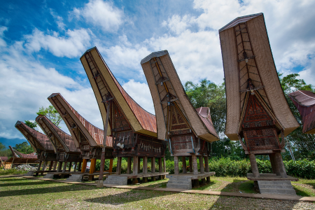
Cave systems like those in Maros-Pangkep require local guides and specialized transport arrangements. Similarly, reaching traditional Toraja villages in the highlands often involves hiring local drivers familiar with mountain roads and cultural protocols.
For diving destinations like Bunaken or the Togean Islands, transportation arrangements usually involve coordination between land transport to coastal departure points and boat transfers to dive sites.